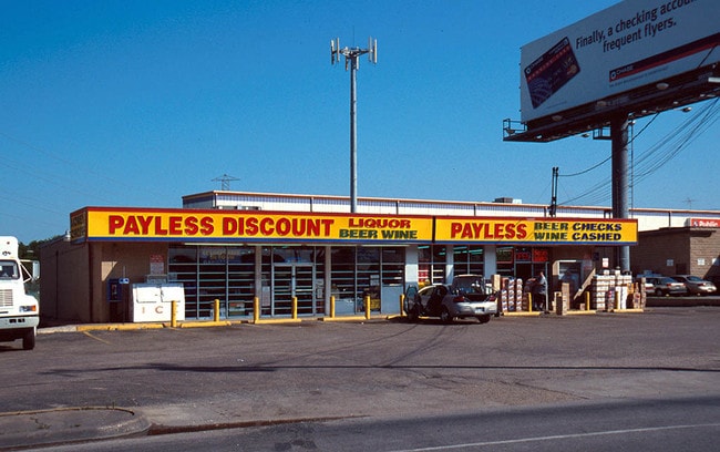
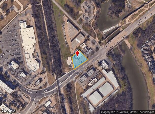
Property Record
7729 Garland Rd, Dallas, TX 75218
NEARBY LISTINGS FOR SALE OR LEASE
-
-
-
-
-
-
No Photo
-
-
View all Dallas listings for sale on LoopNet.com
Property Detail
7729 Garland Rd
Dallas-Fort Worth-Arlington, TX
Goody
002744000A0030000
GOODY BLK A/2744 LT 3 ACS 0.613 VOL93006/1863 EX010893 CO-DC 2744 00A 00300 1DA2744 00A
Storebuilding
Dallas
AE
Texas
48113C0355K
3
2024
0.61 AC
2025
Lakewood
000100
Dallas/Ft Worth
7,357 SF
DEMOGRAPHICS near 7729 Garland Rd
1 Mile
3 Mile
5 Mile
2024 Total Population
10,365
129,456
436,475
2029 Population
10,329
129,395
437,338
Pop Growth 2024-2029
(0.35%)
(0.05%)
+ 0.20%
Average Age
37
37
36
2024 Total Households
4,823
54,908
193,628
HH Growth 2024-2029
(0.41%)
(0.04%)
+ 0.40%
Median Household Inc
$95,315
$70,810
$68,688
Avg Household Size
2.10
2.30
2.20
2024 Avg HH Vehicles
2.00
2.00
2.00
Median Home Value
$686,151
$423,443
$374,015
Median Year Built
1984
1968
1980
Nearby Places
Map Layers
Map Styles
 Street
 Aerial
- Restaurants
- Banks
- Shops
- Fitness
- Groceries
PUBLIC TRANSPORTATION
COMMUTER RAIL
DRIVE
WALK
Distance
12 min
6.5 mi
DRIVE
WALK
Distance
16 min
8.4 mi
AIRPORT
Dallas Love Field
DRIVE
WALK
Distance
Dallas Love Field
20 min
9.8 mi
Dallas-Fort Worth International
DRIVE
WALK
Distance
Dallas-Fort Worth International
36 min
25.9 mi
Nearby Properties
Address
Land Use
TOTAL SIZE
Lot Size
Zoning
Address
Land Use
TOTAL SIZE
Lot Size
Zoning
763,340 SF
8.31 AC
Z165
Address
Land Use
TOTAL SIZE
Lot Size
Zoning
717,809 SF
4.88 AC
Z239
Address
Land Use
TOTAL SIZE
Lot Size
Zoning
583,186 SF
4.54 AC
Z239
Address
Land Use
TOTAL SIZE
Lot Size
Zoning
372,564 SF
13.34 AC
Z164
Address
Land Use
TOTAL SIZE
Lot Size
Zoning
336,786 SF
4.30 AC
Z239
Address
Land Use
TOTAL SIZE
Lot Size
Zoning
32,530 SF
0.02 AC
Z239
Address
Land Use
TOTAL SIZE
Lot Size
Zoning
392,842 SF
16.79 AC
Z164
Address
Land Use
TOTAL SIZE
Lot Size
Zoning
432,104 SF
3.75 AC
Z239
Address
Land Use
TOTAL SIZE
Lot Size
Zoning
691,816 SF
19.50 AC
Z239
Address
Land Use
TOTAL SIZE
Lot Size
Zoning
397,809 SF
18.04 AC
Z298
Address
Land Use
TOTAL SIZE
Lot Size
Zoning
367,979 SF
1.27 AC
Z239
Address
Land Use
TOTAL SIZE
Lot Size
Zoning
239,221 SF
11.01 AC
Z164
Address
Land Use
TOTAL SIZE
Lot Size
Zoning
368,350 SF
1.21 AC
Z59
Address
Land Use
TOTAL SIZE
Lot Size
Zoning
252,473 SF
7.28 AC
Z165
Address
Land Use
TOTAL SIZE
Lot Size
Zoning
190,287 SF
5.80 AC
Z163
Address
Land Use
TOTAL SIZE
Lot Size
Zoning
445,781 SF
4.57 AC
Z239
Address
Land Use
TOTAL SIZE
Lot Size
Zoning
245,023 SF
6.84 AC
Z164
Address
Land Use
TOTAL SIZE
Lot Size
Zoning
247,421 SF
3.96 AC
Z133
Address
Land Use
TOTAL SIZE
Lot Size
Zoning
284,990 SF
24.80 AC
Z298
Address
Land Use
TOTAL SIZE
Lot Size
Zoning
509,014 SF
30.82 AC
Z31
Address
Land Use
TOTAL SIZE
Lot Size
Zoning
349,156 SF
10.86 AC
Z59
Address
Land Use
TOTAL SIZE
Lot Size
Zoning
196,386 SF
7.24 AC
Z164
Address
Land Use
TOTAL SIZE
Lot Size
Zoning
167,340 SF
11.24 AC
Z59
Address
Land Use
TOTAL SIZE
Lot Size
Zoning
244,575 SF
9.91 AC
Z164
Address
Land Use
TOTAL SIZE
Lot Size
Zoning
174,353 SF
12.64 AC
Z248
Address
Land Use
TOTAL SIZE
Lot Size
Zoning
171,348 SF
5.70 AC
Z164
Address
Land Use
TOTAL SIZE
Lot Size
Zoning
289,172 SF
12.56 AC
Z164
Address
Land Use
TOTAL SIZE
Lot Size
Zoning
63,923 SF
5.22 AC
Z200
Address
Land Use
TOTAL SIZE
Lot Size
Zoning
110,327 SF
4.12 AC
Z239
Address
Land Use
TOTAL SIZE
Lot Size
Zoning
294,140 SF
2.45 AC
Z239
The World's #1 Commercial Real Estate Marketplace
Connect with us
© 2025 CoStar Group
The information above has been obtained from sources believed reliable. While we do not doubt its accuracy we have not verified it and make no guarantee, warranty or representation about it. It is your responsibility to independently confirm its accuracy and completeness. Any projections, opinions, assumptions, or estimates used are for example only and do not represent the current or future performance of the property. The value of this transaction to you depends on tax and other factors which should be evaluated by your tax, financial, and legal advisors. You and your advisors should conduct a careful, independent investigation of the property to determine to your satisfaction the suitability of the property for your needs.