Property Record
7734 Airways Blvd, Southaven, MS 38671
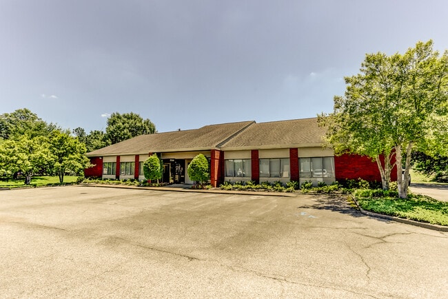
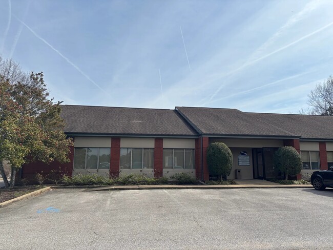
This Property Is For Sale
Current Lease Availabilities
NEARBY LISTINGS FOR SALE OR LEASE
Property Detail
7734 Airways Blvd
Memphis, TN-MS-AR
Lebonheur Ambulatory 4Th Rev
1079300000000301
UNIT A LEBONHEUR AMBULATORY BIRCHBEND OFFICE CONDO IMPROVEMENTS ONLY PT LOT 1
Realpropertynec
DeSoto
AE
Mississippi
47157C0580F
1
2024
0.30 AC
2024
DeSoto County
070522
Memphis
3,219 SF
DEMOGRAPHICS near 7734 Airways Blvd
1 Mile
3 Mile
5 Mile
2024 Total Population
7,071
49,645
125,246
2029 Population
7,655
53,150
132,544
Pop Growth 2024-2029
+ 8.26%
+ 7.06%
+ 5.83%
Average Age
39
38
38
2024 Total Households
2,749
19,231
47,204
HH Growth 2024-2029
+ 8.29%
+ 7.13%
+ 5.84%
Median Household Inc
$50,502
$51,507
$52,569
Avg Household Size
2.50
2.50
2.60
2024 Avg HH Vehicles
2.00
2.00
2.00
Median Home Value
$142,744
$156,094
$167,617
Median Year Built
1983
1985
1984
Nearby Places
- Restaurants
- Banks
- Shops
- Fitness
- Groceries
PUBLIC TRANSPORTATION
AIRPORT
Memphis International
DRIVE
WALK
Distance
Memphis International
11 min
6.5 mi
Freight Ports
Port of Shreveport
DRIVE
WALK
Distance
Port of Shreveport
415 min
381.5 mi
Nearby Properties
Address
Land Use
TOTAL SIZE
Lot Size
Zoning
Address
Land Use
TOTAL SIZE
Lot Size
Zoning
1,013,319 SF
38.86 AC
EMP
Address
Land Use
TOTAL SIZE
Lot Size
Zoning
986,374 SF
68.79 AC
CA
Address
Land Use
TOTAL SIZE
Lot Size
Zoning
732,894 SF
79.73 AC
WD
Address
Land Use
TOTAL SIZE
Lot Size
Zoning
586,847 SF
37 AC
CA
Address
Land Use
TOTAL SIZE
Lot Size
Zoning
328,300 SF
33.78 AC
CA
Address
Land Use
TOTAL SIZE
Lot Size
Zoning
853,440 SF
39.22 AC
EMP
Address
Land Use
TOTAL SIZE
Lot Size
Zoning
321.59 AC
R-8
Address
Land Use
TOTAL SIZE
Lot Size
Zoning
265,600 SF
22.03 AC
CA
Address
Land Use
TOTAL SIZE
Lot Size
Zoning
63,842 SF
11 AC
R-6
Address
Land Use
TOTAL SIZE
Lot Size
Zoning
432,700 SF
28.16 AC
EMP
Address
Land Use
TOTAL SIZE
Lot Size
Zoning
1,040,736 SF
57.67 AC
M-1
Address
Land Use
TOTAL SIZE
Lot Size
Zoning
188,404 SF
59.17 AC
R-8
Address
Land Use
TOTAL SIZE
Lot Size
Zoning
245,848 SF
12.06 AC
CA
Address
Land Use
TOTAL SIZE
Lot Size
Zoning
61,164 SF
36.95 AC
RU-3
Address
Land Use
TOTAL SIZE
Lot Size
Zoning
811,203 SF
47.71 AC
M-1
Address
Land Use
TOTAL SIZE
Lot Size
Zoning
226,438 SF
19.52 AC
C-1
Address
Land Use
TOTAL SIZE
Lot Size
Zoning
39.98 AC
PUD
Address
Land Use
TOTAL SIZE
Lot Size
Zoning
741,634 SF
34.89 AC
PBP
Address
Land Use
TOTAL SIZE
Lot Size
Zoning
62,561 SF
33.01 AC
PUD
Address
Land Use
TOTAL SIZE
Lot Size
Zoning
779,780 SF
46.22 AC
PBP
Address
Land Use
TOTAL SIZE
Lot Size
Zoning
201,383 SF
13.20 AC
CA
Address
Land Use
TOTAL SIZE
Lot Size
Zoning
111,541 SF
8.88 AC
R-8
Address
Land Use
TOTAL SIZE
Lot Size
Zoning
18,228 SF
6.17 AC
CMU-1
Address
Land Use
TOTAL SIZE
Lot Size
Zoning
611,307 SF
29.51 AC
PBP
Address
Land Use
TOTAL SIZE
Lot Size
Zoning
703,642 SF
37.11 AC
PBP
Address
Land Use
TOTAL SIZE
Lot Size
Zoning
618,927 SF
28.71 AC
PBP
Address
Land Use
TOTAL SIZE
Lot Size
Zoning
14,122 SF
24 AC
PUD
Address
Land Use
TOTAL SIZE
Lot Size
Zoning
554,932 SF
24.57 AC
PBP
Address
Land Use
TOTAL SIZE
Lot Size
Zoning
519,762 SF
29.67 AC
PBP
Address
Land Use
TOTAL SIZE
Lot Size
Zoning
117,148 SF
21.33 AC
EMP
The World's #1 Commercial Real Estate Marketplace
Connect with us
© 2025 CoStar Group
The information above has been obtained from sources believed reliable. While we do not doubt its accuracy we have not verified it and make no guarantee, warranty or representation about it. It is your responsibility to independently confirm its accuracy and completeness. Any projections, opinions, assumptions, or estimates used are for example only and do not represent the current or future performance of the property. The value of this transaction to you depends on tax and other factors which should be evaluated by your tax, financial, and legal advisors. You and your advisors should conduct a careful, independent investigation of the property to determine to your satisfaction the suitability of the property for your needs.