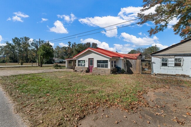
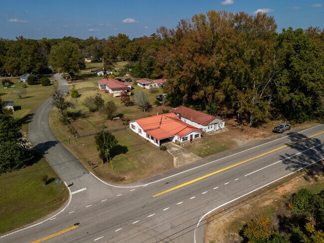
Property Record
7736 Westpoint Rd, West Point, GA 31833

NEARBY LISTINGS FOR SALE OR LEASE
-
-
View all West Point listings for sale on LoopNet.com
Property Detail
7736 Westpoint Rd
LaGrange, GA
George Winston
094-1-000-046
Troup
Sfr
Georgia
X
0.42 AC
13285C0218F
Troup County
1,814 SF
Columbus GA
DEMOGRAPHICS near 7736 Westpoint Rd
1 Mile
3 Mile
5 Mile
2024 Total Population
795
7,694
17,220
2029 Population
810
8,049
17,455
Pop Growth 2024-2029
+ 1.89%
+ 4.61%
+ 1.36%
Average Age
41
41
41
2024 Total Households
313
3,001
6,782
HH Growth 2024-2029
+ 2.24%
+ 4.93%
+ 1.50%
Median Household Inc
$48,464
$48,498
$47,321
Avg Household Size
2.40
2.50
2.40
2024 Avg HH Vehicles
2.00
2.00
2.00
Median Home Value
$97,008
$149,018
$140,427
Median Year Built
1956
1976
1973
Nearby Places
Map Layers
Map Styles
 Street
 Aerial
- Restaurants
- Banks
- Shops
- Fitness
- Groceries
PUBLIC TRANSPORTATION
AIRPORT
Columbus
DRIVE
WALK
Distance
Columbus
48 min
36.0 mi
SALE & LEASE HISTORY
LISTING DATE
SALE/LEASE

Nov 06, 2024
For Sale
Nearby Properties
Address
Land Use
TOTAL SIZE
Lot Size
Zoning
Address
Land Use
TOTAL SIZE
Lot Size
Zoning
415,440 SF
2,257.11 AC
17-I-1
Address
Land Use
TOTAL SIZE
Lot Size
Zoning
39,034.56 AC
UNAVAILABL
Address
Land Use
TOTAL SIZE
Lot Size
Zoning
517,521 SF
27.03 AC
17-I-1
Address
Land Use
TOTAL SIZE
Lot Size
Zoning
255,952 SF
2.99 AC
17-I-1
Address
Land Use
TOTAL SIZE
Lot Size
Zoning
311,435 SF
2.78 AC
17-I-1
Address
Land Use
TOTAL SIZE
Lot Size
Zoning
307,800 SF
49.87 AC
17-MXD-1
Address
Land Use
TOTAL SIZE
Lot Size
Zoning
426,400 SF
9.82 AC
17-I-1
Address
Land Use
TOTAL SIZE
Lot Size
Zoning
Address
Land Use
TOTAL SIZE
Lot Size
Zoning
132,260 SF
4.03 AC
Address
Land Use
TOTAL SIZE
Lot Size
Zoning
132,600 SF
4.63 AC
Address
Land Use
TOTAL SIZE
Lot Size
Zoning
17,098 SF
19.05 AC
17-SPLIT
Address
Land Use
TOTAL SIZE
Lot Size
Zoning
28,850 SF
6.63 AC
17-MXD-1
Address
Land Use
TOTAL SIZE
Lot Size
Zoning
70,000 SF
7.36 AC
17-I-1
Address
Land Use
TOTAL SIZE
Lot Size
Zoning
6,800 SF
10 AC
17-I-1
Address
Land Use
TOTAL SIZE
Lot Size
Zoning
160.49 AC
17-R-1
Address
Land Use
TOTAL SIZE
Lot Size
Zoning
42,369 SF
1.49 AC
17-I-1
Address
Land Use
TOTAL SIZE
Lot Size
Zoning
523.41 AC
17-MXD-1
Address
Land Use
TOTAL SIZE
Lot Size
Zoning
31,290 SF
0.75 AC
17-CGN
Address
Land Use
TOTAL SIZE
Lot Size
Zoning
57.63 AC
01-SFMD
Address
Land Use
TOTAL SIZE
Lot Size
Zoning
185.02 AC
17-R/P
Address
Land Use
TOTAL SIZE
Lot Size
Zoning
19,493 SF
15 AC
17-R-1
Address
Land Use
TOTAL SIZE
Lot Size
Zoning
106,133 SF
8.37 AC
17-I-1
Address
Land Use
TOTAL SIZE
Lot Size
Zoning
7,326 SF
4.50 AC
17-I-1
Address
Land Use
TOTAL SIZE
Lot Size
Zoning
20,409 SF
2.46 AC
17-R-1
Address
Land Use
TOTAL SIZE
Lot Size
Zoning
36,225 SF
5.74 AC
17-I-1
Address
Land Use
TOTAL SIZE
Lot Size
Zoning
18,960 SF
0.36 AC
17-CBD
Address
Land Use
TOTAL SIZE
Lot Size
Zoning
34,584 SF
3.68 AC
17-I-1
Address
Land Use
TOTAL SIZE
Lot Size
Zoning
17,852 SF
1.26 AC
17-CBD
Address
Land Use
TOTAL SIZE
Lot Size
Zoning
2,145 SF
8.59 AC
17-MXD-1
Address
Land Use
TOTAL SIZE
Lot Size
Zoning
15,711 SF
0.71 AC
17-R-1
The World's #1 Commercial Real Estate Marketplace
Connect with us
© 2025 CoStar Group
The information above has been obtained from sources believed reliable. While we do not doubt its accuracy we have not verified it and make no guarantee, warranty or representation about it. It is your responsibility to independently confirm its accuracy and completeness. Any projections, opinions, assumptions, or estimates used are for example only and do not represent the current or future performance of the property. The value of this transaction to you depends on tax and other factors which should be evaluated by your tax, financial, and legal advisors. You and your advisors should conduct a careful, independent investigation of the property to determine to your satisfaction the suitability of the property for your needs.