Property Record
7737 N El Capitan Way, Las Vegas, NV 89143

NEARBY LISTINGS FOR SALE OR LEASE
Property Detail
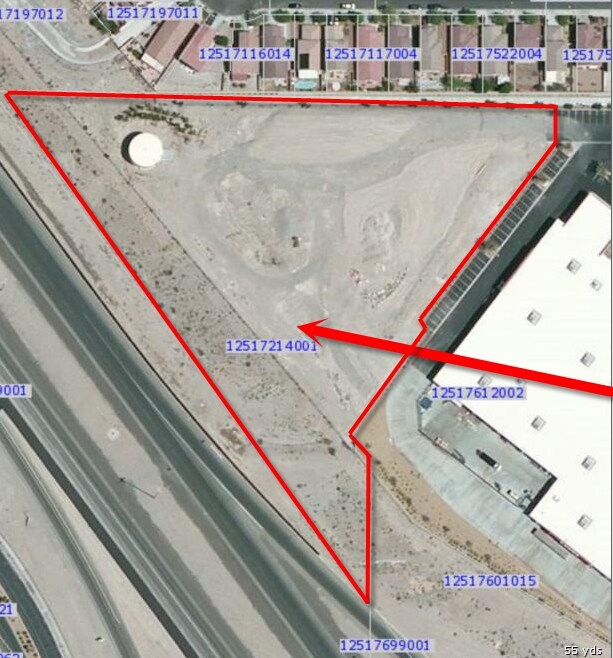
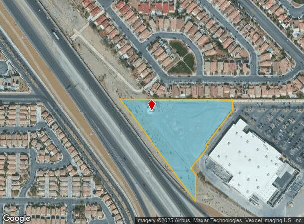
7737 N El Capitan Way
Las Vegas-Henderson-Paradise, NV
Carolines Court
125-17-214-001
CAROLINES COURT PLAT BOOK 141 PAGE 98 PT LOT 1
Commercialnec
Clark
X
Nevada
32003C1745E
1
2025
4.81 AC
2025
North Las Vegas
003316
Las Vegas
DEMOGRAPHICS near 7737 N El Capitan Way
1 Mile
3 Mile
5 Mile
2024 Total Population
27,375
112,671
196,878
2029 Population
29,384
122,109
212,825
Pop Growth 2024-2029
+ 7.34%
+ 8.38%
+ 8.10%
Average Age
35
37
39
2024 Total Households
9,677
39,479
69,294
HH Growth 2024-2029
+ 7.45%
+ 8.39%
+ 8.08%
Median Household Inc
$79,331
$93,010
$93,826
Avg Household Size
2.80
2.80
2.80
2024 Avg HH Vehicles
2.00
2.00
2.00
Median Home Value
$337,569
$416,203
$421,309
Median Year Built
2004
2005
2004
Nearby Places
Map Layers
Map Styles
 Street
 Aerial
- Restaurants
- Banks
- Shops
- Fitness
- Groceries
PUBLIC TRANSPORTATION
AIRPORT
Harry Reid International
DRIVE
WALK
Distance
Harry Reid International
33 min
22.0 mi
Freight Ports
Port of Long Beach
DRIVE
WALK
Distance
Port of Long Beach
334 min
297.5 mi
SALE & LEASE HISTORY
LISTING DATE
SALE/LEASE

Sep 24, 2016
For Sale
Jul 26, 2017
For Lease
Jul 15, 2019
For Sale
Nearby Properties
Address
Land Use
TOTAL SIZE
Lot Size
Zoning
Address
Land Use
TOTAL SIZE
Lot Size
Zoning
358,316 SF
35.74 AC
TC
Address
Land Use
TOTAL SIZE
Lot Size
Zoning
27,487 SF
697.78 AC
CV
Address
Land Use
TOTAL SIZE
Lot Size
Zoning
195,916 SF
5.91 AC
L:T-C
Address
Land Use
TOTAL SIZE
Lot Size
Zoning
6,386 SF
15.82 AC
Address
Land Use
TOTAL SIZE
Lot Size
Zoning
20,943 SF
17.99 AC
PD
Address
Land Use
TOTAL SIZE
Lot Size
Zoning
140,690 SF
37.50 AC
CV
Address
Land Use
TOTAL SIZE
Lot Size
Zoning
Address
Land Use
TOTAL SIZE
Lot Size
Zoning
25 AC
RE
Address
Land Use
TOTAL SIZE
Lot Size
Zoning
704 SF
7.49 AC
Address
Land Use
TOTAL SIZE
Lot Size
Zoning
14.92 AC
UPROS
Address
Land Use
TOTAL SIZE
Lot Size
Zoning
20 AC
CV
Address
Land Use
TOTAL SIZE
Lot Size
Zoning
43,952 SF
7.96 AC
Address
Land Use
TOTAL SIZE
Lot Size
Zoning
172,927 SF
20.78 AC
TC
Address
Land Use
TOTAL SIZE
Lot Size
Zoning
132,309 SF
12.45 AC
L:T-C
Address
Land Use
TOTAL SIZE
Lot Size
Zoning
12.42 AC
PF
Address
Land Use
TOTAL SIZE
Lot Size
Zoning
3,315 SF
13.23 AC
TC
Address
Land Use
TOTAL SIZE
Lot Size
Zoning
105,205 SF
18.86 AC
TC
Address
Land Use
TOTAL SIZE
Lot Size
Zoning
4,273 SF
16.04 AC
Address
Land Use
TOTAL SIZE
Lot Size
Zoning
4,273 SF
15.06 AC
Address
Land Use
TOTAL SIZE
Lot Size
Zoning
90,599 SF
12.14 AC
Address
Land Use
TOTAL SIZE
Lot Size
Zoning
117,088 SF
5.49 AC
Address
Land Use
TOTAL SIZE
Lot Size
Zoning
125,676 SF
11.98 AC
Address
Land Use
TOTAL SIZE
Lot Size
Zoning
2,224 SF
8.66 AC
TC
Address
Land Use
TOTAL SIZE
Lot Size
Zoning
14.99 AC
PF
Address
Land Use
TOTAL SIZE
Lot Size
Zoning
136,533 SF
13.34 AC
TC
Address
Land Use
TOTAL SIZE
Lot Size
Zoning
101,611 SF
0.67 AC
TC
Address
Land Use
TOTAL SIZE
Lot Size
Zoning
55,385 SF
4 AC
Address
Land Use
TOTAL SIZE
Lot Size
Zoning
30.06 AC
TC
Address
Land Use
TOTAL SIZE
Lot Size
Zoning
63,946 SF
10.30 AC
TC
The World's #1 Commercial Real Estate Marketplace
Connect with us
© 2025 CoStar Group
The information above has been obtained from sources believed reliable. While we do not doubt its accuracy we have not verified it and make no guarantee, warranty or representation about it. It is your responsibility to independently confirm its accuracy and completeness. Any projections, opinions, assumptions, or estimates used are for example only and do not represent the current or future performance of the property. The value of this transaction to you depends on tax and other factors which should be evaluated by your tax, financial, and legal advisors. You and your advisors should conduct a careful, independent investigation of the property to determine to your satisfaction the suitability of the property for your needs.