Property Record
7703 Northcrest Blvd, Austin, TX 78752

Current Lease Availabilities
NEARBY LISTINGS FOR SALE OR LEASE
Property Detail
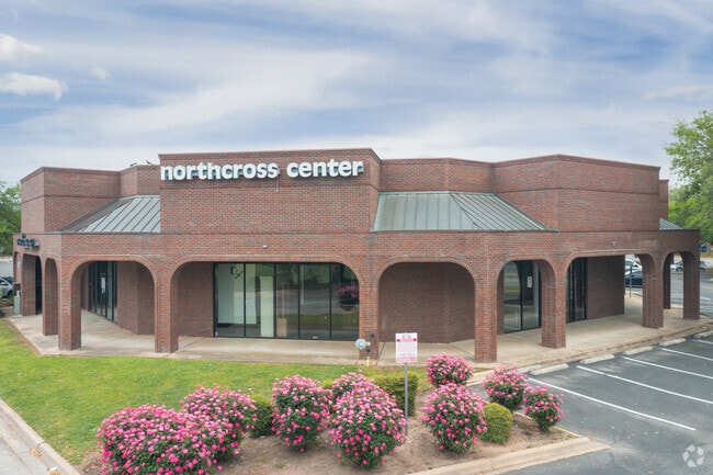
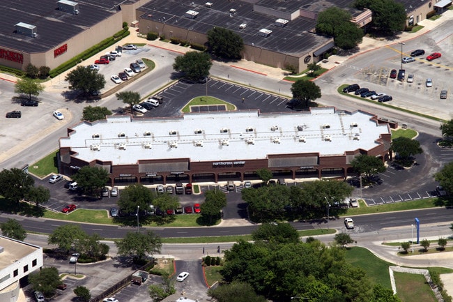
7703 Northcrest Blvd
Austin-Round Rock-San Marcos, TX
Holiday Square
235453
LOT 3H NORTHCROSS PARK
Duplex
Travis
X
Texas
48453C0455J
3h
2024
0.19 AC
2025
Central
001501
Austin
2,261 SF
DEMOGRAPHICS near 7703 Northcrest Blvd
1 Mile
3 Mile
5 Mile
2024 Total Population
16,832
138,314
328,584
2029 Population
18,232
149,797
355,923
Pop Growth 2024-2029
+ 8.32%
+ 8.30%
+ 8.32%
Average Age
39
38
37
2024 Total Households
8,415
63,181
146,604
HH Growth 2024-2029
+ 9.15%
+ 9.16%
+ 9.16%
Median Household Inc
$70,495
$70,979
$71,392
Avg Household Size
1.90
2.10
2.10
2024 Avg HH Vehicles
1.00
2.00
2.00
Median Home Value
$628,126
$629,282
$604,966
Median Year Built
1971
1980
1984
Nearby Places
Map Layers
Map Styles
 Street
 Aerial
- Restaurants
- Banks
- Shops
- Fitness
- Groceries
PUBLIC TRANSPORTATION
TRANSIT/SUBWAY
Crestview Station (550-Metro Rail Red Line - Capital Metro)
DRIVE
WALK
Distance
Crestview Station (550-Metro Rail Red Line - Capital Metro)
2 min
19 min
1.0 mi
COMMUTER RAIL
Austin (Texas Eagle - Amtrak)
DRIVE
WALK
Distance
Austin (Texas Eagle - Amtrak)
13 min
7.7 mi
AIRPORT
Austin-Bergstrom International
DRIVE
WALK
Distance
Austin-Bergstrom International
26 min
16.6 mi
Freight Ports
Calhoun Port
DRIVE
WALK
Distance
Calhoun Port
192 min
160.0 mi
Nearby Properties
Address
Land Use
TOTAL SIZE
Lot Size
Zoning
Address
Land Use
TOTAL SIZE
Lot Size
Zoning
74.69 AC
Address
Land Use
TOTAL SIZE
Lot Size
Zoning
548,399 SF
23.82 AC
Address
Land Use
TOTAL SIZE
Lot Size
Zoning
614,532 SF
66.07 AC
Address
Land Use
TOTAL SIZE
Lot Size
Zoning
1,234 SF
96.75 AC
Address
Land Use
TOTAL SIZE
Lot Size
Zoning
241,998 SF
2.42 AC
Address
Land Use
TOTAL SIZE
Lot Size
Zoning
480,823 SF
18.46 AC
Address
Land Use
TOTAL SIZE
Lot Size
Zoning
322,150 SF
3.83 AC
Address
Land Use
TOTAL SIZE
Lot Size
Zoning
432,032 SF
6.70 AC
Address
Land Use
TOTAL SIZE
Lot Size
Zoning
609,823 SF
3.33 AC
Address
Land Use
TOTAL SIZE
Lot Size
Zoning
372,075 SF
4.97 AC
Address
Land Use
TOTAL SIZE
Lot Size
Zoning
265,000 SF
1.57 AC
Address
Land Use
TOTAL SIZE
Lot Size
Zoning
346,319 SF
6.53 AC
Address
Land Use
TOTAL SIZE
Lot Size
Zoning
297,356 SF
4.32 AC
Address
Land Use
TOTAL SIZE
Lot Size
Zoning
425,200 SF
2.49 AC
Address
Land Use
TOTAL SIZE
Lot Size
Zoning
274,228 SF
4.95 AC
Address
Land Use
TOTAL SIZE
Lot Size
Zoning
276,772 SF
4.68 AC
Address
Land Use
TOTAL SIZE
Lot Size
Zoning
32.82 AC
Address
Land Use
TOTAL SIZE
Lot Size
Zoning
467,647 SF
3.54 AC
Address
Land Use
TOTAL SIZE
Lot Size
Zoning
299,957 SF
22.02 AC
Address
Land Use
TOTAL SIZE
Lot Size
Zoning
16.79 AC
Address
Land Use
TOTAL SIZE
Lot Size
Zoning
18.45 AC
Address
Land Use
TOTAL SIZE
Lot Size
Zoning
248,325 SF
2.46 AC
Address
Land Use
TOTAL SIZE
Lot Size
Zoning
16.11 AC
Address
Land Use
TOTAL SIZE
Lot Size
Zoning
555,296 SF
4.07 AC
Address
Land Use
TOTAL SIZE
Lot Size
Zoning
267,091 SF
3.90 AC
Address
Land Use
TOTAL SIZE
Lot Size
Zoning
278,429 SF
3.76 AC
Address
Land Use
TOTAL SIZE
Lot Size
Zoning
231,434 SF
1.45 AC
Address
Land Use
TOTAL SIZE
Lot Size
Zoning
263,177 SF
4.65 AC
Address
Land Use
TOTAL SIZE
Lot Size
Zoning
233,475 SF
2.94 AC
Address
Land Use
TOTAL SIZE
Lot Size
Zoning
115,640 SF
18 AC
The World's #1 Commercial Real Estate Marketplace
Connect with us
© 2026 CoStar Group
The information above has been obtained from sources believed reliable. While we do not doubt its accuracy we have not verified it and make no guarantee, warranty or representation about it. It is your responsibility to independently confirm its accuracy and completeness. Any projections, opinions, assumptions, or estimates used are for example only and do not represent the current or future performance of the property. The value of this transaction to you depends on tax and other factors which should be evaluated by your tax, financial, and legal advisors. You and your advisors should conduct a careful, independent investigation of the property to determine to your satisfaction the suitability of the property for your needs.