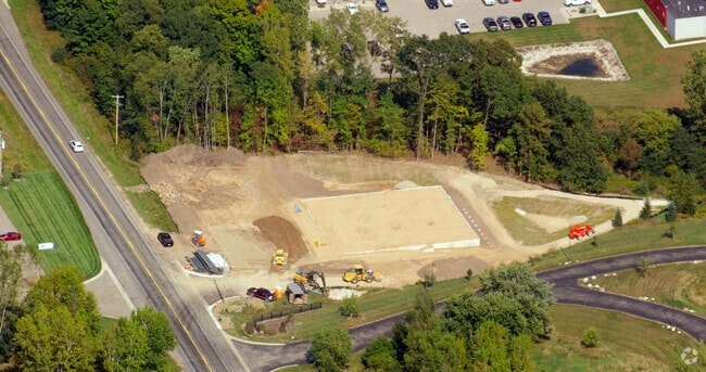
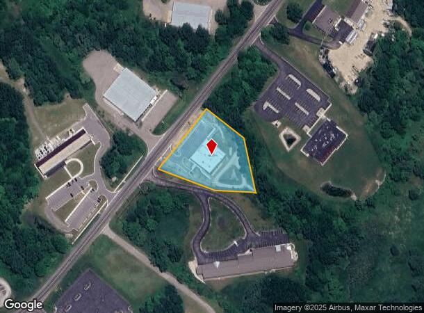
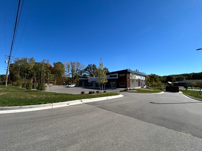
Property Record
7740 Childsdale Ave Ne, Rockford, MI 49341
Current Lease Availabilities
NEARBY LISTINGS FOR SALE OR LEASE
Property Detail
7740 Childsdale Ave Ne
41-10-02-400-015
PART OF SE 1/4 COM AT S 1/4 COR TH N 0D 46M 57S E ALONG N&S 1/4 LINE 581.63 FT TO CL OF CHILDSDALE AVE /86 FT WIDE/ TH N 67D
Commercialnec
Kent
X
Michigan
26081C0302D
2.04 AC
2024
Outlying Kent County
2025
West Michigan
011002
Grand Rapids-Wyoming, MI
DEMOGRAPHICS near 7740 Childsdale Ave Ne
1 Mile
3 Mile
5 Mile
2024 Total Population
2,308
23,375
54,717
2029 Population
2,348
23,766
55,567
Pop Growth 2024-2029
+ 1.73%
+ 1.67%
+ 1.55%
Average Age
40
40
41
2024 Total Households
871
8,530
20,382
HH Growth 2024-2029
+ 1.61%
+ 1.66%
+ 1.55%
Median Household Inc
$99,532
$101,939
$96,745
Avg Household Size
2.60
2.70
2.60
2024 Avg HH Vehicles
2.00
2.00
2.00
Median Home Value
$266,531
$294,626
$299,945
Median Year Built
1978
1991
1990
Nearby Places
Map Layers
Map Styles
 Street
 Aerial
- Restaurants
- Banks
- Shops
- Fitness
- Groceries
PUBLIC TRANSPORTATION
AIRPORT
Gerald R Ford International
DRIVE
WALK
Distance
Gerald R Ford International
37 min
20.2 mi
Freight Ports
Port Milwaukee
DRIVE
WALK
Distance
Port Milwaukee
324 min
276.9 mi
Nearby Properties
Address
Land Use
TOTAL SIZE
Lot Size
Zoning
Address
Land Use
TOTAL SIZE
Lot Size
Zoning
32.53 AC
Address
Land Use
TOTAL SIZE
Lot Size
Zoning
178,942 SF
143.48 AC
I-1
Address
Land Use
TOTAL SIZE
Lot Size
Zoning
178,942 SF
202.41 AC
I-1
Address
Land Use
TOTAL SIZE
Lot Size
Zoning
22.40 AC
Address
Land Use
TOTAL SIZE
Lot Size
Zoning
128,148 SF
42.93 AC
PUD
Address
Land Use
TOTAL SIZE
Lot Size
Zoning
17.30 AC
Address
Land Use
TOTAL SIZE
Lot Size
Zoning
4.51 AC
Address
Land Use
TOTAL SIZE
Lot Size
Zoning
Address
Land Use
TOTAL SIZE
Lot Size
Zoning
49.13 AC
Address
Land Use
TOTAL SIZE
Lot Size
Zoning
97.71 AC
Address
Land Use
TOTAL SIZE
Lot Size
Zoning
97.84 AC
Address
Land Use
TOTAL SIZE
Lot Size
Zoning
305,350 SF
49.86 AC
I-1
Address
Land Use
TOTAL SIZE
Lot Size
Zoning
113,165 SF
10.94 AC
R-3
Address
Land Use
TOTAL SIZE
Lot Size
Zoning
74,756 SF
9.86 AC
C-3
Address
Land Use
TOTAL SIZE
Lot Size
Zoning
Address
Land Use
TOTAL SIZE
Lot Size
Zoning
79.34 AC
Address
Land Use
TOTAL SIZE
Lot Size
Zoning
9.88 AC
Address
Land Use
TOTAL SIZE
Lot Size
Zoning
10.08 AC
Address
Land Use
TOTAL SIZE
Lot Size
Zoning
101,815 SF
9.23 AC
C-3
Address
Land Use
TOTAL SIZE
Lot Size
Zoning
121,183 SF
6.83 AC
I-1
Address
Land Use
TOTAL SIZE
Lot Size
Zoning
232.19 AC
Address
Land Use
TOTAL SIZE
Lot Size
Zoning
11.26 AC
Address
Land Use
TOTAL SIZE
Lot Size
Zoning
8.20 AC
R-3
Address
Land Use
TOTAL SIZE
Lot Size
Zoning
10.12 AC
Address
Land Use
TOTAL SIZE
Lot Size
Zoning
6.51 AC
Address
Land Use
TOTAL SIZE
Lot Size
Zoning
10.61 AC
Address
Land Use
TOTAL SIZE
Lot Size
Zoning
44.69 AC
Address
Land Use
TOTAL SIZE
Lot Size
Zoning
64,075 SF
11.13 AC
I-1
Address
Land Use
TOTAL SIZE
Lot Size
Zoning
18,630 SF
1.84 AC
C2
Address
Land Use
TOTAL SIZE
Lot Size
Zoning
The World's #1 Commercial Real Estate Marketplace
Connect with us
© 2025 CoStar Group
The information above has been obtained from sources believed reliable. While we do not doubt its accuracy we have not verified it and make no guarantee, warranty or representation about it. It is your responsibility to independently confirm its accuracy and completeness. Any projections, opinions, assumptions, or estimates used are for example only and do not represent the current or future performance of the property. The value of this transaction to you depends on tax and other factors which should be evaluated by your tax, financial, and legal advisors. You and your advisors should conduct a careful, independent investigation of the property to determine to your satisfaction the suitability of the property for your needs.