Property Record
0 Gate Pkwy, Jacksonville, FL 32256

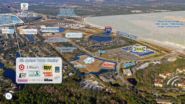
NEARBY LISTINGS FOR SALE OR LEASE
Property Detail
0 Gate Pkwy
Jacksonville, FL
Section Land
167741-0710
17-3S-28E 1.2 PT RECD O/R 21667-1114 LYING N OF O/R 18573-185
Commercialacreage
Duval
X
Florida
12031C0557H
1.20 AC
2025
Southside
2026
Jacksonville (Florida)
014426
DEMOGRAPHICS near 0 Gate Pkwy
1 mile
3 mile
5 mile
2024 Total Population
7,932
68,567
153,503
2029 Population
8,361
72,716
162,169
Pop Growth 2024-2029
+ 5.41%
+ 6.05%
+ 5.65%
Average Age
37
37
38
2024 Total Households
4,062
31,426
66,300
HH Growth 2024-2029
+ 5.51%
+ 6.26%
+ 5.78%
Median Household Inc
$72,746
$68,114
$71,741
Avg Household Size
2.00
2.00
2.20
2024 Avg HH Vehicles
2.00
2.00
2.00
Median Home Value
$297,698
$291,860
$293,836
Median Year Built
2006
2001
1998
Nearby Places
Map Layers
Map Styles
 Street
 Aerial
Transit
 Traffic
 Biking
Places
Listings with unknown addresses are not visible on the map
- Restaurants
- Banks
- Shops
- Fitness
- Groceries
PUBLIC TRANSPORTATION
AIRPORT
Jacksonville International
Drive
Walk
Distance
Jacksonville International
34 min
24.5 mi
Freight Ports
Jacksonville Port
Drive
Walk
Distance
Jacksonville Port
25 min
16.2 mi
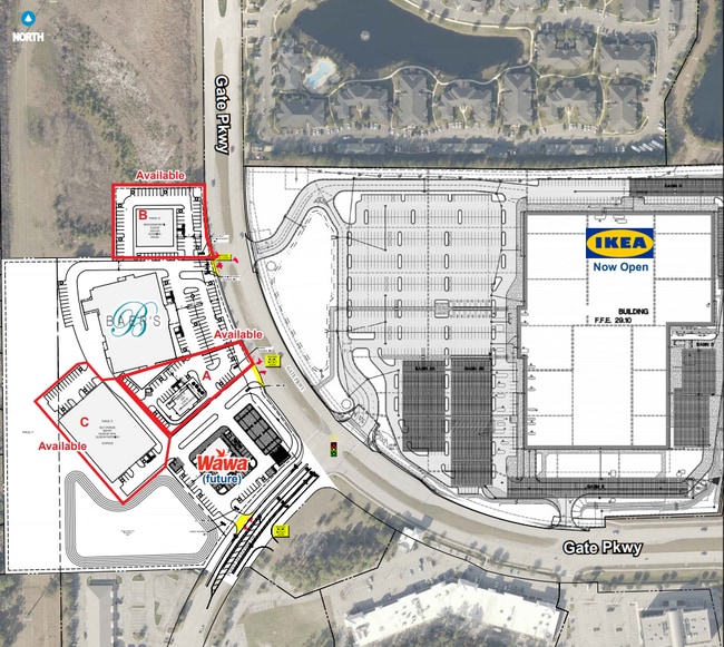
SALE & LEASE HISTORY
LISTING DATE
SALE/LEASE

Dec 04, 2019
For Lease
Nearby Properties
Address
Land Use
TOTAL SIZE
Lot Size
Zoning
Address
Land Use
TOTAL SIZE
Lot Size
Zoning
387,908 SF
32.59 AC
PUD
Address
Land Use
TOTAL SIZE
Lot Size
Zoning
297,275 SF
38.30 AC
PUD
Address
Land Use
TOTAL SIZE
Lot Size
Zoning
1,037,304 SF
103.91 AC
PUD
Address
Land Use
TOTAL SIZE
Lot Size
Zoning
1,159,855 SF
89.44 AC
RMD-D
Address
Land Use
TOTAL SIZE
Lot Size
Zoning
1,013,318 SF
131.30 AC
PUD
Address
Land Use
TOTAL SIZE
Lot Size
Zoning
449,658 SF
8.78 AC
PUD
Address
Land Use
TOTAL SIZE
Lot Size
Zoning
251,691 SF
17.51 AC
PUD
Address
Land Use
TOTAL SIZE
Lot Size
Zoning
371,068 SF
19.22 AC
PUD
Address
Land Use
TOTAL SIZE
Lot Size
Zoning
283,724 SF
28.50 AC
PUD
Address
Land Use
TOTAL SIZE
Lot Size
Zoning
293,072 SF
16.52 AC
PUD
Address
Land Use
TOTAL SIZE
Lot Size
Zoning
444,532 SF
27.22 AC
PUD
Address
Land Use
TOTAL SIZE
Lot Size
Zoning
186,482 SF
33.57 AC
PUD
Address
Land Use
TOTAL SIZE
Lot Size
Zoning
223,939 SF
13.28 AC
PUD
Address
Land Use
TOTAL SIZE
Lot Size
Zoning
209,436 SF
14.38 AC
PUD
Address
Land Use
TOTAL SIZE
Lot Size
Zoning
242,868 SF
13.45 AC
PUD
Address
Land Use
TOTAL SIZE
Lot Size
Zoning
345,841 SF
15.16 AC
PUD
Address
Land Use
TOTAL SIZE
Lot Size
Zoning
216,370 SF
10.02 AC
PUD
Address
Land Use
TOTAL SIZE
Lot Size
Zoning
279,038 SF
28.39 AC
PUD
Address
Land Use
TOTAL SIZE
Lot Size
Zoning
954,167 SF
56.79 AC
PUD
Address
Land Use
TOTAL SIZE
Lot Size
Zoning
262,453 SF
17.09 AC
PUD
Address
Land Use
TOTAL SIZE
Lot Size
Zoning
475,463 SF
37.20 AC
PUD
Address
Land Use
TOTAL SIZE
Lot Size
Zoning
255,951 SF
5.58 AC
PUD
Address
Land Use
TOTAL SIZE
Lot Size
Zoning
306,416 SF
12.27 AC
PUD
Address
Land Use
TOTAL SIZE
Lot Size
Zoning
341,849 SF
15 AC
PUD
Address
Land Use
TOTAL SIZE
Lot Size
Zoning
217,557 SF
14.72 AC
PUD
Address
Land Use
TOTAL SIZE
Lot Size
Zoning
371,698 SF
12.86 AC
PUD
Address
Land Use
TOTAL SIZE
Lot Size
Zoning
329,810 SF
33.39 AC
PUD
Address
Land Use
TOTAL SIZE
Lot Size
Zoning
446,326 SF
23.68 AC
RMD-D
Address
Land Use
TOTAL SIZE
Lot Size
Zoning
258,174 SF
10.55 AC
PUD
Address
Land Use
TOTAL SIZE
Lot Size
Zoning
383,228 SF
40.69 AC
PUD
The World's #1 Commercial Real Estate Marketplace
Connect with us
© 2026 CoStar Group
The information above has been obtained from sources believed reliable. While we do not doubt its accuracy we have not verified it and make no guarantee, warranty or representation about it. It is your responsibility to independently confirm its accuracy and completeness. Any projections, opinions, assumptions, or estimates used are for example only and do not represent the current or future performance of the property. The value of this transaction to you depends on tax and other factors which should be evaluated by your tax, financial, and legal advisors. You and your advisors should conduct a careful, independent investigation of the property to determine to your satisfaction the suitability of the property for your needs.