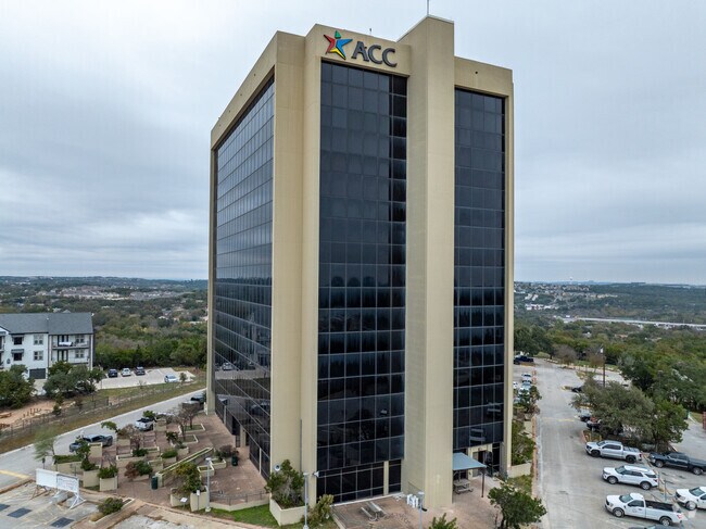
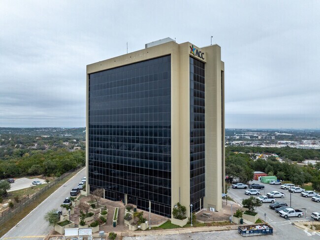
Property Record
7748 Highway 290 W, Austin, TX 78736

NEARBY LISTINGS FOR SALE OR LEASE
Property Detail
7748 Highway 290 W
Austin-Round Rock, TX
Angerman Subd
315292
8.8936AC OF LOT 1 ANGERMAN SUBD
Officebuilding
Travis
X
Texas
48453C0560J
1
0
8.89 AC
2025
Southwest
033000
Austin
107,654 SF
DEMOGRAPHICS near 7748 Highway 290 W
1 Mile
3 Mile
5 Mile
2024 Total Population
8,600
60,217
127,371
2029 Population
9,225
63,789
135,256
Pop Growth 2024-2029
+ 7.27%
+ 5.93%
+ 6.19%
Average Age
40
40
40
2024 Total Households
3,724
24,819
52,134
HH Growth 2024-2029
+ 8.30%
+ 6.87%
+ 7.03%
Median Household Inc
$102,491
$114,153
$113,633
Avg Household Size
2.30
2.40
2.40
2024 Avg HH Vehicles
2.00
2.00
2.00
Median Home Value
$455,168
$509,998
$541,149
Median Year Built
1999
1997
1995
Nearby Places
Map Layers
Map Styles
 Street
 Aerial
- Restaurants
- Banks
- Shops
- Fitness
- Groceries
PUBLIC TRANSPORTATION
COMMUTER RAIL
Austin (Texas Eagle - Amtrak)
DRIVE
WALK
Distance
Austin (Texas Eagle - Amtrak)
16 min
9.8 mi
AIRPORT
Austin-Bergstrom International
DRIVE
WALK
Distance
Austin-Bergstrom International
30 min
16.6 mi
Freight Ports
Calhoun Port
DRIVE
WALK
Distance
Calhoun Port
195 min
160.1 mi
Nearby Properties
Address
Land Use
TOTAL SIZE
Lot Size
Zoning
Address
Land Use
TOTAL SIZE
Lot Size
Zoning
881,940 SF
80.11 AC
Address
Land Use
TOTAL SIZE
Lot Size
Zoning
881,498 SF
58.79 AC
Address
Land Use
TOTAL SIZE
Lot Size
Zoning
617,120 SF
53.40 AC
Address
Land Use
TOTAL SIZE
Lot Size
Zoning
456,600 SF
44.89 AC
Address
Land Use
TOTAL SIZE
Lot Size
Zoning
474,907 SF
36.94 AC
Address
Land Use
TOTAL SIZE
Lot Size
Zoning
422,810 SF
46.50 AC
Address
Land Use
TOTAL SIZE
Lot Size
Zoning
359,339 SF
23.59 AC
Address
Land Use
TOTAL SIZE
Lot Size
Zoning
432,404 SF
37.29 AC
Address
Land Use
TOTAL SIZE
Lot Size
Zoning
392,093 SF
24.02 AC
Address
Land Use
TOTAL SIZE
Lot Size
Zoning
267,224 SF
56.90 AC
Address
Land Use
TOTAL SIZE
Lot Size
Zoning
400,301 SF
22.65 AC
Address
Land Use
TOTAL SIZE
Lot Size
Zoning
355,651 SF
31.86 AC
Address
Land Use
TOTAL SIZE
Lot Size
Zoning
286,988 SF
27.73 AC
Address
Land Use
TOTAL SIZE
Lot Size
Zoning
258,600 SF
36.81 AC
Address
Land Use
TOTAL SIZE
Lot Size
Zoning
324,135 SF
53.12 AC
Address
Land Use
TOTAL SIZE
Lot Size
Zoning
267,928 SF
18.13 AC
Address
Land Use
TOTAL SIZE
Lot Size
Zoning
339,456 SF
32.70 AC
Address
Land Use
TOTAL SIZE
Lot Size
Zoning
253,902 SF
28.21 AC
Address
Land Use
TOTAL SIZE
Lot Size
Zoning
278,740 SF
44.30 AC
Address
Land Use
TOTAL SIZE
Lot Size
Zoning
240,640 SF
14.36 AC
Address
Land Use
TOTAL SIZE
Lot Size
Zoning
262,421 SF
33.65 AC
Address
Land Use
TOTAL SIZE
Lot Size
Zoning
126.95 AC
Address
Land Use
TOTAL SIZE
Lot Size
Zoning
150,975 SF
35.79 AC
Address
Land Use
TOTAL SIZE
Lot Size
Zoning
295,322 SF
23.02 AC
Address
Land Use
TOTAL SIZE
Lot Size
Zoning
183,198 SF
23 AC
Address
Land Use
TOTAL SIZE
Lot Size
Zoning
267,156 SF
45.30 AC
Address
Land Use
TOTAL SIZE
Lot Size
Zoning
82,326 SF
53.78 AC
Address
Land Use
TOTAL SIZE
Lot Size
Zoning
199,816 SF
20.10 AC
Address
Land Use
TOTAL SIZE
Lot Size
Zoning
1,759,639 SF
153.30 AC
Address
Land Use
TOTAL SIZE
Lot Size
Zoning
250,211 SF
21.60 AC
The World's #1 Commercial Real Estate Marketplace
Connect with us
© 2025 CoStar Group
The information above has been obtained from sources believed reliable. While we do not doubt its accuracy we have not verified it and make no guarantee, warranty or representation about it. It is your responsibility to independently confirm its accuracy and completeness. Any projections, opinions, assumptions, or estimates used are for example only and do not represent the current or future performance of the property. The value of this transaction to you depends on tax and other factors which should be evaluated by your tax, financial, and legal advisors. You and your advisors should conduct a careful, independent investigation of the property to determine to your satisfaction the suitability of the property for your needs.