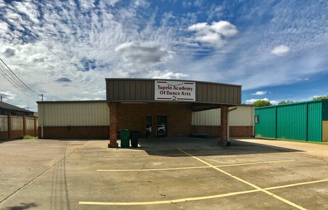
Property Record
775 Poplarville St, Tupelo, MS 38801

NEARBY LISTINGS FOR SALE OR LEASE
Property Detail
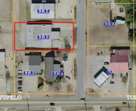
775 Poplarville St
078H-27-063-02
LOT SE1/4 SE1/4
Officebuilding
Lee
X
Mississippi
28081C0144F
0.44 AC
0
Tupelo/North Area
2025
Other Market Areas
950601
Tupelo, MS
6,450 SF
DEMOGRAPHICS near 775 Poplarville St
1 Mile
3 Mile
5 Mile
2024 Total Population
3,295
26,503
39,658
2029 Population
3,194
26,531
39,575
Pop Growth 2024-2029
(3.07%)
+ 0.11%
(0.21%)
Average Age
39
38
38
2024 Total Households
1,401
10,945
16,228
HH Growth 2024-2029
(3.43%)
+ 0.09%
(0.18%)
Median Household Inc
$47,031
$62,669
$58,228
Avg Household Size
2.20
2.30
2.30
2024 Avg HH Vehicles
2.00
2.00
2.00
Median Home Value
$150,434
$187,487
$185,900
Median Year Built
1980
1982
1983
Nearby Places
Map Layers
Map Styles
 Street
 Aerial
- Restaurants
- Banks
- Shops
- Fitness
- Groceries
SALE & LEASE HISTORY
LISTING DATE
SALE/LEASE

Oct 26, 2018
For Sale
Jun 27, 2019
For Sale
Nearby Properties
Address
Land Use
TOTAL SIZE
Lot Size
Zoning
Address
Land Use
TOTAL SIZE
Lot Size
Zoning
154,645 SF
15.58 AC
Address
Land Use
TOTAL SIZE
Lot Size
Zoning
3,432 SF
30.50 AC
Address
Land Use
TOTAL SIZE
Lot Size
Zoning
30,716 SF
5.40 AC
Address
Land Use
TOTAL SIZE
Lot Size
Zoning
66,758 SF
17.10 AC
Address
Land Use
TOTAL SIZE
Lot Size
Zoning
59,200 SF
4.90 AC
Address
Land Use
TOTAL SIZE
Lot Size
Zoning
56,097 SF
14.80 AC
Address
Land Use
TOTAL SIZE
Lot Size
Zoning
47,219 SF
11.90 AC
Address
Land Use
TOTAL SIZE
Lot Size
Zoning
20,368 SF
1.03 AC
Address
Land Use
TOTAL SIZE
Lot Size
Zoning
55,180 SF
5.90 AC
Address
Land Use
TOTAL SIZE
Lot Size
Zoning
133,524 SF
16.80 AC
Address
Land Use
TOTAL SIZE
Lot Size
Zoning
241,288 SF
36.40 AC
Address
Land Use
TOTAL SIZE
Lot Size
Zoning
23,968 SF
1.88 AC
Address
Land Use
TOTAL SIZE
Lot Size
Zoning
21,608 SF
4.80 AC
Address
Land Use
TOTAL SIZE
Lot Size
Zoning
40,199 SF
1.80 AC
Address
Land Use
TOTAL SIZE
Lot Size
Zoning
180,994 SF
20.70 AC
Address
Land Use
TOTAL SIZE
Lot Size
Zoning
77,613 SF
6.47 AC
Address
Land Use
TOTAL SIZE
Lot Size
Zoning
12,888 SF
13 AC
Address
Land Use
TOTAL SIZE
Lot Size
Zoning
7,968 SF
15.50 AC
Address
Land Use
TOTAL SIZE
Lot Size
Zoning
106,964 SF
24.80 AC
Address
Land Use
TOTAL SIZE
Lot Size
Zoning
17,446 SF
2.25 AC
Address
Land Use
TOTAL SIZE
Lot Size
Zoning
33,900 SF
6.30 AC
Address
Land Use
TOTAL SIZE
Lot Size
Zoning
11,957 SF
1.95 AC
Address
Land Use
TOTAL SIZE
Lot Size
Zoning
17,631 SF
0.49 AC
Address
Land Use
TOTAL SIZE
Lot Size
Zoning
15,998 SF
2.30 AC
Address
Land Use
TOTAL SIZE
Lot Size
Zoning
5,471 SF
0.77 AC
Address
Land Use
TOTAL SIZE
Lot Size
Zoning
64,854 SF
7.60 AC
Address
Land Use
TOTAL SIZE
Lot Size
Zoning
61,600 SF
12.80 AC
Address
Land Use
TOTAL SIZE
Lot Size
Zoning
7,433 SF
14.20 AC
Address
Land Use
TOTAL SIZE
Lot Size
Zoning
7,450 SF
2.20 AC
The World's #1 Commercial Real Estate Marketplace
Connect with us
© 2026 CoStar Group
The information above has been obtained from sources believed reliable. While we do not doubt its accuracy we have not verified it and make no guarantee, warranty or representation about it. It is your responsibility to independently confirm its accuracy and completeness. Any projections, opinions, assumptions, or estimates used are for example only and do not represent the current or future performance of the property. The value of this transaction to you depends on tax and other factors which should be evaluated by your tax, financial, and legal advisors. You and your advisors should conduct a careful, independent investigation of the property to determine to your satisfaction the suitability of the property for your needs.