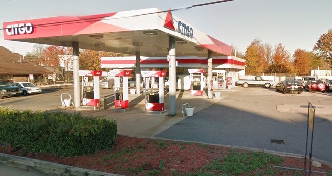
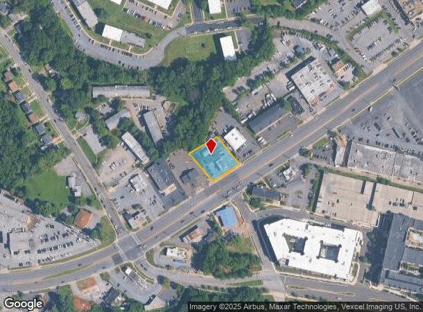
Property Record
7750 Annapolis Rd, Lanham, MD 20706
NEARBY LISTINGS FOR SALE OR LEASE
Property Detail
7750 Annapolis Rd
Washington-Arlington-Alexandria, DC-VA-MD-WV
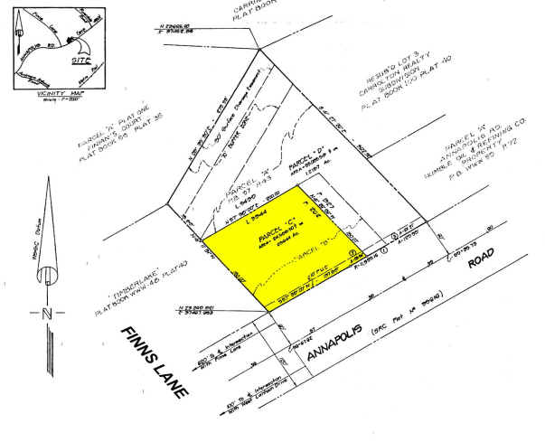
Parcel C And D A Resubdivision Of Parcel
20-2267847
PARCEL C
Servicestation
Prince George's
X
Maryland
24033C0134E
c
2024
0.56 AC
2025
Lanham
803613
Washington, DC
1,860 SF
DEMOGRAPHICS near 7750 Annapolis Rd
1 Mile
3 Mile
5 Mile
2024 Total Population
16,562
146,558
344,149
2029 Population
16,077
142,950
335,226
Pop Growth 2024-2029
(2.93%)
(2.46%)
(2.59%)
Average Age
37
38
38
2024 Total Households
5,612
46,341
116,093
HH Growth 2024-2029
(2.73%)
(2.57%)
(2.81%)
Median Household Inc
$70,654
$79,510
$80,123
Avg Household Size
2.90
3.10
2.80
2024 Avg HH Vehicles
2.00
2.00
2.00
Median Home Value
$319,020
$347,979
$373,428
Median Year Built
1966
1968
1971
Nearby Places
Map Layers
Map Styles
 Street
 Aerial
- Restaurants
- Banks
- Shops
- Fitness
- Groceries
PUBLIC TRANSPORTATION
COMMUTER RAIL
New Carrollton (Penn Line - Maryland Area Regional Commuter Trains (The MARC))
DRIVE
WALK
Distance
New Carrollton (Penn Line - Maryland Area Regional Commuter Trains (The MARC))
3 min
11 min
0.5 mi
Seabrook (Penn Line - Maryland Area Regional Commuter Trains (The MARC))
DRIVE
WALK
Distance
Seabrook (Penn Line - Maryland Area Regional Commuter Trains (The MARC))
6 min
2.4 mi
AIRPORT
Ronald Reagan Washington Ntl
DRIVE
WALK
Distance
Ronald Reagan Washington Ntl
26 min
16.3 mi
Baltimore/Washington International Thurgood Marshall
DRIVE
WALK
Distance
Baltimore/Washington International Thurgood Marshall
30 min
23.4 mi
Washington Dulles International
DRIVE
WALK
Distance
Washington Dulles International
69 min
46.2 mi
SALE & LEASE HISTORY
LISTING DATE
SALE/LEASE

Sep 24, 2016
For Sale
Nearby Properties
Address
Land Use
TOTAL SIZE
Lot Size
Zoning
Address
Land Use
TOTAL SIZE
Lot Size
Zoning
1,631,415 SF
24.33 AC
RTOHC
Address
Land Use
TOTAL SIZE
Lot Size
Zoning
944,105 SF
23.09 AC
CGO
Address
Land Use
TOTAL SIZE
Lot Size
Zoning
413,915 SF
39.86 AC
IE
Address
Land Use
TOTAL SIZE
Lot Size
Zoning
337,216 SF
1.18 AC
RTOHC
Address
Land Use
TOTAL SIZE
Lot Size
Zoning
337,500 SF
12.48 AC
RTOLE
Address
Land Use
TOTAL SIZE
Lot Size
Zoning
290,728 SF
29.27 AC
RSF95
Address
Land Use
TOTAL SIZE
Lot Size
Zoning
395,538 SF
9.89 AC
RTOLE
Address
Land Use
TOTAL SIZE
Lot Size
Zoning
1,082,460 SF
9.28 AC
RTOHC
Address
Land Use
TOTAL SIZE
Lot Size
Zoning
6.39 AC
RMF48
Address
Land Use
TOTAL SIZE
Lot Size
Zoning
264,093 SF
22.74 AC
CGO
Address
Land Use
TOTAL SIZE
Lot Size
Zoning
27.07 AC
RMF20
Address
Land Use
TOTAL SIZE
Lot Size
Zoning
2.35 AC
RTOHC
Address
Land Use
TOTAL SIZE
Lot Size
Zoning
305,375 SF
39.83 AC
RSF65
Address
Land Use
TOTAL SIZE
Lot Size
Zoning
327,240 SF
1.72 AC
RTOHC
Address
Land Use
TOTAL SIZE
Lot Size
Zoning
14.85 AC
RMF20
Address
Land Use
TOTAL SIZE
Lot Size
Zoning
182,907 SF
39.78 AC
RR
Address
Land Use
TOTAL SIZE
Lot Size
Zoning
256,896 SF
34.96 AC
RSF65
Address
Land Use
TOTAL SIZE
Lot Size
Zoning
368,038 SF
12.87 AC
IE
Address
Land Use
TOTAL SIZE
Lot Size
Zoning
194,850 SF
8.90 AC
LTOE
Address
Land Use
TOTAL SIZE
Lot Size
Zoning
17.68 AC
RMF20
Address
Land Use
TOTAL SIZE
Lot Size
Zoning
2.09 AC
RTOHC
Address
Land Use
TOTAL SIZE
Lot Size
Zoning
218,628 SF
1.45 AC
RTOHC
Address
Land Use
TOTAL SIZE
Lot Size
Zoning
300,000 SF
2.82 AC
RTOHC
Address
Land Use
TOTAL SIZE
Lot Size
Zoning
169,431 SF
43.81 AC
CGO
Address
Land Use
TOTAL SIZE
Lot Size
Zoning
108,864 SF
0.91 AC
RTOHC
Address
Land Use
TOTAL SIZE
Lot Size
Zoning
226,810 SF
21.40 AC
RSF65
Address
Land Use
TOTAL SIZE
Lot Size
Zoning
123,464 SF
8.03 AC
RTOLE
Address
Land Use
TOTAL SIZE
Lot Size
Zoning
2.35 AC
RTOHC
Address
Land Use
TOTAL SIZE
Lot Size
Zoning
10.81 AC
RMF48
Address
Land Use
TOTAL SIZE
Lot Size
Zoning
57,288 SF
6.94 AC
TACE
The World's #1 Commercial Real Estate Marketplace
Connect with us
© 2026 CoStar Group
The information above has been obtained from sources believed reliable. While we do not doubt its accuracy we have not verified it and make no guarantee, warranty or representation about it. It is your responsibility to independently confirm its accuracy and completeness. Any projections, opinions, assumptions, or estimates used are for example only and do not represent the current or future performance of the property. The value of this transaction to you depends on tax and other factors which should be evaluated by your tax, financial, and legal advisors. You and your advisors should conduct a careful, independent investigation of the property to determine to your satisfaction the suitability of the property for your needs.