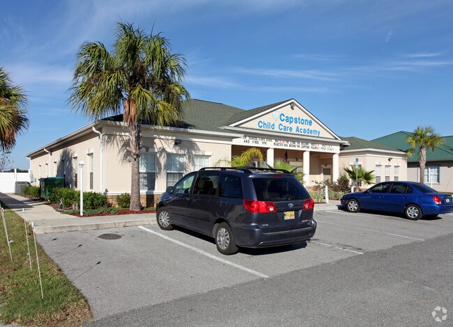
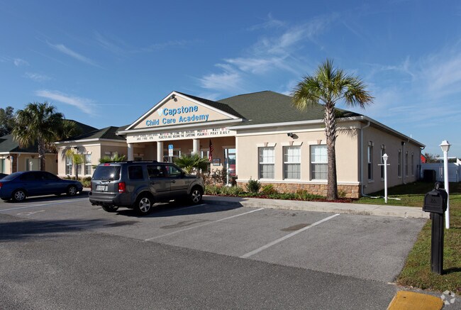
Property Record
7750 Sw 60Th Ave, Ocala, FL 34476

Save to a Folder
{{folder.Name}}
{{folder.ListingIds.length}} Properties
{{folder.ListingIds.length}} Property
Create a New Folder
Property Detail
7750 Sw 60Th Ave
35497-005-08
SEC 08 TWP 16 RGE 21 PLAT BOOK 008 PAGE 015 JASMINE WALK FIRST ADD LOTS 6.7.8
Daycare
Marion
PUD
Florida
B and X Area of moderate flood hazard, usually the area between the limits of the 100-year and 500-year floods.
6
2025
1.53 AC
2025
Outlying Marion County
001010
Ocala
15,614 SF
Ocala, FL
NEARBY LISTINGS FOR SALE OR LEASE
-
-
View all Ocala listings for sale on LoopNet.com
DEMOGRAPHICS near 7750 Sw 60Th Ave
1 mile
3 mile
5 mile
2025 Total Population
3,874
30,638
72,212
2030 Population
4,449
34,746
81,686
Pop Growth 2025-2030
+ 14.84%
+ 13.41%
+ 13.12%
Average Age
49
50
53
2025 Total Households
1,669
13,565
33,867
HH Growth 2025-2030
+ 15.10%
+ 13.66%
+ 13.38%
Median Household Inc
$76,220
$65,930
$62,496
Avg Household Size
2.30
2.20
2.10
2025 Avg HH Vehicles
2.00
2.00
2.00
Median Home Value
$308,132
$295,396
$302,623
Median Year Built
2003
2001
1998
Nearby Places
Map Layers
Map Styles
 Street
 Aerial
Layers
 Traffic
 Biking
Places
Listings with unknown addresses are not visible on the map
- Restaurants
- Banks
- Shops
- Fitness
- Groceries
Nearby Properties
Address
Land Use
TOTAL SIZE
Lot Size
Zoning
Address
Land Use
TOTAL SIZE
Lot Size
Zoning
156,201 SF
36.77 AC
INST
Address
Land Use
TOTAL SIZE
Lot Size
Zoning
283,913 SF
24.22 AC
B2
Address
Land Use
TOTAL SIZE
Lot Size
Zoning
120,296 SF
35.67 AC
PD
Address
Land Use
TOTAL SIZE
Lot Size
Zoning
192,480 SF
23.19 AC
R3
Address
Land Use
TOTAL SIZE
Lot Size
Zoning
324,262 SF
40.79 AC
SC
Address
Land Use
TOTAL SIZE
Lot Size
Zoning
189,662 SF
25.54 AC
B2
Address
Land Use
TOTAL SIZE
Lot Size
Zoning
87,034 SF
14.45 AC
R3
Address
Land Use
TOTAL SIZE
Lot Size
Zoning
380,749 SF
40.05 AC
PUD
Address
Land Use
TOTAL SIZE
Lot Size
Zoning
124,557 SF
39.04 AC
GU
Address
Land Use
TOTAL SIZE
Lot Size
Zoning
304,259 SF
31.62 AC
PUD
Address
Land Use
TOTAL SIZE
Lot Size
Zoning
59,706 SF
10.01 AC
PD
Address
Land Use
TOTAL SIZE
Lot Size
Zoning
96,094 SF
13.66 AC
B2
Address
Land Use
TOTAL SIZE
Lot Size
Zoning
62,253 SF
6.52 AC
PUD
Address
Land Use
TOTAL SIZE
Lot Size
Zoning
95,496 SF
25.25 AC
R3
Address
Land Use
TOTAL SIZE
Lot Size
Zoning
74,928 SF
7.80 AC
PUD
Address
Land Use
TOTAL SIZE
Lot Size
Zoning
18,035 SF
3.33 AC
B2
Address
Land Use
TOTAL SIZE
Lot Size
Zoning
68,372 SF
21.78 AC
B4
Address
Land Use
TOTAL SIZE
Lot Size
Zoning
44,276 SF
5 AC
O1
Address
Land Use
TOTAL SIZE
Lot Size
Zoning
139,728 SF
22.86 AC
B4
Address
Land Use
TOTAL SIZE
Lot Size
Zoning
84,004 SF
9.77 AC
SC
Address
Land Use
TOTAL SIZE
Lot Size
Zoning
65,060 SF
11.90 AC
B2
Address
Land Use
TOTAL SIZE
Lot Size
Zoning
23,783 SF
3.27 AC
B2
Address
Land Use
TOTAL SIZE
Lot Size
Zoning
56,605 SF
4.12 AC
B2
Address
Land Use
TOTAL SIZE
Lot Size
Zoning
77,877 SF
13.38 AC
B2
Address
Land Use
TOTAL SIZE
Lot Size
Zoning
128,206 SF
11.38 AC
SC
Address
Land Use
TOTAL SIZE
Lot Size
Zoning
42,673 SF
13.72 AC
A1
Address
Land Use
TOTAL SIZE
Lot Size
Zoning
11,837 SF
3.99 AC
OP
Address
Land Use
TOTAL SIZE
Lot Size
Zoning
42,159 SF
5.95 AC
B2
Address
Land Use
TOTAL SIZE
Lot Size
Zoning
118,702 SF
17.93 AC
M1
Address
Land Use
TOTAL SIZE
Lot Size
Zoning
20,982 SF
4 AC
O1
The World's #1 Commercial Real Estate Marketplace
Connect with us
© 2026 CoStar Group
The information above has been obtained from sources believed reliable. While we do not doubt its accuracy we have not verified it and make no guarantee, warranty or representation about it. It is your responsibility to independently confirm its accuracy and completeness. Any projections, opinions, assumptions, or estimates used are for example only and do not represent the current or future performance of the property. The value of this transaction to you depends on tax and other factors which should be evaluated by your tax, financial, and legal advisors. You and your advisors should conduct a careful, independent investigation of the property to determine to your satisfaction the suitability of the property for your needs.