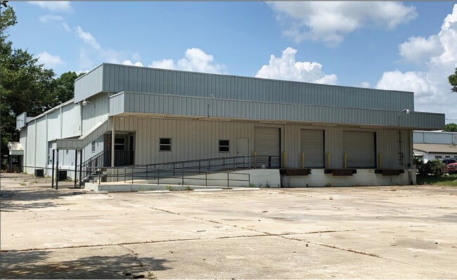
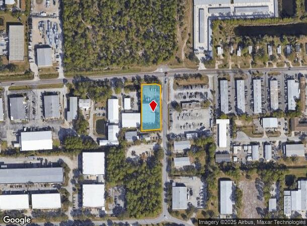
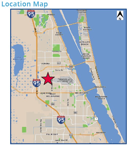
Property Record
7755 Ellis Rd, Melbourne, FL 32904
Current Lease Availabilities
NEARBY LISTINGS FOR SALE OR LEASE
Property Detail
7755 Ellis Rd
Palm Bay-Melbourne-Titusville, FL
Eau Gallie Suburbs (****Warning This Pla
27-36-36-00-00268.0-0000.00
PART OF NE 1/4 OF NW 1/4 AS DES IN ORB 2583 PG 1585
Truckterminal
Brevard
X
Florida
12009C0581G
9
2024
0.94 AC
2025
Brevard County
064601
Orlando
13,475 SF
DEMOGRAPHICS near 7755 Ellis Rd
1 Mile
3 Mile
5 Mile
2024 Total Population
2,847
42,462
118,095
2029 Population
3,111
46,324
129,206
Pop Growth 2024-2029
+ 9.27%
+ 9.10%
+ 9.41%
Average Age
46
43
44
2024 Total Households
1,274
17,304
50,146
HH Growth 2024-2029
+ 8.95%
+ 8.91%
+ 9.23%
Median Household Inc
$79,833
$69,226
$62,606
Avg Household Size
2.10
2.30
2.20
2024 Avg HH Vehicles
2.00
2.00
2.00
Median Home Value
$245,913
$252,919
$250,635
Median Year Built
1985
1983
1986
Nearby Places
Map Layers
Map Styles
 Street
 Aerial
- Restaurants
- Banks
- Shops
- Fitness
- Groceries
PUBLIC TRANSPORTATION
AIRPORT
Melbourne Orlando International
DRIVE
WALK
Distance
Melbourne Orlando International
9 min
3.6 mi
Freight Ports
Port Canaveral
DRIVE
WALK
Distance
Port Canaveral
44 min
34.8 mi
Nearby Properties
Address
Land Use
TOTAL SIZE
Lot Size
Zoning
Address
Land Use
TOTAL SIZE
Lot Size
Zoning
433,669 SF
21.22 AC
AU
Address
Land Use
TOTAL SIZE
Lot Size
Zoning
506,643 SF
80 AC
RA
Address
Land Use
TOTAL SIZE
Lot Size
Zoning
425,167 SF
43.33 AC
Address
Land Use
TOTAL SIZE
Lot Size
Zoning
265,272 SF
21.17 AC
M1
Address
Land Use
TOTAL SIZE
Lot Size
Zoning
265,062 SF
14.75 AC
M1
Address
Land Use
TOTAL SIZE
Lot Size
Zoning
384,430 SF
33.07 AC
R2
Address
Land Use
TOTAL SIZE
Lot Size
Zoning
389,175 SF
12.18 AC
Address
Land Use
TOTAL SIZE
Lot Size
Zoning
387,843 SF
27.19 AC
R3
Address
Land Use
TOTAL SIZE
Lot Size
Zoning
197,734 SF
27.99 AC
M1
Address
Land Use
TOTAL SIZE
Lot Size
Zoning
261,552 SF
23.21 AC
R2
Address
Land Use
TOTAL SIZE
Lot Size
Zoning
268,487 SF
20.08 AC
RA
Address
Land Use
TOTAL SIZE
Lot Size
Zoning
280,518 SF
13.88 AC
Address
Land Use
TOTAL SIZE
Lot Size
Zoning
296,436 SF
28.05 AC
Address
Land Use
TOTAL SIZE
Lot Size
Zoning
542,262 SF
51.88 AC
CP
Address
Land Use
TOTAL SIZE
Lot Size
Zoning
201,325 SF
11.41 AC
Address
Land Use
TOTAL SIZE
Lot Size
Zoning
207,405 SF
28.05 AC
R26
Address
Land Use
TOTAL SIZE
Lot Size
Zoning
226,121 SF
17.73 AC
Address
Land Use
TOTAL SIZE
Lot Size
Zoning
225,020 SF
24.25 AC
Address
Land Use
TOTAL SIZE
Lot Size
Zoning
74,716 SF
366.45 AC
M1
Address
Land Use
TOTAL SIZE
Lot Size
Zoning
196,130 SF
16 AC
Address
Land Use
TOTAL SIZE
Lot Size
Zoning
205,564 SF
14.56 AC
M1
Address
Land Use
TOTAL SIZE
Lot Size
Zoning
198,876 SF
64.32 AC
M1
Address
Land Use
TOTAL SIZE
Lot Size
Zoning
175,610 SF
10.01 AC
CCP(15)
Address
Land Use
TOTAL SIZE
Lot Size
Zoning
146,527 SF
42.12 AC
M-1
Address
Land Use
TOTAL SIZE
Lot Size
Zoning
248,019 SF
12.22 AC
P1
Address
Land Use
TOTAL SIZE
Lot Size
Zoning
672 SF
261.50 AC
M1
Address
Land Use
TOTAL SIZE
Lot Size
Zoning
161,528 SF
13.23 AC
CP
Address
Land Use
TOTAL SIZE
Lot Size
Zoning
353,747 SF
54.66 AC
M1
Address
Land Use
TOTAL SIZE
Lot Size
Zoning
2,128 SF
6.92 AC
P1
Address
Land Use
TOTAL SIZE
Lot Size
Zoning
239,767 SF
24.47 AC
M1
The World's #1 Commercial Real Estate Marketplace
Connect with us
© 2025 CoStar Group
The information above has been obtained from sources believed reliable. While we do not doubt its accuracy we have not verified it and make no guarantee, warranty or representation about it. It is your responsibility to independently confirm its accuracy and completeness. Any projections, opinions, assumptions, or estimates used are for example only and do not represent the current or future performance of the property. The value of this transaction to you depends on tax and other factors which should be evaluated by your tax, financial, and legal advisors. You and your advisors should conduct a careful, independent investigation of the property to determine to your satisfaction the suitability of the property for your needs.