Property Record
776 Bartlett Rd, Memphis, TN 38122


Save to a Folder
{{folder.Name}}
{{folder.ListingIds.length}} Properties
{{folder.ListingIds.length}} Property
Create a New Folder
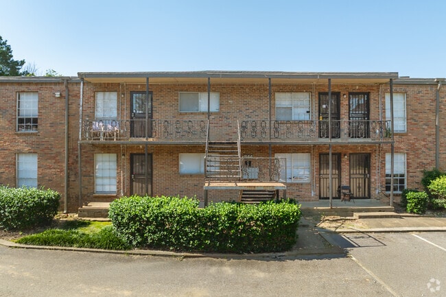
Property Detail
776 Bartlett Rd
06-3071-0-0021
SHELBY
Apartment
Tennessee
RU-3
4
B and X Area of moderate flood hazard, usually the area between the limits of the 100-year and 500-year floods.
5.34 AC
2025
Berclair
2025
Memphis
009800
Memphis, TN-MS-AR
127,738 SF
NEARBY LISTINGS FOR SALE OR LEASE
DEMOGRAPHICS near 776 Bartlett Rd
1 mile
3 mile
5 mile
2025 Total Population
7,387
69,242
200,080
2030 Population
7,173
67,487
196,219
Pop Growth 2025-2030
(2.90%)
(2.53%)
(1.93%)
Average Age
37
37
38
2025 Total Households
2,972
26,963
80,952
HH Growth 2025-2030
(2.99%)
(2.73%)
(2.07%)
Median Household Inc
$75,328
$68,254
$63,204
Avg Household Size
2.40
2.50
2.40
2025 Avg HH Vehicles
2.00
2.00
2.00
Median Home Value
$260,987
$290,632
$256,812
Median Year Built
1956
1960
1968
Nearby Places
Map Layers
Map Styles
 Street
 Aerial
Layers
 Traffic
 Biking
Places
Listings with unknown addresses are not visible on the map
- Restaurants
- Banks
- Shops
- Fitness
- Groceries
PUBLIC TRANSPORTATION
AIRPORT
Memphis International
Drive
Walk
Distance
Memphis International
21 min
13.4 mi
Freight Ports
Port of Shreveport
Drive
Walk
Distance
Port of Shreveport
413 min
377.7 mi
Nearby Properties
Address
Land Use
TOTAL SIZE
Lot Size
Zoning
Address
Land Use
TOTAL SIZE
Lot Size
Zoning
253,002 SF
2.82 AC
CA
Address
Land Use
TOTAL SIZE
Lot Size
Zoning
85,062 SF
8.43 AC
CA
Address
Land Use
TOTAL SIZE
Lot Size
Zoning
99,768 SF
100.86 AC
EMP
Address
Land Use
TOTAL SIZE
Lot Size
Zoning
63,114 SF
7.13 AC
CA
Address
Land Use
TOTAL SIZE
Lot Size
Zoning
45.85 AC
CA
Address
Land Use
TOTAL SIZE
Lot Size
Zoning
24.72 AC
R-10
Address
Land Use
TOTAL SIZE
Lot Size
Zoning
192,560 SF
10.16 AC
CA
Address
Land Use
TOTAL SIZE
Lot Size
Zoning
104.22 AC
R-15
Address
Land Use
TOTAL SIZE
Lot Size
Zoning
206,186 SF
13.64 AC
CMU-2
Address
Land Use
TOTAL SIZE
Lot Size
Zoning
116,745 SF
10.46 AC
CA
Address
Land Use
TOTAL SIZE
Lot Size
Zoning
123,976 SF
10.31 AC
CMU-3
Address
Land Use
TOTAL SIZE
Lot Size
Zoning
449,267 SF
20.03 AC
RU-3
Address
Land Use
TOTAL SIZE
Lot Size
Zoning
80,836 SF
6.84 AC
RU-3
Address
Land Use
TOTAL SIZE
Lot Size
Zoning
30,201 SF
44.30 AC
RU-2
Address
Land Use
TOTAL SIZE
Lot Size
Zoning
37,490 SF
4.42 AC
CMU-2
Address
Land Use
TOTAL SIZE
Lot Size
Zoning
76,115 SF
4.94 AC
CMU-3
Address
Land Use
TOTAL SIZE
Lot Size
Zoning
100,182 SF
9.39 AC
CMU-3
Address
Land Use
TOTAL SIZE
Lot Size
Zoning
31.54 AC
CA
Address
Land Use
TOTAL SIZE
Lot Size
Zoning
62,400 SF
38.29 AC
RU-3
Address
Land Use
TOTAL SIZE
Lot Size
Zoning
82,123 SF
9.89 AC
R-15
Address
Land Use
TOTAL SIZE
Lot Size
Zoning
274,100 SF
7.79 AC
CMU-3
Address
Land Use
TOTAL SIZE
Lot Size
Zoning
50,818 SF
13.30 AC
RU-3
Address
Land Use
TOTAL SIZE
Lot Size
Zoning
217,564 SF
20.41 AC
AG
Address
Land Use
TOTAL SIZE
Lot Size
Zoning
19.54 AC
R-10
Address
Land Use
TOTAL SIZE
Lot Size
Zoning
39,914 SF
0.57 AC
CA
Address
Land Use
TOTAL SIZE
Lot Size
Zoning
64,294 SF
4.90 AC
CMU-3
Address
Land Use
TOTAL SIZE
Lot Size
Zoning
72,972 SF
0.65 AC
CA
Address
Land Use
TOTAL SIZE
Lot Size
Zoning
78,948 SF
33.77 AC
RU-3
Address
Land Use
TOTAL SIZE
Lot Size
Zoning
36,148 SF
5.84 AC
R-15
Address
Land Use
TOTAL SIZE
Lot Size
Zoning
151,958 SF
12.78 AC
CMU-3
The World's #1 Commercial Real Estate Marketplace
Connect with us
© 2026 CoStar Group
The information above has been obtained from sources believed reliable. While we do not doubt its accuracy we have not verified it and make no guarantee, warranty or representation about it. It is your responsibility to independently confirm its accuracy and completeness. Any projections, opinions, assumptions, or estimates used are for example only and do not represent the current or future performance of the property. The value of this transaction to you depends on tax and other factors which should be evaluated by your tax, financial, and legal advisors. You and your advisors should conduct a careful, independent investigation of the property to determine to your satisfaction the suitability of the property for your needs.