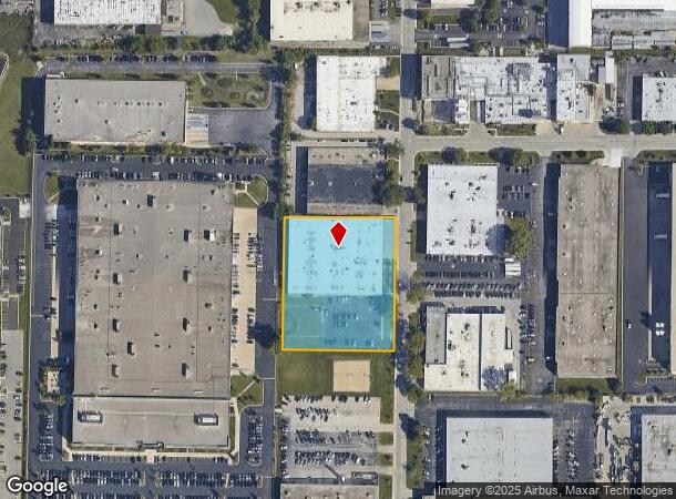
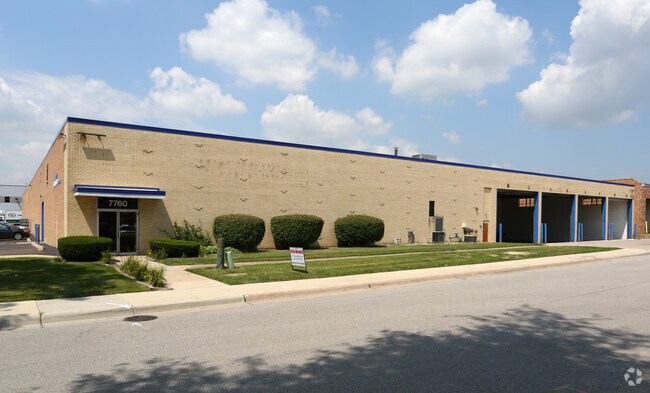
Property Record
7760 N Merrimac Ave, Niles, IL 60714


NEARBY LISTINGS FOR SALE OR LEASE
Property Detail
7760 N Merrimac Ave
10-29-102-006-0000
Niles
Industrialgeneral
Cook
X
Illinois
17031C0243J
2.34 AC
2023
North Cook
2024
Chicago
808200
Chicago-Naperville-Elgin, IL-IN-WI
49,894 SF
DEMOGRAPHICS near 7760 N Merrimac Ave
1 Mile
3 Mile
5 Mile
2024 Total Population
8,341
169,975
531,976
2029 Population
8,067
164,665
513,751
Pop Growth 2024-2029
(3.28%)
(3.12%)
(3.43%)
Average Age
44
43
42
2024 Total Households
3,062
63,003
194,897
HH Growth 2024-2029
(3.63%)
(3.48%)
(3.77%)
Median Household Inc
$82,803
$91,768
$87,411
Avg Household Size
2.60
2.60
2.60
2024 Avg HH Vehicles
2.00
2.00
2.00
Median Home Value
$352,503
$375,835
$375,445
Median Year Built
1958
1956
1957
Nearby Places
Map Layers
Map Styles
 Street
 Aerial
- Restaurants
- Banks
- Shops
- Fitness
- Groceries
PUBLIC TRANSPORTATION
COMMUTER RAIL
Morton Grove Station (Milwaukee District North Line - Northeast Illinois Regional Commuter Railroad (Metra))
DRIVE
WALK
Distance
Morton Grove Station (Milwaukee District North Line - Northeast Illinois Regional Commuter Railroad (Metra))
4 min
1.2 mi
Edgebrook Station (Milwaukee District North Line - Northeast Illinois Regional Commuter Railroad (Metra))
DRIVE
WALK
Distance
Edgebrook Station (Milwaukee District North Line - Northeast Illinois Regional Commuter Railroad (Metra))
6 min
3.0 mi
AIRPORT
Chicago O'Hare International
DRIVE
WALK
Distance
Chicago O'Hare International
17 min
9.1 mi
Chicago Midway International
DRIVE
WALK
Distance
Chicago Midway International
34 min
19.5 mi
Nearby Properties
Address
Land Use
TOTAL SIZE
Lot Size
Zoning
Address
Land Use
TOTAL SIZE
Lot Size
Zoning
999,808 SF
50.13 AC
Address
Land Use
TOTAL SIZE
Lot Size
Zoning
203,090 SF
7.96 AC
Address
Land Use
TOTAL SIZE
Lot Size
Zoning
24.49 AC
Address
Land Use
TOTAL SIZE
Lot Size
Zoning
39.26 AC
Address
Land Use
TOTAL SIZE
Lot Size
Zoning
10.24 AC
Address
Land Use
TOTAL SIZE
Lot Size
Zoning
414,878 SF
20.79 AC
Address
Land Use
TOTAL SIZE
Lot Size
Zoning
Address
Land Use
TOTAL SIZE
Lot Size
Zoning
315,373 SF
26.19 AC
Address
Land Use
TOTAL SIZE
Lot Size
Zoning
9.38 AC
PD 1179,PO
Address
Land Use
TOTAL SIZE
Lot Size
Zoning
269,500 SF
11.03 AC
Address
Land Use
TOTAL SIZE
Lot Size
Zoning
372,244 SF
7.12 AC
Address
Land Use
TOTAL SIZE
Lot Size
Zoning
103,323 SF
10.65 AC
Address
Land Use
TOTAL SIZE
Lot Size
Zoning
172,500 SF
2.42 AC
Address
Land Use
TOTAL SIZE
Lot Size
Zoning
16.27 AC
Address
Land Use
TOTAL SIZE
Lot Size
Zoning
43,765 SF
2.79 AC
Address
Land Use
TOTAL SIZE
Lot Size
Zoning
232,552 SF
5.78 AC
Address
Land Use
TOTAL SIZE
Lot Size
Zoning
219,116 SF
4.97 AC
Address
Land Use
TOTAL SIZE
Lot Size
Zoning
486,884 SF
16.41 AC
Address
Land Use
TOTAL SIZE
Lot Size
Zoning
450,768 SF
6.97 AC
Address
Land Use
TOTAL SIZE
Lot Size
Zoning
429,949 SF
16.06 AC
Address
Land Use
TOTAL SIZE
Lot Size
Zoning
552,152 SF
7.88 AC
Address
Land Use
TOTAL SIZE
Lot Size
Zoning
231,865 SF
3.16 AC
Address
Land Use
TOTAL SIZE
Lot Size
Zoning
5.60 AC
Address
Land Use
TOTAL SIZE
Lot Size
Zoning
320,535 SF
12.44 AC
Address
Land Use
TOTAL SIZE
Lot Size
Zoning
166,728 SF
11.79 AC
Address
Land Use
TOTAL SIZE
Lot Size
Zoning
195,849 SF
6.55 AC
Address
Land Use
TOTAL SIZE
Lot Size
Zoning
92,457 SF
4.09 AC
Address
Land Use
TOTAL SIZE
Lot Size
Zoning
629,244 SF
11.07 AC
RS-2
Address
Land Use
TOTAL SIZE
Lot Size
Zoning
424,257 SF
Address
Land Use
TOTAL SIZE
Lot Size
Zoning
122,489 SF
9.92 AC
The World's #1 Commercial Real Estate Marketplace
Connect with us
© 2025 CoStar Group
The information above has been obtained from sources believed reliable. While we do not doubt its accuracy we have not verified it and make no guarantee, warranty or representation about it. It is your responsibility to independently confirm its accuracy and completeness. Any projections, opinions, assumptions, or estimates used are for example only and do not represent the current or future performance of the property. The value of this transaction to you depends on tax and other factors which should be evaluated by your tax, financial, and legal advisors. You and your advisors should conduct a careful, independent investigation of the property to determine to your satisfaction the suitability of the property for your needs.