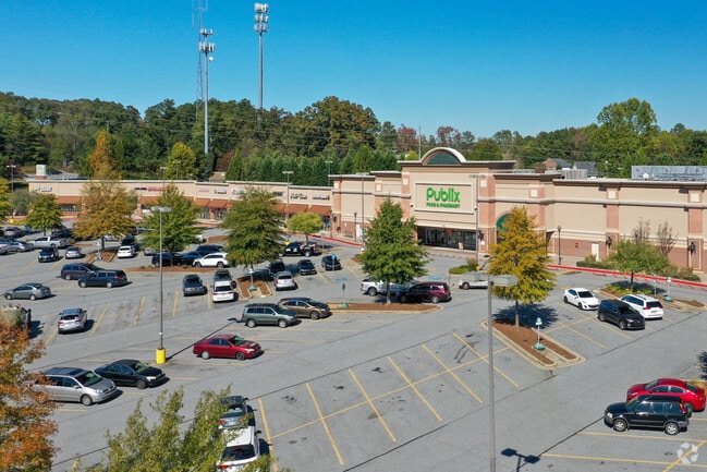
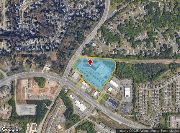
Property Record
7764 Mcginnis Ferry Rd, Suwanee, GA 30024
NEARBY LISTINGS FOR SALE OR LEASE
Property Detail
7764 Mcginnis Ferry Rd
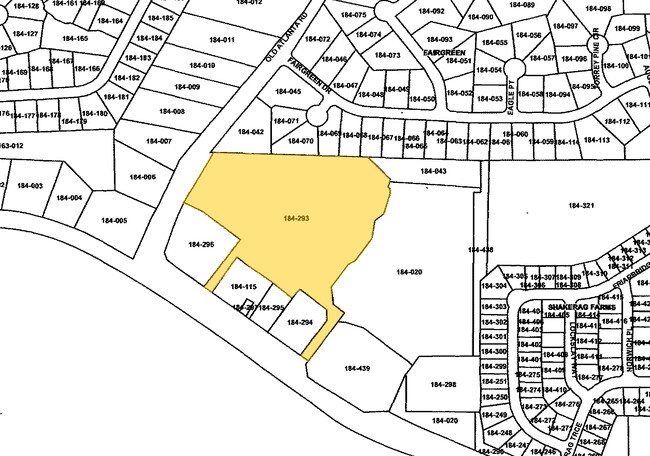
184-293
1-1 484 SHOPPING CNT TRCT
Commercialnec
Forsyth
X
Georgia
13121C0092G
11.59 AC
2024
Cumming/Forsyth Cnty
2025
Atlanta
130608
Atlanta-Sandy Springs-Roswell, GA
67,006 SF
DEMOGRAPHICS near 7764 Mcginnis Ferry Rd
1 Mile
3 Mile
5 Mile
2024 Total Population
7,043
60,109
182,434
2029 Population
7,697
64,524
194,285
Pop Growth 2024-2029
+ 9.29%
+ 7.34%
+ 6.50%
Average Age
38
39
39
2024 Total Households
2,090
20,096
60,881
HH Growth 2024-2029
+ 9.43%
+ 7.29%
+ 6.39%
Median Household Inc
$140,136
$134,969
$126,595
Avg Household Size
3.20
3.00
3.00
2024 Avg HH Vehicles
2.00
2.00
2.00
Median Home Value
$574,507
$469,257
$450,311
Median Year Built
2002
1999
1997
Nearby Places
- Restaurants
- Banks
- Shops
- Fitness
- Groceries
SALE & LEASE HISTORY
LISTING DATE
SALE/LEASE

Oct 30, 2017
For Lease
Oct 12, 2016
For Lease
Feb 23, 2018
For Lease
Dec 15, 2022
For Lease
Nearby Properties
Address
Land Use
TOTAL SIZE
Lot Size
Zoning
Address
Land Use
TOTAL SIZE
Lot Size
Zoning
509,302 SF
55.13 AC
RM8
Address
Land Use
TOTAL SIZE
Lot Size
Zoning
534,578 SF
44.21 AC
RM8
Address
Land Use
TOTAL SIZE
Lot Size
Zoning
393,939 SF
42.21 AC
RM8
Address
Land Use
TOTAL SIZE
Lot Size
Zoning
321,541 SF
63.16 AC
OI
Address
Land Use
TOTAL SIZE
Lot Size
Zoning
359,241 SF
21.02 AC
PMUD
Address
Land Use
TOTAL SIZE
Lot Size
Zoning
559,910 SF
74.65 AC
Address
Land Use
TOTAL SIZE
Lot Size
Zoning
334,841 SF
28.14 AC
RM13
Address
Land Use
TOTAL SIZE
Lot Size
Zoning
299,952 SF
23.49 AC
MIAC
Address
Land Use
TOTAL SIZE
Lot Size
Zoning
372,904 SF
11.64 AC
PUD
Address
Land Use
TOTAL SIZE
Lot Size
Zoning
253,169 SF
8.74 AC
RM24
Address
Land Use
TOTAL SIZE
Lot Size
Zoning
234,420 SF
10.35 AC
PMUD
Address
Land Use
TOTAL SIZE
Lot Size
Zoning
370,414 SF
14.34 AC
PMUD
Address
Land Use
TOTAL SIZE
Lot Size
Zoning
321,116 SF
17.06 AC
CBD
Address
Land Use
TOTAL SIZE
Lot Size
Zoning
244,177 SF
8.96 AC
MIXU
Address
Land Use
TOTAL SIZE
Lot Size
Zoning
214,626 SF
6.29 AC
Address
Land Use
TOTAL SIZE
Lot Size
Zoning
289,676 SF
4.03 AC
C1
Address
Land Use
TOTAL SIZE
Lot Size
Zoning
185,524 SF
12.61 AC
M1
Address
Land Use
TOTAL SIZE
Lot Size
Zoning
343,180 SF
17.29 AC
OI
Address
Land Use
TOTAL SIZE
Lot Size
Zoning
163,592 SF
17.60 AC
OI
Address
Land Use
TOTAL SIZE
Lot Size
Zoning
1,682 SF
303.40 AC
A1
Address
Land Use
TOTAL SIZE
Lot Size
Zoning
133,800 SF
5.20 AC
C1
Address
Land Use
TOTAL SIZE
Lot Size
Zoning
21.36 AC
MIXU
Address
Land Use
TOTAL SIZE
Lot Size
Zoning
14,880 SF
16.51 AC
CBD
Address
Land Use
TOTAL SIZE
Lot Size
Zoning
102,784 SF
9.16 AC
MIAC
Address
Land Use
TOTAL SIZE
Lot Size
Zoning
196,380 SF
15.97 AC
M1
Address
Land Use
TOTAL SIZE
Lot Size
Zoning
45,603 SF
8.36 AC
CBD
Address
Land Use
TOTAL SIZE
Lot Size
Zoning
117,036 SF
13.62 AC
CBD
Address
Land Use
TOTAL SIZE
Lot Size
Zoning
109,568 SF
2.85 AC
C2
Address
Land Use
TOTAL SIZE
Lot Size
Zoning
43,427 SF
31.12 AC
M1
Address
Land Use
TOTAL SIZE
Lot Size
Zoning
150,402 SF
14.12 AC
OI
The World's #1 Commercial Real Estate Marketplace
Connect with us
© 2025 CoStar Group
The information above has been obtained from sources believed reliable. While we do not doubt its accuracy we have not verified it and make no guarantee, warranty or representation about it. It is your responsibility to independently confirm its accuracy and completeness. Any projections, opinions, assumptions, or estimates used are for example only and do not represent the current or future performance of the property. The value of this transaction to you depends on tax and other factors which should be evaluated by your tax, financial, and legal advisors. You and your advisors should conduct a careful, independent investigation of the property to determine to your satisfaction the suitability of the property for your needs.