Property Record
7767 Lila Dr, Roanoke, VA 24019
NEARBY LISTINGS FOR SALE OR LEASE
-
-
View all Roanoke listings for sale on LoopNet.com
Property Detail
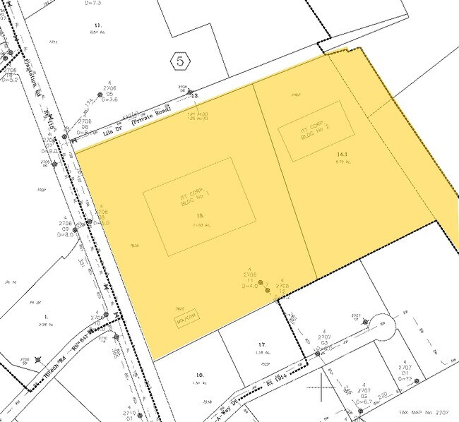
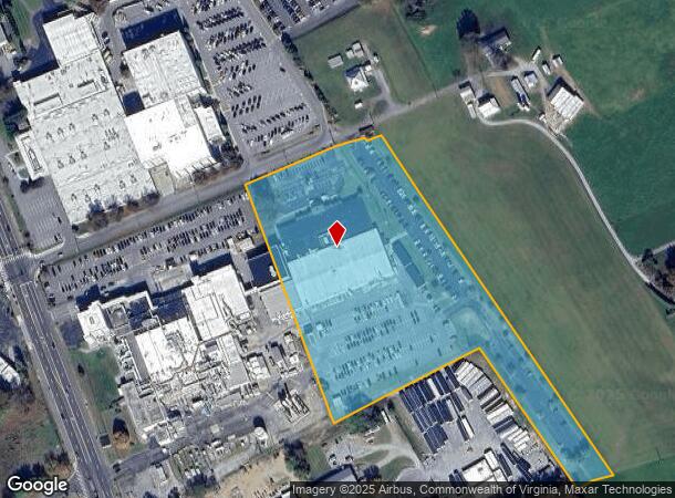
7767 Lila Dr
Roanoke, VA
Plantation Rd Commercial
027.06-05-14.01-0000
LT A RESUBD FOR ITT INDUSTRISINC HOLLINS
Manufacturinglight
Roanoke
X
Virginia
51023C0455C
a
2025
8.79 AC
2025
Northeast Roanoke
030206
Roanoke
68,730 SF
DEMOGRAPHICS near 7767 Lila Dr
1 Mile
3 Mile
5 Mile
2024 Total Population
2,910
26,210
73,505
2029 Population
2,920
26,194
73,129
Pop Growth 2024-2029
+ 0.34%
(0.06%)
(0.51%)
Average Age
41
43
41
2024 Total Households
1,056
10,798
30,376
HH Growth 2024-2029
+ 0.47%
(0.09%)
(0.53%)
Median Household Inc
$81,724
$64,013
$56,432
Avg Household Size
2.30
2.30
2.30
2024 Avg HH Vehicles
2.00
2.00
2.00
Median Home Value
$259,999
$193,967
$183,358
Median Year Built
1983
1973
1972
Nearby Places
Map Layers
Map Styles
 Street
 Aerial
- Restaurants
- Banks
- Shops
- Fitness
- Groceries
PUBLIC TRANSPORTATION
COMMUTER RAIL
DRIVE
WALK
Distance
13 min
7.0 mi
AIRPORT
Roanoke/Blacksburg Regional (Woodrum Field)
DRIVE
WALK
Distance
Roanoke/Blacksburg Regional (Woodrum Field)
10 min
4.0 mi
Nearby Properties
Address
Land Use
TOTAL SIZE
Lot Size
Zoning
Address
Land Use
TOTAL SIZE
Lot Size
Zoning
8,930 SF
604.76 AC
AD
Address
Land Use
TOTAL SIZE
Lot Size
Zoning
5,957.14 AC
FC
Address
Land Use
TOTAL SIZE
Lot Size
Zoning
67,903 SF
11.96 AC
I2
Address
Land Use
TOTAL SIZE
Lot Size
Zoning
609,211 SF
41.01 AC
I1C
Address
Land Use
TOTAL SIZE
Lot Size
Zoning
40.04 AC
M-2
Address
Land Use
TOTAL SIZE
Lot Size
Zoning
15,312 SF
182.27 AC
AG3
Address
Land Use
TOTAL SIZE
Lot Size
Zoning
10,878 SF
10.34 AC
RMF
Address
Land Use
TOTAL SIZE
Lot Size
Zoning
207,812 SF
22.62 AC
CLS
Address
Land Use
TOTAL SIZE
Lot Size
Zoning
22.52 AC
R-1
Address
Land Use
TOTAL SIZE
Lot Size
Zoning
124,725 SF
6.53 AC
I1
Address
Land Use
TOTAL SIZE
Lot Size
Zoning
48,935 SF
9.15 AC
RMF
Address
Land Use
TOTAL SIZE
Lot Size
Zoning
139,654 SF
4.77 AC
C2S
Address
Land Use
TOTAL SIZE
Lot Size
Zoning
36.98 AC
M-1
Address
Land Use
TOTAL SIZE
Lot Size
Zoning
22,950 SF
9.50 AC
R3
Address
Land Use
TOTAL SIZE
Lot Size
Zoning
198,089 SF
46.65 AC
AD
Address
Land Use
TOTAL SIZE
Lot Size
Zoning
130,957 SF
15.12 AC
CLS
Address
Land Use
TOTAL SIZE
Lot Size
Zoning
135,212 SF
11.29 AC
CLS
Address
Land Use
TOTAL SIZE
Lot Size
Zoning
112,165 SF
9.27 AC
CLS
Address
Land Use
TOTAL SIZE
Lot Size
Zoning
70,091 SF
11.82 AC
R1
Address
Land Use
TOTAL SIZE
Lot Size
Zoning
35,582 SF
16.36 AC
I2S
Address
Land Use
TOTAL SIZE
Lot Size
Zoning
5,433 SF
20.63 AC
AD
Address
Land Use
TOTAL SIZE
Lot Size
Zoning
70,770 SF
6 AC
R3
Address
Land Use
TOTAL SIZE
Lot Size
Zoning
88,570 SF
10.02 AC
CLS
Address
Land Use
TOTAL SIZE
Lot Size
Zoning
24,512 SF
9.10 AC
C2S
Address
Land Use
TOTAL SIZE
Lot Size
Zoning
92,239 SF
11.41 AC
CLS
Address
Land Use
TOTAL SIZE
Lot Size
Zoning
35,796 SF
3.57 AC
C2CS
Address
Land Use
TOTAL SIZE
Lot Size
Zoning
9.98 AC
A1
Address
Land Use
TOTAL SIZE
Lot Size
Zoning
22,950 SF
3.54 AC
Address
Land Use
TOTAL SIZE
Lot Size
Zoning
20,086 SF
9.79 AC
R1S
Address
Land Use
TOTAL SIZE
Lot Size
Zoning
147,992 SF
11.28 AC
I1C
The World's #1 Commercial Real Estate Marketplace
Connect with us
© 2026 CoStar Group
The information above has been obtained from sources believed reliable. While we do not doubt its accuracy we have not verified it and make no guarantee, warranty or representation about it. It is your responsibility to independently confirm its accuracy and completeness. Any projections, opinions, assumptions, or estimates used are for example only and do not represent the current or future performance of the property. The value of this transaction to you depends on tax and other factors which should be evaluated by your tax, financial, and legal advisors. You and your advisors should conduct a careful, independent investigation of the property to determine to your satisfaction the suitability of the property for your needs.