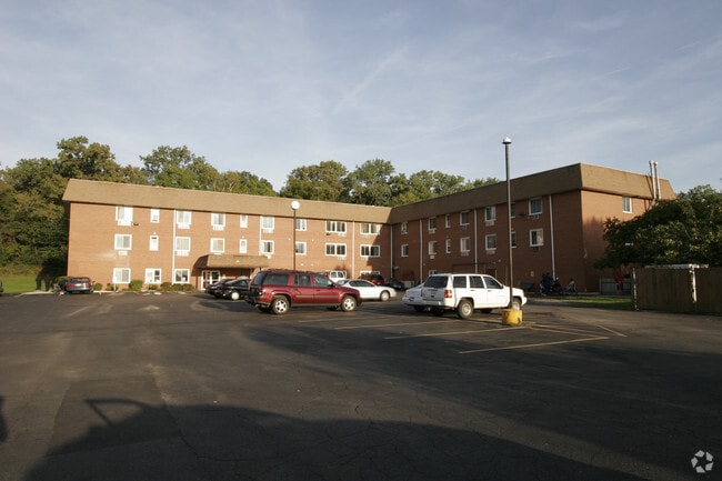
Property Record
777 Draper Ave, Joliet, IL 60432


NEARBY LISTINGS FOR SALE OR LEASE
Property Detail
777 Draper Ave
30-07-11-101-003
THAT PRT OF THE NW1/4 OF SEC.11, T35N-R10E, LYG S OF STEIN AVE, E'LY OF DRAPER AVE, N'LY OF MAPLE RD AND BEING MORE PARTICULA
Commercialnec
Will
X
Illinois
17197C0170G
3.62 AC
2024
Joliet/Central Will
2024
Chicago
882200
Chicago-Naperville-Elgin, IL-IN-WI
DEMOGRAPHICS near 777 Draper Ave
1 Mile
3 Mile
5 Mile
2024 Total Population
12,775
79,540
148,612
2029 Population
12,809
79,502
148,407
Pop Growth 2024-2029
+ 0.27%
(0.05%)
(0.14%)
Average Age
35
37
38
2024 Total Households
3,774
26,278
53,188
HH Growth 2024-2029
+ 0.29%
(0.06%)
(0.17%)
Median Household Inc
$49,755
$58,648
$64,712
Avg Household Size
3.20
2.80
2.60
2024 Avg HH Vehicles
2.00
2.00
2.00
Median Home Value
$118,778
$170,242
$197,941
Median Year Built
1953
1956
1965
Nearby Places
Map Layers
Map Styles
 Street
 Aerial
- Restaurants
- Banks
- Shops
- Fitness
- Groceries
PUBLIC TRANSPORTATION
COMMUTER RAIL
Joliet Station (Heritage Corridor Line - Northeast Illinois Regional Commuter Railroad (Metra), Rock Island District Line - Northeast Illinois Regional Commuter Railroad (Metra))
DRIVE
WALK
Distance
Joliet Station (Heritage Corridor Line - Northeast Illinois Regional Commuter Railroad (Metra), Rock Island District Line - Northeast Illinois Regional Commuter Railroad (Metra))
6 min
2.2 mi
Lockport Station (Heritage Corridor Line - Northeast Illinois Regional Commuter Railroad (Metra))
DRIVE
WALK
Distance
Lockport Station (Heritage Corridor Line - Northeast Illinois Regional Commuter Railroad (Metra))
11 min
4.2 mi
AIRPORT
Chicago Midway International
DRIVE
WALK
Distance
Chicago Midway International
44 min
32.9 mi
Freight Ports
Port Milwaukee
DRIVE
WALK
Distance
Port Milwaukee
142 min
116.0 mi
Nearby Properties
Address
Land Use
TOTAL SIZE
Lot Size
Zoning
Address
Land Use
TOTAL SIZE
Lot Size
Zoning
27.63 AC
Address
Land Use
TOTAL SIZE
Lot Size
Zoning
2.19 AC
Address
Land Use
TOTAL SIZE
Lot Size
Zoning
53.05 AC
Address
Land Use
TOTAL SIZE
Lot Size
Zoning
128.88 AC
Address
Land Use
TOTAL SIZE
Lot Size
Zoning
26.04 AC
Address
Land Use
TOTAL SIZE
Lot Size
Zoning
Address
Land Use
TOTAL SIZE
Lot Size
Zoning
30.99 AC
Address
Land Use
TOTAL SIZE
Lot Size
Zoning
22.77 AC
Address
Land Use
TOTAL SIZE
Lot Size
Zoning
3.40 AC
Address
Land Use
TOTAL SIZE
Lot Size
Zoning
Address
Land Use
TOTAL SIZE
Lot Size
Zoning
1.71 AC
Address
Land Use
TOTAL SIZE
Lot Size
Zoning
2.69 AC
Address
Land Use
TOTAL SIZE
Lot Size
Zoning
12 AC
Address
Land Use
TOTAL SIZE
Lot Size
Zoning
2.06 AC
Address
Land Use
TOTAL SIZE
Lot Size
Zoning
7.69 AC
Address
Land Use
TOTAL SIZE
Lot Size
Zoning
0.78 AC
Address
Land Use
TOTAL SIZE
Lot Size
Zoning
1.51 AC
Address
Land Use
TOTAL SIZE
Lot Size
Zoning
33.34 AC
Address
Land Use
TOTAL SIZE
Lot Size
Zoning
8.21 AC
Address
Land Use
TOTAL SIZE
Lot Size
Zoning
0.17 AC
Address
Land Use
TOTAL SIZE
Lot Size
Zoning
7.98 AC
Address
Land Use
TOTAL SIZE
Lot Size
Zoning
18.04 AC
Address
Land Use
TOTAL SIZE
Lot Size
Zoning
10.39 AC
Address
Land Use
TOTAL SIZE
Lot Size
Zoning
Address
Land Use
TOTAL SIZE
Lot Size
Zoning
18.11 AC
Address
Land Use
TOTAL SIZE
Lot Size
Zoning
2.58 AC
Address
Land Use
TOTAL SIZE
Lot Size
Zoning
11.94 AC
Address
Land Use
TOTAL SIZE
Lot Size
Zoning
62.43 AC
Address
Land Use
TOTAL SIZE
Lot Size
Zoning
8.67 AC
The World's #1 Commercial Real Estate Marketplace
Connect with us
© 2026 CoStar Group
The information above has been obtained from sources believed reliable. While we do not doubt its accuracy we have not verified it and make no guarantee, warranty or representation about it. It is your responsibility to independently confirm its accuracy and completeness. Any projections, opinions, assumptions, or estimates used are for example only and do not represent the current or future performance of the property. The value of this transaction to you depends on tax and other factors which should be evaluated by your tax, financial, and legal advisors. You and your advisors should conduct a careful, independent investigation of the property to determine to your satisfaction the suitability of the property for your needs.