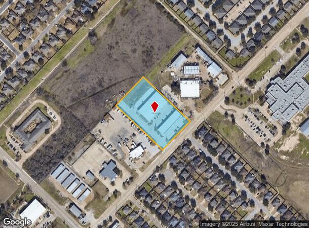
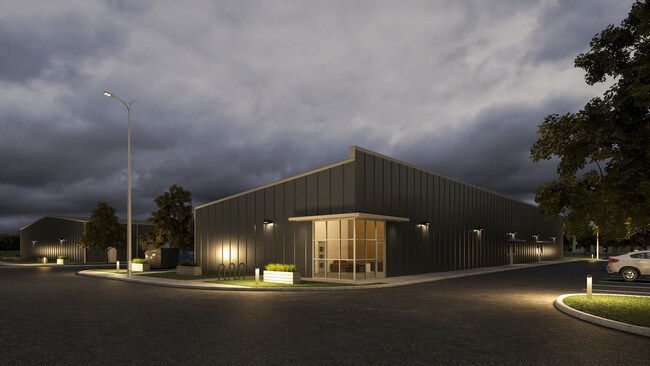
Property Record
777 Graham Rd, College Station, TX 77845

NEARBY LISTINGS FOR SALE OR LEASE
Property Detail
777 Graham Rd
College Station-Bryan, TX
Graham Road Industrial Park Ph 2
30004702010011
GRAHAM ROAD INDUSTRIAL PARK PH 2, BLOCK 1, LOT 1R-1
Commercialnec
Brazos
X
Texas
48041C0310F
1r-1
2024
2.58 AC
2025
Bryan & College Station
002006
Other Market Areas
27,000 SF
DEMOGRAPHICS near 777 Graham Rd
1 Mile
3 Mile
5 Mile
2024 Total Population
10,900
66,339
130,486
2029 Population
11,763
71,771
140,869
Pop Growth 2024-2029
+ 7.92%
+ 8.19%
+ 7.96%
Average Age
34
33
30
2024 Total Households
3,961
25,539
45,843
HH Growth 2024-2029
+ 8.31%
+ 8.61%
+ 8.82%
Median Household Inc
$68,371
$55,098
$47,026
Avg Household Size
2.70
2.60
2.40
2024 Avg HH Vehicles
2.00
2.00
2.00
Median Home Value
$258,189
$295,729
$319,163
Median Year Built
2000
1999
1998
Nearby Places
Map Layers
Map Styles
 Street
 Aerial
- Restaurants
- Banks
- Shops
- Fitness
- Groceries
PUBLIC TRANSPORTATION
AIRPORT
Easterwood Field
DRIVE
WALK
Distance
Easterwood Field
17 min
7.0 mi
Freight Ports
Port of Houston
DRIVE
WALK
Distance
Port of Houston
117 min
94.7 mi
Nearby Properties
Address
Land Use
TOTAL SIZE
Lot Size
Zoning
Address
Land Use
TOTAL SIZE
Lot Size
Zoning
397,850 SF
54.54 AC
Address
Land Use
TOTAL SIZE
Lot Size
Zoning
Address
Land Use
TOTAL SIZE
Lot Size
Zoning
527,220 SF
41.58 AC
Address
Land Use
TOTAL SIZE
Lot Size
Zoning
369,909 SF
29.84 AC
Address
Land Use
TOTAL SIZE
Lot Size
Zoning
353,843 SF
36.83 AC
Address
Land Use
TOTAL SIZE
Lot Size
Zoning
409,205 SF
26.99 AC
Address
Land Use
TOTAL SIZE
Lot Size
Zoning
382,342 SF
40 AC
Address
Land Use
TOTAL SIZE
Lot Size
Zoning
353,988 SF
17.66 AC
Address
Land Use
TOTAL SIZE
Lot Size
Zoning
359,171 SF
16.98 AC
Address
Land Use
TOTAL SIZE
Lot Size
Zoning
284,699 SF
15.21 AC
Address
Land Use
TOTAL SIZE
Lot Size
Zoning
312,391 SF
8.99 AC
Address
Land Use
TOTAL SIZE
Lot Size
Zoning
267,852 SF
17.91 AC
Address
Land Use
TOTAL SIZE
Lot Size
Zoning
232,343 SF
23.33 AC
Address
Land Use
TOTAL SIZE
Lot Size
Zoning
222,990 SF
16.24 AC
Address
Land Use
TOTAL SIZE
Lot Size
Zoning
249,346 SF
12 AC
Address
Land Use
TOTAL SIZE
Lot Size
Zoning
218,263 SF
8.92 AC
Address
Land Use
TOTAL SIZE
Lot Size
Zoning
242,681 SF
22.18 AC
Address
Land Use
TOTAL SIZE
Lot Size
Zoning
283,935 SF
11.06 AC
Address
Land Use
TOTAL SIZE
Lot Size
Zoning
235,145 SF
3.12 AC
Address
Land Use
TOTAL SIZE
Lot Size
Zoning
127,791 SF
1 AC
Address
Land Use
TOTAL SIZE
Lot Size
Zoning
205,490 SF
7.10 AC
Address
Land Use
TOTAL SIZE
Lot Size
Zoning
213,331 SF
12.06 AC
Address
Land Use
TOTAL SIZE
Lot Size
Zoning
250,223 SF
11.19 AC
Address
Land Use
TOTAL SIZE
Lot Size
Zoning
51,424 SF
16.87 AC
Address
Land Use
TOTAL SIZE
Lot Size
Zoning
152,440 SF
13.49 AC
Address
Land Use
TOTAL SIZE
Lot Size
Zoning
187,212 SF
11.15 AC
Address
Land Use
TOTAL SIZE
Lot Size
Zoning
73,350 SF
25.28 AC
Address
Land Use
TOTAL SIZE
Lot Size
Zoning
Address
Land Use
TOTAL SIZE
Lot Size
Zoning
109,824 SF
6.76 AC
Address
Land Use
TOTAL SIZE
Lot Size
Zoning
99,360 SF
8.79 AC
The World's #1 Commercial Real Estate Marketplace
Connect with us
© 2026 CoStar Group
The information above has been obtained from sources believed reliable. While we do not doubt its accuracy we have not verified it and make no guarantee, warranty or representation about it. It is your responsibility to independently confirm its accuracy and completeness. Any projections, opinions, assumptions, or estimates used are for example only and do not represent the current or future performance of the property. The value of this transaction to you depends on tax and other factors which should be evaluated by your tax, financial, and legal advisors. You and your advisors should conduct a careful, independent investigation of the property to determine to your satisfaction the suitability of the property for your needs.