Property Record
777 Main Rd, Tiverton, RI 02878

Property Detail
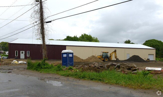
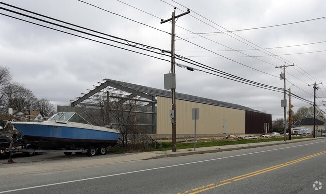
777 Main Rd
Commercialbuilding
NEWPORT
GC
Rhode Island
B and X Area of moderate flood hazard, usually the area between the limits of the 100-year and 500-year floods.
1.05 AC
2025
Newport County
2025
Providence
041602
Providence-Warwick, RI-MA
8,000 SF
TIVE-000117-000000-000224
NEARBY LISTINGS FOR SALE OR LEASE
-
-
View all Tiverton listings for sale on LoopNet.com
DEMOGRAPHICS near 777 Main Rd
1 mile
3 mile
5 mile
2025 Total Population
3,816
33,851
122,281
2030 Population
3,624
33,444
122,456
Pop Growth 2025-2030
(5.03%)
(1.20%)
+ 0.14%
Average Age
51
43
42
2025 Total Households
1,673
14,410
52,187
HH Growth 2025-2030
(4.24%)
(0.92%)
+ 0.37%
Median Household Inc
$100,658
$71,001
$64,904
Avg Household Size
2.20
2.30
2.20
2025 Avg HH Vehicles
2.00
2.00
2.00
Median Home Value
$421,052
$423,819
$437,641
Median Year Built
1958
1951
1950
Nearby Places
Map Layers
Map Styles
 Street
 Aerial
Layers
 Traffic
 Biking
Places
Listings with unknown addresses are not visible on the map
- Restaurants
- Banks
- Shops
- Fitness
- Groceries
PUBLIC TRANSPORTATION
AIRPORT
Rhode Island Tf Green International
Drive
Walk
Distance
Rhode Island Tf Green International
44 min
33.0 mi
Nearby Properties
Address
Land Use
TOTAL SIZE
Lot Size
Zoning
Address
Land Use
TOTAL SIZE
Lot Size
Zoning
11.26 AC
IND
Address
Land Use
TOTAL SIZE
Lot Size
Zoning
27.66 AC
I
Address
Land Use
TOTAL SIZE
Lot Size
Zoning
73,957 SF
46.62 AC
CO
Address
Land Use
TOTAL SIZE
Lot Size
Zoning
183,732 SF
5.50 AC
IND
Address
Land Use
TOTAL SIZE
Lot Size
Zoning
132,666 SF
18.97 AC
IND
Address
Land Use
TOTAL SIZE
Lot Size
Zoning
16.08 AC
N/A
Address
Land Use
TOTAL SIZE
Lot Size
Zoning
107,441 SF
2.10 AC
N/A
Address
Land Use
TOTAL SIZE
Lot Size
Zoning
113,643 SF
4.95 AC
R-4
Address
Land Use
TOTAL SIZE
Lot Size
Zoning
559.70 AC
S
Address
Land Use
TOTAL SIZE
Lot Size
Zoning
150,156 SF
8.77 AC
R40
Address
Land Use
TOTAL SIZE
Lot Size
Zoning
9.44 AC
A-2
Address
Land Use
TOTAL SIZE
Lot Size
Zoning
194,181 SF
3.40 AC
Address
Land Use
TOTAL SIZE
Lot Size
Zoning
124,038 SF
74.50 AC
R60
Address
Land Use
TOTAL SIZE
Lot Size
Zoning
178,538 SF
17.27 AC
I
Address
Land Use
TOTAL SIZE
Lot Size
Zoning
22.36 AC
B-N
Address
Land Use
TOTAL SIZE
Lot Size
Zoning
99,066 SF
3.05 AC
IND
Address
Land Use
TOTAL SIZE
Lot Size
Zoning
144,773 SF
10.50 AC
R60
Address
Land Use
TOTAL SIZE
Lot Size
Zoning
8.83 AC
R-8
Address
Land Use
TOTAL SIZE
Lot Size
Zoning
79,708 SF
0.76 AC
IND
Address
Land Use
TOTAL SIZE
Lot Size
Zoning
3.55 AC
N/A
Address
Land Use
TOTAL SIZE
Lot Size
Zoning
9,288 SF
113.04 AC
R60
Address
Land Use
TOTAL SIZE
Lot Size
Zoning
10 AC
HC
Address
Land Use
TOTAL SIZE
Lot Size
Zoning
44.10 AC
R-40
Address
Land Use
TOTAL SIZE
Lot Size
Zoning
84,000 SF
3.31 AC
I
Address
Land Use
TOTAL SIZE
Lot Size
Zoning
210,866 SF
30.75 AC
R-4
Address
Land Use
TOTAL SIZE
Lot Size
Zoning
3.99 AC
B-N
Address
Land Use
TOTAL SIZE
Lot Size
Zoning
168,869 SF
12.23 AC
IND
Address
Land Use
TOTAL SIZE
Lot Size
Zoning
3.74 AC
R-4
Address
Land Use
TOTAL SIZE
Lot Size
Zoning
1.67 AC
N/A
Address
Land Use
TOTAL SIZE
Lot Size
Zoning
35.50 AC
R-40
The World's #1 Commercial Real Estate Marketplace
Connect with us
© 2026 CoStar Group
The information above has been obtained from sources believed reliable. While we do not doubt its accuracy we have not verified it and make no guarantee, warranty or representation about it. It is your responsibility to independently confirm its accuracy and completeness. Any projections, opinions, assumptions, or estimates used are for example only and do not represent the current or future performance of the property. The value of this transaction to you depends on tax and other factors which should be evaluated by your tax, financial, and legal advisors. You and your advisors should conduct a careful, independent investigation of the property to determine to your satisfaction the suitability of the property for your needs.