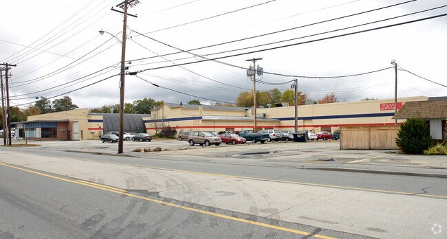
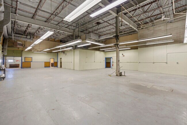
Property Record
777 Main St, Lewiston, ME 04240
NEARBY LISTINGS FOR SALE OR LEASE
-
-
View all Lewiston listings for lease on LoopNet.com
Property Detail
777 Main St
LEWI-000169-000000-000015
Androscoggin
Industrialgeneral
Maine
X
14
23001C0214E
1.42 AC
2025
Maine South & Augusta
2025
Other Market Areas
020900
Lewiston-Auburn, ME
29,997 SF
DEMOGRAPHICS near 777 Main St
1 Mile
3 Mile
5 Mile
2024 Total Population
4,257
41,476
60,928
2029 Population
4,305
42,059
61,660
Pop Growth 2024-2029
+ 1.13%
+ 1.41%
+ 1.20%
Average Age
43
39
41
2024 Total Households
1,609
16,948
25,087
HH Growth 2024-2029
+ 0.87%
+ 1.30%
+ 1.14%
Median Household Inc
$54,481
$46,653
$52,346
Avg Household Size
2.30
2.20
2.20
2024 Avg HH Vehicles
2.00
1.00
2.00
Median Home Value
$217,613
$197,195
$201,582
Median Year Built
1964
1950
1954
Nearby Places
Map Layers
Map Styles
 Street
 Aerial
- Restaurants
- Banks
- Shops
- Fitness
- Groceries
SALE & LEASE HISTORY
LISTING DATE
SALE/LEASE

Sep 22, 2023
For Lease
Sep 22, 2023
For Sale
Jan 19, 2023
For Sale
Aug 07, 2020
For Lease
Aug 07, 2020
For Sale
Apr 29, 2019
For Lease
Apr 20, 2018
For Sale
Nearby Properties
Address
Land Use
TOTAL SIZE
Lot Size
Zoning
Address
Land Use
TOTAL SIZE
Lot Size
Zoning
542,760 SF
8.12 AC
Address
Land Use
TOTAL SIZE
Lot Size
Zoning
1,728 SF
53.55 AC
Address
Land Use
TOTAL SIZE
Lot Size
Zoning
290,822 SF
61.58 AC
Address
Land Use
TOTAL SIZE
Lot Size
Zoning
295,277 SF
124.77 AC
Address
Land Use
TOTAL SIZE
Lot Size
Zoning
Address
Land Use
TOTAL SIZE
Lot Size
Zoning
7.76 AC
Address
Land Use
TOTAL SIZE
Lot Size
Zoning
Address
Land Use
TOTAL SIZE
Lot Size
Zoning
50,000 SF
86.08 AC
Address
Land Use
TOTAL SIZE
Lot Size
Zoning
1.53 AC
Address
Land Use
TOTAL SIZE
Lot Size
Zoning
144,650 SF
16.19 AC
Address
Land Use
TOTAL SIZE
Lot Size
Zoning
67,873 SF
Address
Land Use
TOTAL SIZE
Lot Size
Zoning
290,142 SF
33.80 AC
Address
Land Use
TOTAL SIZE
Lot Size
Zoning
220,227 SF
35.93 AC
Address
Land Use
TOTAL SIZE
Lot Size
Zoning
260,479 SF
23.56 AC
Address
Land Use
TOTAL SIZE
Lot Size
Zoning
106,600 SF
0.73 AC
Address
Land Use
TOTAL SIZE
Lot Size
Zoning
Address
Land Use
TOTAL SIZE
Lot Size
Zoning
93,343 SF
16.41 AC
Address
Land Use
TOTAL SIZE
Lot Size
Zoning
127,660 SF
9.24 AC
Address
Land Use
TOTAL SIZE
Lot Size
Zoning
27,606 SF
1.10 AC
Address
Land Use
TOTAL SIZE
Lot Size
Zoning
77,416 SF
2.88 AC
Address
Land Use
TOTAL SIZE
Lot Size
Zoning
90,085 SF
1.49 AC
Address
Land Use
TOTAL SIZE
Lot Size
Zoning
Address
Land Use
TOTAL SIZE
Lot Size
Zoning
144,665 SF
36.25 AC
Address
Land Use
TOTAL SIZE
Lot Size
Zoning
210,388 SF
1.46 AC
Address
Land Use
TOTAL SIZE
Lot Size
Zoning
134,613 SF
26.87 AC
Address
Land Use
TOTAL SIZE
Lot Size
Zoning
Address
Land Use
TOTAL SIZE
Lot Size
Zoning
125,449 SF
Address
Land Use
TOTAL SIZE
Lot Size
Zoning
94,914 SF
Address
Land Use
TOTAL SIZE
Lot Size
Zoning
76,915 SF
1.83 AC
Address
Land Use
TOTAL SIZE
Lot Size
Zoning
187,994 SF
0.96 AC
The World's #1 Commercial Real Estate Marketplace
Connect with us
© 2025 CoStar Group
The information above has been obtained from sources believed reliable. While we do not doubt its accuracy we have not verified it and make no guarantee, warranty or representation about it. It is your responsibility to independently confirm its accuracy and completeness. Any projections, opinions, assumptions, or estimates used are for example only and do not represent the current or future performance of the property. The value of this transaction to you depends on tax and other factors which should be evaluated by your tax, financial, and legal advisors. You and your advisors should conduct a careful, independent investigation of the property to determine to your satisfaction the suitability of the property for your needs.