Property Record
784 River Rd, Ewing, NJ 08628
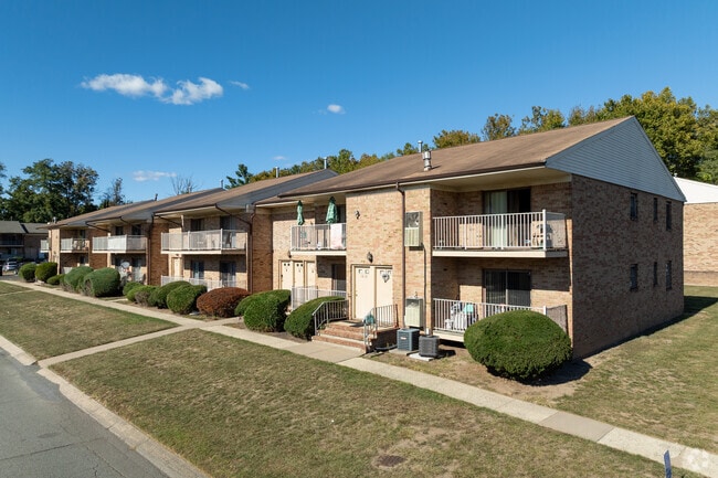


Property Detail
784 River Rd
Trenton-Princeton, NJ
ADDITIONAL LOTS: RIVER EDGE - 308
02-00419-0000-00012
MERCER
Apartment
New Jersey
R-M
12
AE The base floodplain where base flood elevations are provided. AE Zones are now used on new format FIRMs instead of A1-A30 Zones.
27.82 AC
2024
Outer Trenton/Hamilton/Ewing
2025
Northern New Jersey
003708
NEARBY LISTINGS FOR SALE OR LEASE
-
-
View all Ewing listings for sale on LoopNet.com
DEMOGRAPHICS near 784 River Rd
1 mile
3 mile
5 mile
2025 Total Population
4,764
61,941
182,649
2030 Population
4,773
63,502
187,213
Pop Growth 2025-2030
+ 0.19%
+ 2.52%
+ 2.50%
Average Age
45
42
42
2025 Total Households
2,248
23,252
69,621
HH Growth 2025-2030
+ 0.27%
+ 3.20%
+ 2.77%
Median Household Inc
$117,254
$100,866
$91,124
Avg Household Size
2.10
2.40
2.50
2025 Avg HH Vehicles
2.00
2.00
2.00
Median Home Value
$526,853
$460,356
$416,110
Median Year Built
1963
1964
1964
Nearby Places
Map Layers
Map Styles
 Street
 Aerial
Transit
 Traffic
 Biking
Places
Listings with unknown addresses are not visible on the map
- Restaurants
- Banks
- Shops
- Fitness
- Groceries
PUBLIC TRANSPORTATION
COMMUTER RAIL
West Trenton (R3 - Southeastern Pennsylvania Transportation Authority Regional Rail (SEPTA Regional Rail))
Drive
Walk
Distance
West Trenton (R3 - Southeastern Pennsylvania Transportation Authority Regional Rail (SEPTA Regional Rail))
5 min
2.2 mi
Yardley (R3 - Southeastern Pennsylvania Transportation Authority Regional Rail (SEPTA Regional Rail))
Drive
Walk
Distance
Yardley (R3 - Southeastern Pennsylvania Transportation Authority Regional Rail (SEPTA Regional Rail))
9 min
4.5 mi
AIRPORT
Trenton Mercer
Drive
Walk
Distance
Trenton Mercer
8 min
3.5 mi
Freight Ports
Port of Philadelphia
Drive
Walk
Distance
Port of Philadelphia
42 min
29.1 mi
Nearby Properties
Address
Land Use
TOTAL SIZE
Lot Size
Zoning
Address
Land Use
TOTAL SIZE
Lot Size
Zoning
225.40 AC
R-1
Address
Land Use
TOTAL SIZE
Lot Size
Zoning
1,996 SF
125 AC
RA
Address
Land Use
TOTAL SIZE
Lot Size
Zoning
4,320 SF
12.06 AC
PRO
Address
Land Use
TOTAL SIZE
Lot Size
Zoning
96.60 AC
OP-2
Address
Land Use
TOTAL SIZE
Lot Size
Zoning
117.50 AC
OP-1
Address
Land Use
TOTAL SIZE
Lot Size
Zoning
60,000 SF
42.80 AC
IP-1
Address
Land Use
TOTAL SIZE
Lot Size
Zoning
27.21 AC
PRO
Address
Land Use
TOTAL SIZE
Lot Size
Zoning
104.60 AC
IP-1
Address
Land Use
TOTAL SIZE
Lot Size
Zoning
23.50 AC
R-2
Address
Land Use
TOTAL SIZE
Lot Size
Zoning
11.40 AC
Address
Land Use
TOTAL SIZE
Lot Size
Zoning
64.33 AC
R-2
Address
Land Use
TOTAL SIZE
Lot Size
Zoning
12.54 AC
IP-1
Address
Land Use
TOTAL SIZE
Lot Size
Zoning
8.93 AC
Address
Land Use
TOTAL SIZE
Lot Size
Zoning
7,567 SF
34.70 AC
R-1
Address
Land Use
TOTAL SIZE
Lot Size
Zoning
5,254 SF
245.70 AC
R-1
Address
Land Use
TOTAL SIZE
Lot Size
Zoning
11.09 AC
Address
Land Use
TOTAL SIZE
Lot Size
Zoning
26.20 AC
OP-1
Address
Land Use
TOTAL SIZE
Lot Size
Zoning
63.40 AC
R-1
Address
Land Use
TOTAL SIZE
Lot Size
Zoning
1.30 AC
Address
Land Use
TOTAL SIZE
Lot Size
Zoning
8.46 AC
RA
Address
Land Use
TOTAL SIZE
Lot Size
Zoning
35.41 AC
R-M
Address
Land Use
TOTAL SIZE
Lot Size
Zoning
1.81 AC
IP-1
Address
Land Use
TOTAL SIZE
Lot Size
Zoning
17,832 SF
26.01 AC
RM
Address
Land Use
TOTAL SIZE
Lot Size
Zoning
896 SF
20.71 AC
R-2
Address
Land Use
TOTAL SIZE
Lot Size
Zoning
Address
Land Use
TOTAL SIZE
Lot Size
Zoning
34.18 AC
R-2
Address
Land Use
TOTAL SIZE
Lot Size
Zoning
12.12 AC
IP-1
Address
Land Use
TOTAL SIZE
Lot Size
Zoning
3.69 AC
R-2
Address
Land Use
TOTAL SIZE
Lot Size
Zoning
44.90 AC
R-2
The World's #1 Commercial Real Estate Marketplace
Connect with us
© 2026 CoStar Group
The information above has been obtained from sources believed reliable. While we do not doubt its accuracy we have not verified it and make no guarantee, warranty or representation about it. It is your responsibility to independently confirm its accuracy and completeness. Any projections, opinions, assumptions, or estimates used are for example only and do not represent the current or future performance of the property. The value of this transaction to you depends on tax and other factors which should be evaluated by your tax, financial, and legal advisors. You and your advisors should conduct a careful, independent investigation of the property to determine to your satisfaction the suitability of the property for your needs.