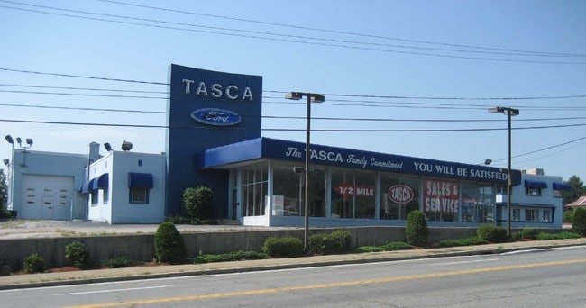
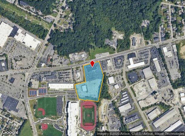
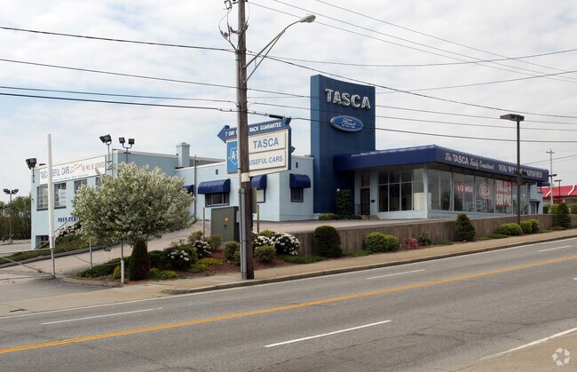
Property Record
777 Taunton Ave, East Providence, RI 02914
NEARBY LISTINGS FOR SALE OR LEASE
Property Detail
777 Taunton Ave
EPRO-000506-000001-000005
Providence
Commercialnec
Rhode Island
X
5
44007C0328J
6.37 AC
2025
East Providence
2025
Providence
010300
Providence-Warwick, RI-MA
20,574 SF
DEMOGRAPHICS near 777 Taunton Ave
1 Mile
3 Mile
5 Mile
2024 Total Population
9,639
79,407
311,120
2029 Population
9,546
79,140
308,243
Pop Growth 2024-2029
(0.96%)
(0.34%)
(0.92%)
Average Age
44
40
39
2024 Total Households
4,169
32,168
124,589
HH Growth 2024-2029
(0.98%)
(0.34%)
(0.88%)
Median Household Inc
$55,786
$75,027
$62,499
Avg Household Size
2.20
2.20
2.30
2024 Avg HH Vehicles
2.00
2.00
1.00
Median Home Value
$285,091
$364,096
$302,312
Median Year Built
1951
1950
1948
Nearby Places
Map Layers
Map Styles
 Street
 Aerial
- Restaurants
- Banks
- Shops
- Fitness
- Groceries
PUBLIC TRANSPORTATION
COMMUTER RAIL
Providence (Providence/Stoughton Line - Massachusetts Bay Transportation Authority Commuter Rail (Purple Line))
DRIVE
WALK
Distance
Providence (Providence/Stoughton Line - Massachusetts Bay Transportation Authority Commuter Rail (Purple Line))
7 min
3.7 mi
Pawtucket/Central Falls (Foxboro Event Service - MBTA, Providence/Stoughton Line - MBTA)
DRIVE
WALK
Distance
Pawtucket/Central Falls (Foxboro Event Service - MBTA, Providence/Stoughton Line - MBTA)
10 min
5.5 mi
AIRPORT
Rhode Island Tf Green International
DRIVE
WALK
Distance
Rhode Island Tf Green International
20 min
10.6 mi
Freight Ports
Port of Davisville, RI
DRIVE
WALK
Distance
Port of Davisville, RI
36 min
23.0 mi
Nearby Properties
Address
Land Use
TOTAL SIZE
Lot Size
Zoning
Address
Land Use
TOTAL SIZE
Lot Size
Zoning
45,407 SF
38.03 AC
I-2
Address
Land Use
TOTAL SIZE
Lot Size
Zoning
19.69 AC
R-1
Address
Land Use
TOTAL SIZE
Lot Size
Zoning
317,728 SF
28.20 AC
O1
Address
Land Use
TOTAL SIZE
Lot Size
Zoning
396,000 SF
0.12 AC
D-1-30
Address
Land Use
TOTAL SIZE
Lot Size
Zoning
79.57 AC
O1
Address
Land Use
TOTAL SIZE
Lot Size
Zoning
205,551 SF
1.38 AC
C-2
Address
Land Use
TOTAL SIZE
Lot Size
Zoning
6.39 AC
I-2
Address
Land Use
TOTAL SIZE
Lot Size
Zoning
18.51 AC
PS
Address
Land Use
TOTAL SIZE
Lot Size
Zoning
2.01 AC
I-2
Address
Land Use
TOTAL SIZE
Lot Size
Zoning
57,688 SF
0.46 AC
I-2
Address
Land Use
TOTAL SIZE
Lot Size
Zoning
4.21 AC
I-2
Address
Land Use
TOTAL SIZE
Lot Size
Zoning
4.88 AC
I-2
Address
Land Use
TOTAL SIZE
Lot Size
Zoning
140,769 SF
5.37 AC
PS
Address
Land Use
TOTAL SIZE
Lot Size
Zoning
2.01 AC
I-2
Address
Land Use
TOTAL SIZE
Lot Size
Zoning
149,663 SF
1.90 AC
D-1-10
Address
Land Use
TOTAL SIZE
Lot Size
Zoning
95,064 SF
1.38 AC
I-2
Address
Land Use
TOTAL SIZE
Lot Size
Zoning
255,438 SF
174 SF
I-1-75
Address
Land Use
TOTAL SIZE
Lot Size
Zoning
221,151 SF
2.13 AC
D-1-12
Address
Land Use
TOTAL SIZE
Lot Size
Zoning
Address
Land Use
TOTAL SIZE
Lot Size
Zoning
2.91 AC
I-2
Address
Land Use
TOTAL SIZE
Lot Size
Zoning
101,060 SF
0.66 AC
I-2
Address
Land Use
TOTAL SIZE
Lot Size
Zoning
215,664 SF
1.52 AC
D-1-12
Address
Land Use
TOTAL SIZE
Lot Size
Zoning
1.67 AC
I-2
Address
Land Use
TOTAL SIZE
Lot Size
Zoning
136,072 SF
1.77 AC
Address
Land Use
TOTAL SIZE
Lot Size
Zoning
131,216 SF
1.77 AC
Address
Land Use
TOTAL SIZE
Lot Size
Zoning
2.20 AC
I-2
Address
Land Use
TOTAL SIZE
Lot Size
Zoning
15.20 AC
R5
Address
Land Use
TOTAL SIZE
Lot Size
Zoning
284,400 SF
0.62 AC
D-1-30
Address
Land Use
TOTAL SIZE
Lot Size
Zoning
1.03 AC
I-2
Address
Land Use
TOTAL SIZE
Lot Size
Zoning
8.82 AC
M-2
The World's #1 Commercial Real Estate Marketplace
Connect with us
© 2025 CoStar Group
The information above has been obtained from sources believed reliable. While we do not doubt its accuracy we have not verified it and make no guarantee, warranty or representation about it. It is your responsibility to independently confirm its accuracy and completeness. Any projections, opinions, assumptions, or estimates used are for example only and do not represent the current or future performance of the property. The value of this transaction to you depends on tax and other factors which should be evaluated by your tax, financial, and legal advisors. You and your advisors should conduct a careful, independent investigation of the property to determine to your satisfaction the suitability of the property for your needs.