Property Record
7777 E Yale Ave, Denver, CO 80231
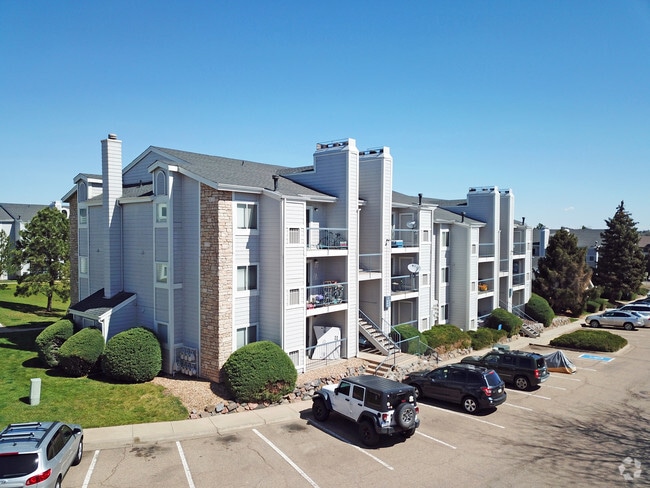

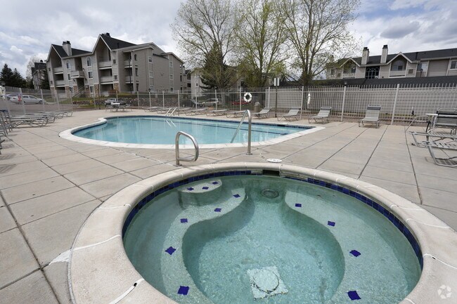

Property Detail
7777 E Yale Ave
1973-28-3-27-002
SUBDIVISIONCD 035346 SUBDIVISIONNAME HUNTERS RUN 2ND FLG BLOCK 001 LOT 001 LOT 1 BLK 1 HUNTERS RUN 2ND FLG TOG WITH LOT 1 BLK 1 HUNTERS RUN 3 A & LOT 1 BLK 1 HUNTERS RUN 3 B
Apartment
Denver
PUD
Colorado
B and X Area of moderate flood hazard, usually the area between the limits of the 100-year and 500-year floods.
001,1
2024
20.38 AC
2025
Cherry Creek South
087301
Denver
506,272 SF
Denver-Aurora-Centennial, CO
NEARBY LISTINGS FOR SALE OR LEASE
DEMOGRAPHICS near 7777 E Yale Ave
1 mile
3 mile
5 mile
2025 Total Population
20,943
174,011
420,348
2030 Population
21,408
177,740
429,107
Pop Growth 2025-2030
+ 2.22%
+ 2.14%
+ 2.08%
Average Age
39
40
40
2025 Total Households
9,437
81,486
186,915
HH Growth 2025-2030
+ 2.33%
+ 2.20%
+ 2.26%
Median Household Inc
$79,266
$78,657
$88,323
Avg Household Size
2.10
2.10
2.20
2025 Avg HH Vehicles
2.00
2.00
2.00
Median Home Value
$662,640
$581,368
$654,843
Median Year Built
1980
1978
1978
Nearby Places
Map Layers
Map Styles
 Street
 Aerial
Transit
 Traffic
 Biking
Places
Listings with unknown addresses are not visible on the map
- Restaurants
- Banks
- Shops
- Fitness
- Groceries
PUBLIC TRANSPORTATION
COMMUTER RAIL
Central Park Station Track 1 (Union Station to Denver Airport Station - Regional Transportation District)
Drive
Walk
Distance
Central Park Station Track 1 (Union Station to Denver Airport Station - Regional Transportation District)
18 min
8.5 mi
Central Park Station Track 2 (Union Station to Denver Airport Station - Regional Transportation District)
Drive
Walk
Distance
Central Park Station Track 2 (Union Station to Denver Airport Station - Regional Transportation District)
19 min
8.6 mi
AIRPORT
Denver International
Drive
Walk
Distance
Denver International
34 min
24.6 mi
Freight Ports
Tulsa Port Of Catoosa
Drive
Walk
Distance
Tulsa Port Of Catoosa
731 min
707.3 mi
Nearby Properties
Address
Land Use
TOTAL SIZE
Lot Size
Zoning
Address
Land Use
TOTAL SIZE
Lot Size
Zoning
508,135 SF
6.99 AC
C-RX
Address
Land Use
TOTAL SIZE
Lot Size
Zoning
277,917 SF
12.59 AC
B-4
Address
Land Use
TOTAL SIZE
Lot Size
Zoning
470,605 SF
13.68 AC
B-8
Address
Land Use
TOTAL SIZE
Lot Size
Zoning
389,502 SF
2.32 AC
T-MU-30
Address
Land Use
TOTAL SIZE
Lot Size
Zoning
163,033 SF
5.94 AC
PUD
Address
Land Use
TOTAL SIZE
Lot Size
Zoning
898,130 SF
89.50 AC
Address
Land Use
TOTAL SIZE
Lot Size
Zoning
87,207 SF
Address
Land Use
TOTAL SIZE
Lot Size
Zoning
240,545 SF
2.35 AC
C-MX-20
Address
Land Use
TOTAL SIZE
Lot Size
Zoning
394,111 SF
0.91 AC
T-MU
Address
Land Use
TOTAL SIZE
Lot Size
Zoning
355,464 SF
6.20 AC
B-8
Address
Land Use
TOTAL SIZE
Lot Size
Zoning
416,096 SF
5.20 AC
C-MX-20
Address
Land Use
TOTAL SIZE
Lot Size
Zoning
70,296 SF
4.96 AC
Address
Land Use
TOTAL SIZE
Lot Size
Zoning
74,888 SF
4.35 AC
AMU
Address
Land Use
TOTAL SIZE
Lot Size
Zoning
320,589 SF
33.33 AC
S-SU-F
Address
Land Use
TOTAL SIZE
Lot Size
Zoning
14,878 SF
34.55 AC
OS-B
Address
Land Use
TOTAL SIZE
Lot Size
Zoning
83,951 SF
0.30 AC
R2
Address
Land Use
TOTAL SIZE
Lot Size
Zoning
313,836 SF
5.90 AC
B-8
Address
Land Use
TOTAL SIZE
Lot Size
Zoning
50,106 SF
1.67 AC
RB1
Address
Land Use
TOTAL SIZE
Lot Size
Zoning
372,593 SF
5.61 AC
S-MX-12
Address
Land Use
TOTAL SIZE
Lot Size
Zoning
191,152 SF
1.26 AC
S-MX-12
Address
Land Use
TOTAL SIZE
Lot Size
Zoning
231,867 SF
19.33 AC
S-MX-3A
Address
Land Use
TOTAL SIZE
Lot Size
Zoning
613,600 SF
29.40 AC
R-3
Address
Land Use
TOTAL SIZE
Lot Size
Zoning
40,268 SF
8.35 AC
S-SU-F
Address
Land Use
TOTAL SIZE
Lot Size
Zoning
396,041 SF
6.77 AC
B-8
Address
Land Use
TOTAL SIZE
Lot Size
Zoning
169,350 SF
19.74 AC
H-1-B
Address
Land Use
TOTAL SIZE
Lot Size
Zoning
48,630 SF
3.31 AC
C-MX-8
Address
Land Use
TOTAL SIZE
Lot Size
Zoning
34,413 SF
2.52 AC
S-MX-5
Address
Land Use
TOTAL SIZE
Lot Size
Zoning
112,322 SF
10.26 AC
S-CC-3
Address
Land Use
TOTAL SIZE
Lot Size
Zoning
18,872 SF
11.34 AC
E-SU
Address
Land Use
TOTAL SIZE
Lot Size
Zoning
129,234 SF
0.95 AC
T-MU-30
The World's #1 Commercial Real Estate Marketplace
Connect with us
© 2026 CoStar Group
The information above has been obtained from sources believed reliable. While we do not doubt its accuracy we have not verified it and make no guarantee, warranty or representation about it. It is your responsibility to independently confirm its accuracy and completeness. Any projections, opinions, assumptions, or estimates used are for example only and do not represent the current or future performance of the property. The value of this transaction to you depends on tax and other factors which should be evaluated by your tax, financial, and legal advisors. You and your advisors should conduct a careful, independent investigation of the property to determine to your satisfaction the suitability of the property for your needs.