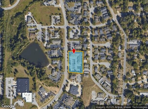
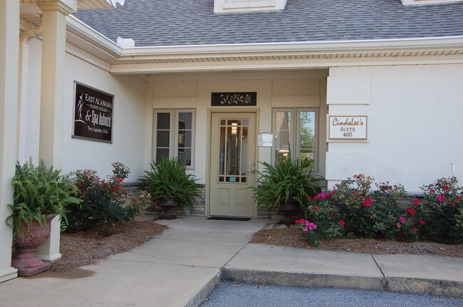
Property Record
778 N Dean Rd, Auburn, AL 36830

NEARBY LISTINGS FOR SALE OR LEASE
Property Detail
778 N Dean Rd
Auburn-Opelika, AL
Central Park S/D 2Nd Addition
09-04-20-1-000-226.000
LOT 20-21 CENTRAL PARK 2ND ADDITION 1ST REVISION TO LOTS 21-22 PLAT 28-174 SEC 20 T19N R26E KOUL PROFESSIONAL CENTER A CONDOM
Vacantlandnec
Lee
X
Alabama
01081C0202H
20
0
1.34 AC
2025
Lee County
040904
Columbus GA
DEMOGRAPHICS near 778 N Dean Rd
1 Mile
3 Mile
5 Mile
2024 Total Population
10,277
52,818
92,096
2029 Population
11,107
57,297
100,400
Pop Growth 2024-2029
+ 8.08%
+ 8.48%
+ 9.02%
Average Age
33
33
34
2024 Total Households
4,384
21,490
37,010
HH Growth 2024-2029
+ 7.89%
+ 8.80%
+ 9.17%
Median Household Inc
$49,509
$45,578
$46,614
Avg Household Size
2.30
2.20
2.30
2024 Avg HH Vehicles
2.00
2.00
2.00
Median Home Value
$247,965
$282,988
$273,439
Median Year Built
2000
1995
1997
Nearby Places
Map Layers
Map Styles
 Street
 Aerial
- Restaurants
- Banks
- Shops
- Fitness
- Groceries
PUBLIC TRANSPORTATION
AIRPORT
Columbus
DRIVE
WALK
Distance
Columbus
54 min
38.8 mi
SALE & LEASE HISTORY
LISTING DATE
SALE/LEASE

Sep 25, 2016
For Lease
Sep 24, 2016
For Sale
Apr 11, 2024
For Lease
Nearby Properties
Address
Land Use
TOTAL SIZE
Lot Size
Zoning
Address
Land Use
TOTAL SIZE
Lot Size
Zoning
257,779 SF
1.57 AC
Address
Land Use
TOTAL SIZE
Lot Size
Zoning
1,724 SF
3.47 AC
Address
Land Use
TOTAL SIZE
Lot Size
Zoning
330,891 SF
3.45 AC
Address
Land Use
TOTAL SIZE
Lot Size
Zoning
357,901 SF
3.47 AC
Address
Land Use
TOTAL SIZE
Lot Size
Zoning
328,847 SF
3.27 AC
Address
Land Use
TOTAL SIZE
Lot Size
Zoning
143,367 SF
5.90 AC
Address
Land Use
TOTAL SIZE
Lot Size
Zoning
Address
Land Use
TOTAL SIZE
Lot Size
Zoning
557,207 SF
2.45 AC
Address
Land Use
TOTAL SIZE
Lot Size
Zoning
133,954 SF
12.28 AC
Address
Land Use
TOTAL SIZE
Lot Size
Zoning
12,040 SF
23.60 AC
Address
Land Use
TOTAL SIZE
Lot Size
Zoning
176,021 SF
1.39 AC
Address
Land Use
TOTAL SIZE
Lot Size
Zoning
11,250 SF
11.34 AC
Address
Land Use
TOTAL SIZE
Lot Size
Zoning
219,562 SF
2.86 AC
Address
Land Use
TOTAL SIZE
Lot Size
Zoning
271,018 SF
5.54 AC
Address
Land Use
TOTAL SIZE
Lot Size
Zoning
160,743 SF
Address
Land Use
TOTAL SIZE
Lot Size
Zoning
123,827 SF
0.74 AC
Address
Land Use
TOTAL SIZE
Lot Size
Zoning
13,615 SF
34.30 AC
Address
Land Use
TOTAL SIZE
Lot Size
Zoning
247,676 SF
1.57 AC
Address
Land Use
TOTAL SIZE
Lot Size
Zoning
19,766 SF
12.22 AC
Address
Land Use
TOTAL SIZE
Lot Size
Zoning
15,876 SF
30.47 AC
Address
Land Use
TOTAL SIZE
Lot Size
Zoning
968 SF
4.36 AC
Address
Land Use
TOTAL SIZE
Lot Size
Zoning
4,840 SF
12.80 AC
Address
Land Use
TOTAL SIZE
Lot Size
Zoning
18,540 SF
12.99 AC
Address
Land Use
TOTAL SIZE
Lot Size
Zoning
11,076 SF
15.79 AC
Address
Land Use
TOTAL SIZE
Lot Size
Zoning
77,104 SF
5.42 AC
Address
Land Use
TOTAL SIZE
Lot Size
Zoning
7,700 SF
13.75 AC
Address
Land Use
TOTAL SIZE
Lot Size
Zoning
22,683 SF
7 AC
Address
Land Use
TOTAL SIZE
Lot Size
Zoning
0.88 AC
Address
Land Use
TOTAL SIZE
Lot Size
Zoning
1.71 AC
Address
Land Use
TOTAL SIZE
Lot Size
Zoning
1.69 AC
The World's #1 Commercial Real Estate Marketplace
Connect with us
© 2025 CoStar Group
The information above has been obtained from sources believed reliable. While we do not doubt its accuracy we have not verified it and make no guarantee, warranty or representation about it. It is your responsibility to independently confirm its accuracy and completeness. Any projections, opinions, assumptions, or estimates used are for example only and do not represent the current or future performance of the property. The value of this transaction to you depends on tax and other factors which should be evaluated by your tax, financial, and legal advisors. You and your advisors should conduct a careful, independent investigation of the property to determine to your satisfaction the suitability of the property for your needs.