Property Record
77/83 Highway, Harlingen, TX 78550
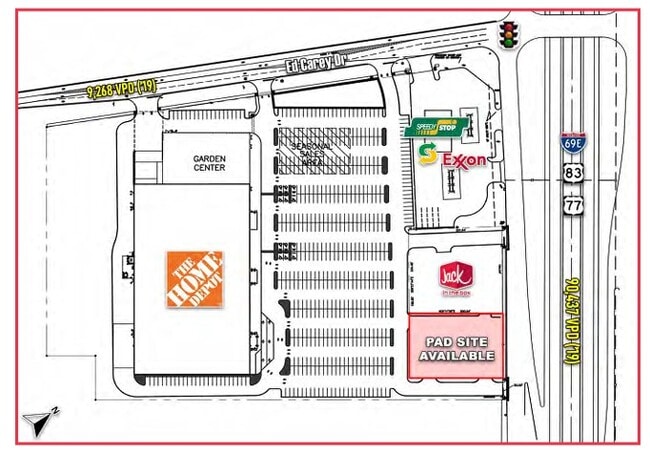

Current Lease Availabilities
Property Detail
77/83 Highway
Brownsville/Harlingen
HOME DEPOT - HARLINGEN SUBDIVISION LOT 3 BLK 185 (CAB 1 SLOT 1768-B CCMR)
Brownsville-Harlingen, TX
CAMERON
230689-0000-003000
Texas
Commercialacreage
3
2024
0.67 AC
2025
Greater Harlingen
010700
NEARBY LISTINGS FOR SALE OR LEASE
DEMOGRAPHICS near 77/83 Highway
1 mile
3 mile
5 mile
2025 Total Population
5,953
46,843
100,072
2030 Population
6,080
47,883
102,604
Pop Growth 2025-2030
+ 2.13%
+ 2.22%
+ 2.53%
Average Age
38
38
37
2025 Total Households
2,132
16,012
34,002
HH Growth 2025-2030
+ 2.20%
+ 2.25%
+ 2.65%
Median Household Inc
$38,828
$49,627
$51,168
Avg Household Size
2.60
2.80
2.80
2025 Avg HH Vehicles
2.00
2.00
2.00
Median Home Value
$174,672
$129,296
$136,006
Median Year Built
1989
1982
1985
Nearby Places
Map Layers
Map Styles
 Street
 Aerial
Layers
 Traffic
 Biking
Places
Listings with unknown addresses are not visible on the map
- Restaurants
- Banks
- Shops
- Fitness
- Groceries
PUBLIC TRANSPORTATION
AIRPORT
Valley International
Drive
Walk
Distance
Valley International
18 min
6.8 mi
Brownsville/South Padre Island International
Drive
Walk
Distance
Brownsville/South Padre Island International
33 min
25.1 mi
McAllen International
Drive
Walk
Distance
McAllen International
47 min
38.2 mi
Nearby Properties
Address
Land Use
TOTAL SIZE
Lot Size
Zoning
Address
Land Use
TOTAL SIZE
Lot Size
Zoning
758,640 SF
11.31 AC
Address
Land Use
TOTAL SIZE
Lot Size
Zoning
427,448 SF
6.94 AC
Address
Land Use
TOTAL SIZE
Lot Size
Zoning
89,797 SF
7.90 AC
Address
Land Use
TOTAL SIZE
Lot Size
Zoning
186,716 SF
13.31 AC
C
Address
Land Use
TOTAL SIZE
Lot Size
Zoning
293,886 SF
23.57 AC
Address
Land Use
TOTAL SIZE
Lot Size
Zoning
171,714 SF
16.03 AC
C
Address
Land Use
TOTAL SIZE
Lot Size
Zoning
391,617 SF
23.20 AC
C
Address
Land Use
TOTAL SIZE
Lot Size
Zoning
159,787 SF
10.66 AC
Address
Land Use
TOTAL SIZE
Lot Size
Zoning
176,365 SF
14.65 AC
Address
Land Use
TOTAL SIZE
Lot Size
Zoning
135,258 SF
4.26 AC
C
Address
Land Use
TOTAL SIZE
Lot Size
Zoning
148,596 SF
1 AC
Address
Land Use
TOTAL SIZE
Lot Size
Zoning
72,063 SF
2.29 AC
Address
Land Use
TOTAL SIZE
Lot Size
Zoning
118,561 SF
6.32 AC
C
Address
Land Use
TOTAL SIZE
Lot Size
Zoning
77,189 SF
3.28 AC
Address
Land Use
TOTAL SIZE
Lot Size
Zoning
177,812 SF
21.40 AC
C
Address
Land Use
TOTAL SIZE
Lot Size
Zoning
62,764 SF
10 AC
Address
Land Use
TOTAL SIZE
Lot Size
Zoning
61,920 SF
5.60 AC
C
Address
Land Use
TOTAL SIZE
Lot Size
Zoning
63,381 SF
3.15 AC
Address
Land Use
TOTAL SIZE
Lot Size
Zoning
155,425 SF
20.77 AC
C
Address
Land Use
TOTAL SIZE
Lot Size
Zoning
1,152 SF
44.60 AC
C
Address
Land Use
TOTAL SIZE
Lot Size
Zoning
138,862 SF
15.82 AC
Address
Land Use
TOTAL SIZE
Lot Size
Zoning
206,973 SF
12.77 AC
Address
Land Use
TOTAL SIZE
Lot Size
Zoning
230,267 SF
7.85 AC
C
Address
Land Use
TOTAL SIZE
Lot Size
Zoning
180,838 SF
12.56 AC
C
Address
Land Use
TOTAL SIZE
Lot Size
Zoning
79,466 SF
6.23 AC
C
Address
Land Use
TOTAL SIZE
Lot Size
Zoning
78,223 SF
20.85 AC
Address
Land Use
TOTAL SIZE
Lot Size
Zoning
47,558 SF
7 AC
Address
Land Use
TOTAL SIZE
Lot Size
Zoning
90,376 SF
1.93 AC
Address
Land Use
TOTAL SIZE
Lot Size
Zoning
176,627 SF
12.45 AC
A-C
Address
Land Use
TOTAL SIZE
Lot Size
Zoning
42,557 SF
1.74 AC
C
The World's #1 Commercial Real Estate Marketplace
Connect with us
© 2026 CoStar Group
The information above has been obtained from sources believed reliable. While we do not doubt its accuracy we have not verified it and make no guarantee, warranty or representation about it. It is your responsibility to independently confirm its accuracy and completeness. Any projections, opinions, assumptions, or estimates used are for example only and do not represent the current or future performance of the property. The value of this transaction to you depends on tax and other factors which should be evaluated by your tax, financial, and legal advisors. You and your advisors should conduct a careful, independent investigation of the property to determine to your satisfaction the suitability of the property for your needs.