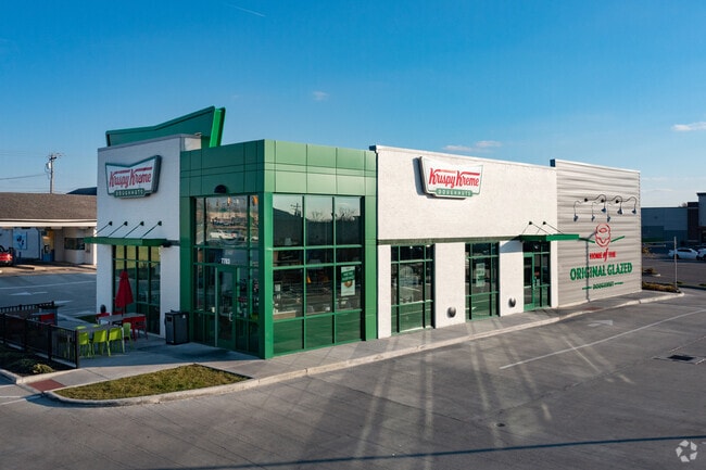
Property Record
7783 Tylersville Rd, West Chester, OH 45069

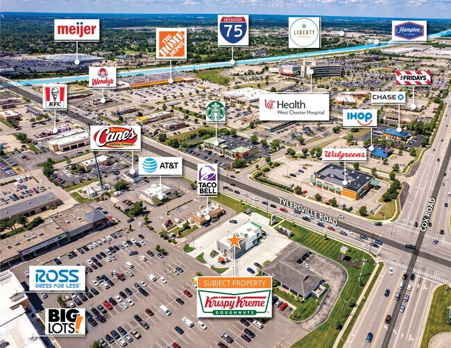
NEARBY LISTINGS FOR SALE OR LEASE
Property Detail
7783 Tylersville Rd
M5620-180-000-035
Kingsgate Sub
Restaurantdrivein
170 ENT KINGSGATE SUB ADD NO 5
X
Butler
39165C0201F
Ohio
2024
0.70 AC
2025
Butler County
011126
Cincinnati/Dayton
3,600 SF
Cincinnati, OH-KY-IN
DEMOGRAPHICS near 7783 Tylersville Rd
1 Mile
3 Mile
5 Mile
2024 Total Population
5,762
63,452
147,140
2029 Population
5,847
66,115
153,261
Pop Growth 2024-2029
+ 1.48%
+ 4.20%
+ 4.16%
Average Age
42
40
40
2024 Total Households
2,201
22,972
53,567
HH Growth 2024-2029
+ 1.36%
+ 4.03%
+ 4.08%
Median Household Inc
$108,651
$112,483
$114,380
Avg Household Size
2.50
2.70
2.70
2024 Avg HH Vehicles
2.00
2.00
2.00
Median Home Value
$271,394
$289,533
$304,096
Median Year Built
1989
1991
1992
Nearby Places
Map Layers
Map Styles
 Street
 Aerial
- Restaurants
- Banks
- Shops
- Fitness
- Groceries
PUBLIC TRANSPORTATION
AIRPORT
Cincinnati/Northern Kentucky International
DRIVE
WALK
Distance
Cincinnati/Northern Kentucky International
55 min
36.0 mi
Freight Ports
Port of Toledo
DRIVE
WALK
Distance
Port of Toledo
214 min
184.2 mi
SALE & LEASE HISTORY
LISTING DATE
SALE/LEASE

Jun 30, 2021
For Sale
Aug 01, 2022
For Sale
Nearby Properties
Address
Land Use
TOTAL SIZE
Lot Size
Zoning
Address
Land Use
TOTAL SIZE
Lot Size
Zoning
21,549 SF
30.60 AC
Address
Land Use
TOTAL SIZE
Lot Size
Zoning
1,764 SF
17.27 AC
Address
Land Use
TOTAL SIZE
Lot Size
Zoning
431,936 SF
14.27 AC
Address
Land Use
TOTAL SIZE
Lot Size
Zoning
136,681 SF
22.56 AC
Address
Land Use
TOTAL SIZE
Lot Size
Zoning
300,943 SF
23.01 AC
Address
Land Use
TOTAL SIZE
Lot Size
Zoning
63,366 SF
48.54 AC
Address
Land Use
TOTAL SIZE
Lot Size
Zoning
Address
Land Use
TOTAL SIZE
Lot Size
Zoning
7,230 SF
40 AC
Address
Land Use
TOTAL SIZE
Lot Size
Zoning
179,048 SF
12.32 AC
Address
Land Use
TOTAL SIZE
Lot Size
Zoning
62.02 AC
Address
Land Use
TOTAL SIZE
Lot Size
Zoning
1,248 SF
21.67 AC
Address
Land Use
TOTAL SIZE
Lot Size
Zoning
188,177 SF
4.62 AC
Address
Land Use
TOTAL SIZE
Lot Size
Zoning
35,188 SF
38.49 AC
Address
Land Use
TOTAL SIZE
Lot Size
Zoning
262,173 SF
2.32 AC
Address
Land Use
TOTAL SIZE
Lot Size
Zoning
13,532 SF
3.19 AC
Address
Land Use
TOTAL SIZE
Lot Size
Zoning
158,680 SF
22.49 AC
Address
Land Use
TOTAL SIZE
Lot Size
Zoning
82,493 SF
26.57 AC
Address
Land Use
TOTAL SIZE
Lot Size
Zoning
14,970 SF
28.54 AC
Address
Land Use
TOTAL SIZE
Lot Size
Zoning
178,374 SF
2.14 AC
Address
Land Use
TOTAL SIZE
Lot Size
Zoning
107,304 SF
0.70 AC
Address
Land Use
TOTAL SIZE
Lot Size
Zoning
Address
Land Use
TOTAL SIZE
Lot Size
Zoning
52,018 SF
7.37 AC
Address
Land Use
TOTAL SIZE
Lot Size
Zoning
159,456 SF
19.19 AC
Address
Land Use
TOTAL SIZE
Lot Size
Zoning
78,895 SF
5.98 AC
Address
Land Use
TOTAL SIZE
Lot Size
Zoning
222,920 SF
22.73 AC
Address
Land Use
TOTAL SIZE
Lot Size
Zoning
46,835 SF
4.43 AC
Address
Land Use
TOTAL SIZE
Lot Size
Zoning
197,448 SF
2.73 AC
Address
Land Use
TOTAL SIZE
Lot Size
Zoning
88,569 SF
3.67 AC
ADV
Address
Land Use
TOTAL SIZE
Lot Size
Zoning
21,439 SF
20.23 AC
Address
Land Use
TOTAL SIZE
Lot Size
Zoning
49,553 SF
40.74 AC
The World's #1 Commercial Real Estate Marketplace
Connect with us
© 2026 CoStar Group
The information above has been obtained from sources believed reliable. While we do not doubt its accuracy we have not verified it and make no guarantee, warranty or representation about it. It is your responsibility to independently confirm its accuracy and completeness. Any projections, opinions, assumptions, or estimates used are for example only and do not represent the current or future performance of the property. The value of this transaction to you depends on tax and other factors which should be evaluated by your tax, financial, and legal advisors. You and your advisors should conduct a careful, independent investigation of the property to determine to your satisfaction the suitability of the property for your needs.