Property Record
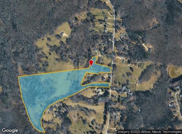
779 Bill Watkins Rd, Hoschton, GA 30548

NEARBY LISTINGS FOR SALE OR LEASE
Property Detail
779 Bill Watkins Rd
114-007
TRACT 2 PLAT BOOK 76 PAGE 179 EXC 1.5 AC
Privatepreserveopenspacevacantlandforestlandconservation
Jackson
A
Georgia
13013C0075D
26.80 AC
2025
Jackson County
2024
Atlanta
010107
Jefferson, GA
1,369 SF
DEMOGRAPHICS near 779 Bill Watkins Rd
1 Mile
3 Mile
5 Mile
2024 Total Population
886
12,717
37,921
2029 Population
1,124
16,096
46,773
Pop Growth 2024-2029
+ 26.86%
+ 26.57%
+ 23.34%
Average Age
39
39
39
2024 Total Households
274
4,253
12,957
HH Growth 2024-2029
+ 25.18%
+ 25.32%
+ 22.44%
Median Household Inc
$107,465
$103,727
$84,457
Avg Household Size
3.00
2.90
2.90
2024 Avg HH Vehicles
3.00
3.00
2.00
Median Home Value
$372,999
$355,534
$303,777
Median Year Built
2003
2005
2003
Nearby Places
Map Layers
Map Styles
 Street
 Aerial
- Restaurants
- Banks
- Shops
- Fitness
- Groceries
SALE & LEASE HISTORY
LISTING DATE
SALE/LEASE

Mar 30, 2018
For Sale
Nearby Properties
Address
Land Use
TOTAL SIZE
Lot Size
Zoning
Address
Land Use
TOTAL SIZE
Lot Size
Zoning
71,246 SF
10.10 AC
001
Address
Land Use
TOTAL SIZE
Lot Size
Zoning
572.63 AC
004
Address
Land Use
TOTAL SIZE
Lot Size
Zoning
224.76 AC
004
Address
Land Use
TOTAL SIZE
Lot Size
Zoning
173.05 AC
004
Address
Land Use
TOTAL SIZE
Lot Size
Zoning
20,634 SF
9.80 AC
003
Address
Land Use
TOTAL SIZE
Lot Size
Zoning
35.12 AC
001
Address
Land Use
TOTAL SIZE
Lot Size
Zoning
325 AC
R-3
Address
Land Use
TOTAL SIZE
Lot Size
Zoning
44,870 SF
11.78 AC
M1
Address
Land Use
TOTAL SIZE
Lot Size
Zoning
10.96 AC
004
Address
Land Use
TOTAL SIZE
Lot Size
Zoning
5.95 AC
CRC
Address
Land Use
TOTAL SIZE
Lot Size
Zoning
10.34 AC
CRC
Address
Land Use
TOTAL SIZE
Lot Size
Zoning
9.80 AC
004
Address
Land Use
TOTAL SIZE
Lot Size
Zoning
3,150 SF
004
Address
Land Use
TOTAL SIZE
Lot Size
Zoning
46,884 SF
4.06 AC
004
Address
Land Use
TOTAL SIZE
Lot Size
Zoning
50,316 SF
2.78 AC
M
Address
Land Use
TOTAL SIZE
Lot Size
Zoning
2,090 SF
130.26 AC
A2
Address
Land Use
TOTAL SIZE
Lot Size
Zoning
6,800 SF
7.30 AC
C-3
Address
Land Use
TOTAL SIZE
Lot Size
Zoning
27,000 SF
5.68 AC
MI
Address
Land Use
TOTAL SIZE
Lot Size
Zoning
14,215 SF
2.26 AC
CRC
Address
Land Use
TOTAL SIZE
Lot Size
Zoning
8,662 SF
1.27 AC
CRC
Address
Land Use
TOTAL SIZE
Lot Size
Zoning
10,080 SF
8.30 AC
A1
Address
Land Use
TOTAL SIZE
Lot Size
Zoning
7,296 SF
2.48 AC
Address
Land Use
TOTAL SIZE
Lot Size
Zoning
4,706 SF
3.07 AC
002
Address
Land Use
TOTAL SIZE
Lot Size
Zoning
15,000 SF
3.13 AC
M1
Address
Land Use
TOTAL SIZE
Lot Size
Zoning
12,906 SF
2.04 AC
CRC
Address
Land Use
TOTAL SIZE
Lot Size
Zoning
9.78 AC
A2
Address
Land Use
TOTAL SIZE
Lot Size
Zoning
6,968 SF
19.32 AC
HRC
Address
Land Use
TOTAL SIZE
Lot Size
Zoning
20.45 AC
001
Address
Land Use
TOTAL SIZE
Lot Size
Zoning
106.36 AC
004
Address
Land Use
TOTAL SIZE
Lot Size
Zoning
5,037 SF
1.59 AC
HRC
The World's #1 Commercial Real Estate Marketplace
Connect with us
© 2025 CoStar Group
The information above has been obtained from sources believed reliable. While we do not doubt its accuracy we have not verified it and make no guarantee, warranty or representation about it. It is your responsibility to independently confirm its accuracy and completeness. Any projections, opinions, assumptions, or estimates used are for example only and do not represent the current or future performance of the property. The value of this transaction to you depends on tax and other factors which should be evaluated by your tax, financial, and legal advisors. You and your advisors should conduct a careful, independent investigation of the property to determine to your satisfaction the suitability of the property for your needs.