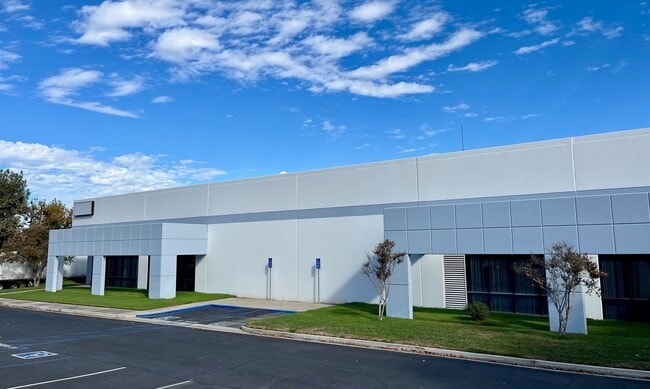
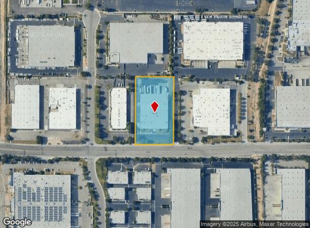
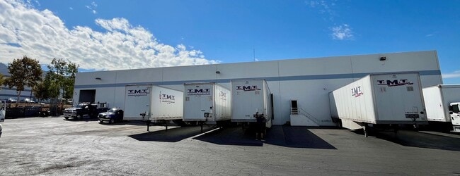
Property Record
779 Palmyrita Ave, Riverside, CA 92507
Current Lease Availabilities
NEARBY LISTINGS FOR SALE OR LEASE
Property Detail
779 Palmyrita Ave
255-120-023
2.38 ACRES IN PAR 2 PM 185/031 PM 28040
Lightindustrial
Riverside
X
California
06065C0065H
2
2024
2.38 AC
2025
Riverside
042209
Inland Empire (California)
39,922 SF
Riverside-San Bernardino-Ontario, CA
DEMOGRAPHICS near 779 Palmyrita Ave
1 Mile
3 Mile
5 Mile
2024 Total Population
4,344
80,323
199,690
2029 Population
4,623
83,951
208,318
Pop Growth 2024-2029
+ 6.42%
+ 4.52%
+ 4.32%
Average Age
34
33
35
2024 Total Households
1,208
24,042
62,651
HH Growth 2024-2029
+ 6.04%
+ 4.23%
+ 4.12%
Median Household Inc
$84,769
$69,145
$72,287
Avg Household Size
3.50
2.90
3.00
2024 Avg HH Vehicles
3.00
2.00
2.00
Median Home Value
$587,500
$426,584
$446,885
Median Year Built
1984
1977
1977
Nearby Places
- Restaurants
- Banks
- Shops
- Fitness
- Groceries
PUBLIC TRANSPORTATION
COMMUTER RAIL
Riverside-Hunter Park/Ucr (Metrolink 91-Perris Valley Line - Metrolink Trains)
DRIVE
WALK
Distance
Riverside-Hunter Park/Ucr (Metrolink 91-Perris Valley Line - Metrolink Trains)
3 min
18 min
0.9 mi
Riverside-Downtown (91 Line - Southern California Regional Rail Authority (Metrolink), Inland Empire-Orange County Line - Southern California Regional Rail Authority (Metrolink), Riverside Line - Southern California Regional Rail Authority (Metrolink))
DRIVE
WALK
Distance
Riverside-Downtown (91 Line - Southern California Regional Rail Authority (Metrolink), Inland Empire-Orange County Line - Southern California Regional Rail Authority (Metrolink), Riverside Line - Southern California Regional Rail Authority (Metrolink))
9 min
4.3 mi
AIRPORT
Ontario International
DRIVE
WALK
Distance
Ontario International
27 min
19.3 mi
Freight Ports
Port of Long Beach
DRIVE
WALK
Distance
Port of Long Beach
77 min
60.1 mi
Nearby Properties
Address
Land Use
TOTAL SIZE
Lot Size
Zoning
Address
Land Use
TOTAL SIZE
Lot Size
Zoning
798,304 SF
42.64 AC
AMSP
Address
Land Use
TOTAL SIZE
Lot Size
Zoning
1,009,120 SF
35.22 AC
Address
Land Use
TOTAL SIZE
Lot Size
Zoning
494,575 SF
25.33 AC
MP
Address
Land Use
TOTAL SIZE
Lot Size
Zoning
599,735 SF
33.25 AC
AMSP
Address
Land Use
TOTAL SIZE
Lot Size
Zoning
369,842 SF
16.35 AC
Address
Land Use
TOTAL SIZE
Lot Size
Zoning
411,707 SF
19.34 AC
Address
Land Use
TOTAL SIZE
Lot Size
Zoning
447,190 SF
21.08 AC
Address
Land Use
TOTAL SIZE
Lot Size
Zoning
26,879 SF
16.27 AC
R3
Address
Land Use
TOTAL SIZE
Lot Size
Zoning
217,036 SF
1.66 AC
C2
Address
Land Use
TOTAL SIZE
Lot Size
Zoning
182,624 SF
16.07 AC
Address
Land Use
TOTAL SIZE
Lot Size
Zoning
245,476 SF
15.61 AC
Address
Land Use
TOTAL SIZE
Lot Size
Zoning
156,241 SF
2.55 AC
Address
Land Use
TOTAL SIZE
Lot Size
Zoning
55.22 AC
AMSP
Address
Land Use
TOTAL SIZE
Lot Size
Zoning
36,010 SF
11.76 AC
R3
Address
Land Use
TOTAL SIZE
Lot Size
Zoning
182,446 SF
9.01 AC
Address
Land Use
TOTAL SIZE
Lot Size
Zoning
134,944 SF
2.52 AC
Address
Land Use
TOTAL SIZE
Lot Size
Zoning
415,990 SF
5.16 AC
Address
Land Use
TOTAL SIZE
Lot Size
Zoning
307,163 SF
16.65 AC
Address
Land Use
TOTAL SIZE
Lot Size
Zoning
230,063 SF
11.06 AC
Address
Land Use
TOTAL SIZE
Lot Size
Zoning
304,560 SF
16.79 AC
IP
Address
Land Use
TOTAL SIZE
Lot Size
Zoning
122,738 SF
10.77 AC
Address
Land Use
TOTAL SIZE
Lot Size
Zoning
Address
Land Use
TOTAL SIZE
Lot Size
Zoning
156,998 SF
11.90 AC
MP
Address
Land Use
TOTAL SIZE
Lot Size
Zoning
8.81 AC
R3S3
Address
Land Use
TOTAL SIZE
Lot Size
Zoning
106,065 SF
6.50 AC
MP
Address
Land Use
TOTAL SIZE
Lot Size
Zoning
17,542 SF
8.27 AC
R1
The World's #1 Commercial Real Estate Marketplace
Connect with us
© 2025 CoStar Group
The information above has been obtained from sources believed reliable. While we do not doubt its accuracy we have not verified it and make no guarantee, warranty or representation about it. It is your responsibility to independently confirm its accuracy and completeness. Any projections, opinions, assumptions, or estimates used are for example only and do not represent the current or future performance of the property. The value of this transaction to you depends on tax and other factors which should be evaluated by your tax, financial, and legal advisors. You and your advisors should conduct a careful, independent investigation of the property to determine to your satisfaction the suitability of the property for your needs.