Property Record
7796 Greenlee Dr, Caledonia, IL 61011
Save to a Folder
{{folder.Name}}
{{folder.ListingIds.length}} Properties
{{folder.ListingIds.length}} Property
Create a New Folder
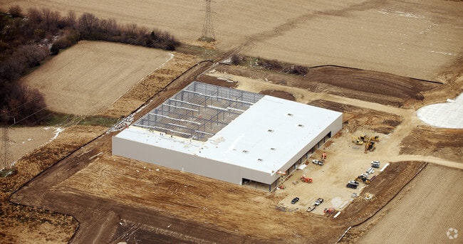
Property Detail
7796 Greenlee Dr
Rockford, IL
BEG SW COR LT 7 PARK 90 SUB PLAT 3 THSE 482.7 FT SE 313.8 FT E 568.06 FT N376.67 FT E 558 FT N 283 FT W 685.32 FT NWLY 154.64 FT TH W 643.59 FT TO POB
08-14-400-021
WINNEBAGO
Industrialgeneral
Illinois
B and X Area of moderate flood hazard, usually the area between the limits of the 100-year and 500-year floods.
7
2025
15.93 AC
2025
I-39 Cor/Winnebago Cy
003806
Chicago
NEARBY LISTINGS FOR SALE OR LEASE
DEMOGRAPHICS near 7796 Greenlee Dr
1 mile
3 mile
5 mile
2025 Total Population
51
12,444
58,807
2030 Population
51
12,476
59,015
Pop Growth 2025-2030
0.00%
+ 0.26%
+ 0.35%
Average Age
42
42
42
2025 Total Households
19
4,787
23,358
HH Growth 2025-2030
0.00%
+ 0.31%
+ 0.35%
Median Household Inc
$140,624
$96,698
$85,921
Avg Household Size
2.70
2.60
2.50
2025 Avg HH Vehicles
2.00
2.00
2.00
Median Home Value
$285,713
$230,609
$196,807
Median Year Built
1989
1999
1991
Nearby Places
Map Layers
Map Styles
 Street
 Aerial
Layers
 Traffic
 Biking
Places
Listings with unknown addresses are not visible on the map
- Restaurants
- Banks
- Shops
- Fitness
- Groceries
PUBLIC TRANSPORTATION
AIRPORT
Chicago/Rockford International
Drive
Walk
Distance
Chicago/Rockford International
34 min
22.3 mi
Freight Ports
Port Milwaukee
Drive
Walk
Distance
Port Milwaukee
99 min
82.8 mi
Nearby Properties
Address
Land Use
TOTAL SIZE
Lot Size
Zoning
Address
Land Use
TOTAL SIZE
Lot Size
Zoning
105,664 SF
13.34 AC
Address
Land Use
TOTAL SIZE
Lot Size
Zoning
192,604 SF
17.05 AC
Address
Land Use
TOTAL SIZE
Lot Size
Zoning
90,000 SF
7.04 AC
SI - SING
Address
Land Use
TOTAL SIZE
Lot Size
Zoning
175,502 SF
18.15 AC
Address
Land Use
TOTAL SIZE
Lot Size
Zoning
Address
Land Use
TOTAL SIZE
Lot Size
Zoning
103,326 SF
10.52 AC
Address
Land Use
TOTAL SIZE
Lot Size
Zoning
Address
Land Use
TOTAL SIZE
Lot Size
Zoning
80,000 SF
4.82 AC
Address
Land Use
TOTAL SIZE
Lot Size
Zoning
85,350 SF
13.15 AC
Address
Land Use
TOTAL SIZE
Lot Size
Zoning
135,351 SF
19 AC
Address
Land Use
TOTAL SIZE
Lot Size
Zoning
79,643 SF
3.55 AC
Address
Land Use
TOTAL SIZE
Lot Size
Zoning
60,000 SF
4.59 AC
Address
Land Use
TOTAL SIZE
Lot Size
Zoning
55,200 SF
10.17 AC
Address
Land Use
TOTAL SIZE
Lot Size
Zoning
150,000 SF
5.64 AC
Address
Land Use
TOTAL SIZE
Lot Size
Zoning
52.23 AC
Address
Land Use
TOTAL SIZE
Lot Size
Zoning
30,090 SF
4.06 AC
Address
Land Use
TOTAL SIZE
Lot Size
Zoning
129,060 SF
7.09 AC
Address
Land Use
TOTAL SIZE
Lot Size
Zoning
16.60 AC
CG - COMM
Address
Land Use
TOTAL SIZE
Lot Size
Zoning
80,000 SF
6.63 AC
Address
Land Use
TOTAL SIZE
Lot Size
Zoning
9.98 AC
Address
Land Use
TOTAL SIZE
Lot Size
Zoning
29.92 AC
Address
Land Use
TOTAL SIZE
Lot Size
Zoning
38,200 SF
5.68 AC
Address
Land Use
TOTAL SIZE
Lot Size
Zoning
3,744 SF
12.71 AC
Address
Land Use
TOTAL SIZE
Lot Size
Zoning
11,930 SF
1.51 AC
Address
Land Use
TOTAL SIZE
Lot Size
Zoning
Address
Land Use
TOTAL SIZE
Lot Size
Zoning
Address
Land Use
TOTAL SIZE
Lot Size
Zoning
54,294 SF
9.60 AC
Address
Land Use
TOTAL SIZE
Lot Size
Zoning
10.95 AC
Address
Land Use
TOTAL SIZE
Lot Size
Zoning
2,897 SF
0.73 AC
Address
Land Use
TOTAL SIZE
Lot Size
Zoning
The World's #1 Commercial Real Estate Marketplace
Connect with us
© 2026 CoStar Group
The information above has been obtained from sources believed reliable. While we do not doubt its accuracy we have not verified it and make no guarantee, warranty or representation about it. It is your responsibility to independently confirm its accuracy and completeness. Any projections, opinions, assumptions, or estimates used are for example only and do not represent the current or future performance of the property. The value of this transaction to you depends on tax and other factors which should be evaluated by your tax, financial, and legal advisors. You and your advisors should conduct a careful, independent investigation of the property to determine to your satisfaction the suitability of the property for your needs.