Property Record
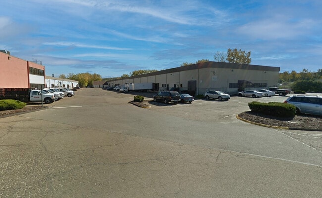
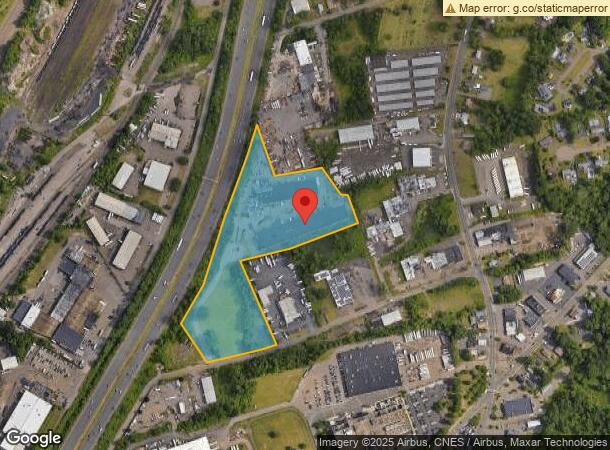
78 Rebeschi Dr, North Haven, CT 06473
Current Lease Availabilities
NEARBY LISTINGS FOR SALE OR LEASE
Property Detail
78 Rebeschi Dr
NRHV-000006-000000-000006
New Haven
Industrialgeneral
Connecticut
X
6
09009C0453K
10.92 AC
2025
North Haven
2025
Westchester/So Connecticut
167301
New Haven-Milford, CT
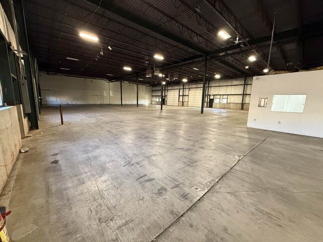
3,407 SF
DEMOGRAPHICS near 78 Rebeschi Dr
1 Mile
3 Mile
5 Mile
2024 Total Population
4,119
71,484
218,340
2029 Population
4,082
70,857
217,057
Pop Growth 2024-2029
(0.90%)
(0.88%)
(0.59%)
Average Age
40
41
39
2024 Total Households
1,576
29,421
87,457
HH Growth 2024-2029
(0.95%)
(0.75%)
(0.52%)
Median Household Inc
$68,815
$70,110
$64,220
Avg Household Size
2.60
2.30
2.30
2024 Avg HH Vehicles
2.00
2.00
1.00
Median Home Value
$252,458
$279,528
$263,990
Median Year Built
1961
1958
1961
Nearby Places
- Restaurants
- Banks
- Shops
- Fitness
- Groceries
PUBLIC TRANSPORTATION
COMMUTER RAIL
New Haven-State Street Station (New Haven Line - Metro-North Commuter Railroad Company (Metro-North))
DRIVE
WALK
Distance
New Haven-State Street Station (New Haven Line - Metro-North Commuter Railroad Company (Metro-North))
11 min
4.5 mi
DRIVE
WALK
Distance
11 min
5.1 mi
AIRPORT
Tweed/New Haven
DRIVE
WALK
Distance
Tweed/New Haven
17 min
7.4 mi
Nearby Properties
Address
Land Use
TOTAL SIZE
Lot Size
Zoning
Address
Land Use
TOTAL SIZE
Lot Size
Zoning
268,989 SF
22.59 AC
R20
Address
Land Use
TOTAL SIZE
Lot Size
Zoning
5.14 AC
H/C
Address
Land Use
TOTAL SIZE
Lot Size
Zoning
258,313 SF
23.50 AC
PDU 34
Address
Land Use
TOTAL SIZE
Lot Size
Zoning
78,878 SF
3.12 AC
RM2
Address
Land Use
TOTAL SIZE
Lot Size
Zoning
54 AC
R-3
Address
Land Use
TOTAL SIZE
Lot Size
Zoning
68,706 SF
3.34 AC
BA1
Address
Land Use
TOTAL SIZE
Lot Size
Zoning
7,345 SF
3.09 AC
IL/RM2
Address
Land Use
TOTAL SIZE
Lot Size
Zoning
296,444 SF
23.30 AC
T145
Address
Land Use
TOTAL SIZE
Lot Size
Zoning
72,007 SF
1.79 AC
RS2
Address
Land Use
TOTAL SIZE
Lot Size
Zoning
66.68 AC
IG80
Address
Land Use
TOTAL SIZE
Lot Size
Zoning
14.84 AC
T4
Address
Land Use
TOTAL SIZE
Lot Size
Zoning
60,374 SF
10.85 AC
T2
Address
Land Use
TOTAL SIZE
Lot Size
Zoning
163,505 SF
3.96 AC
BA1
Address
Land Use
TOTAL SIZE
Lot Size
Zoning
143,428 SF
13.08 AC
T4
Address
Land Use
TOTAL SIZE
Lot Size
Zoning
126,430 SF
10.63 AC
RM1
Address
Land Use
TOTAL SIZE
Lot Size
Zoning
31.34 AC
IL30
Address
Land Use
TOTAL SIZE
Lot Size
Zoning
17.71 AC
IL80
Address
Land Use
TOTAL SIZE
Lot Size
Zoning
25,015 SF
28.30 AC
RS2
Address
Land Use
TOTAL SIZE
Lot Size
Zoning
57,467 SF
3.72 AC
T4
Address
Land Use
TOTAL SIZE
Lot Size
Zoning
134,029 SF
27.54 AC
R20
Address
Land Use
TOTAL SIZE
Lot Size
Zoning
97,057 SF
2.78 AC
RM2
Address
Land Use
TOTAL SIZE
Lot Size
Zoning
85,000 SF
14 AC
R4
Address
Land Use
TOTAL SIZE
Lot Size
Zoning
23.40 AC
IG80
Address
Land Use
TOTAL SIZE
Lot Size
Zoning
14,133 SF
2.58 AC
RH1/RS
Address
Land Use
TOTAL SIZE
Lot Size
Zoning
27.36 AC
IL80
Address
Land Use
TOTAL SIZE
Lot Size
Zoning
132,592 SF
4.61 AC
PDD 23
Address
Land Use
TOTAL SIZE
Lot Size
Zoning
5,946 SF
0.09 AC
RM1
Address
Land Use
TOTAL SIZE
Lot Size
Zoning
119,658 SF
7.48 AC
O12
Address
Land Use
TOTAL SIZE
Lot Size
Zoning
213,892 SF
8 AC
IL30
Address
Land Use
TOTAL SIZE
Lot Size
Zoning
102,914 SF
4.38 AC
M
The World's #1 Commercial Real Estate Marketplace
Connect with us
© 2025 CoStar Group
The information above has been obtained from sources believed reliable. While we do not doubt its accuracy we have not verified it and make no guarantee, warranty or representation about it. It is your responsibility to independently confirm its accuracy and completeness. Any projections, opinions, assumptions, or estimates used are for example only and do not represent the current or future performance of the property. The value of this transaction to you depends on tax and other factors which should be evaluated by your tax, financial, and legal advisors. You and your advisors should conduct a careful, independent investigation of the property to determine to your satisfaction the suitability of the property for your needs.