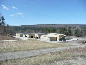
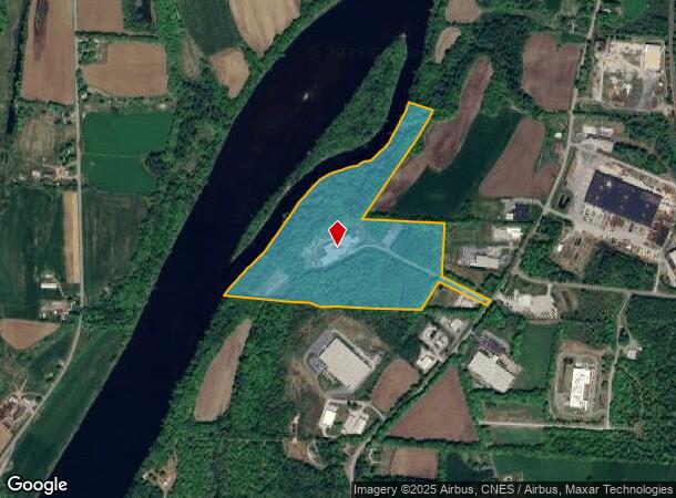
Property Record
78 Balcom Pl, Claremont, NH 03743
NEARBY LISTINGS FOR SALE OR LEASE
Property Detail
78 Balcom Pl
Manufacturinglight
Sullivan
X
New Hampshire
50027C0734E
3
2024
53.32 AC
2024
Other Market Areas
975800
Claremont-Lebanon, NH-VT
52,297 SF
CLMN-000174-000000-000003
DEMOGRAPHICS near 78 Balcom Pl
1 Mile
3 Mile
5 Mile
2024 Total Population
107
5,161
17,631
2029 Population
112
5,403
18,523
Pop Growth 2024-2029
+ 4.67%
+ 4.69%
+ 5.06%
Average Age
45
43
43
2024 Total Households
47
2,198
7,542
HH Growth 2024-2029
+ 4.26%
+ 4.32%
+ 4.80%
Median Household Inc
$68,437
$61,328
$49,166
Avg Household Size
2.20
2.30
2.20
2024 Avg HH Vehicles
2.00
2.00
2.00
Median Home Value
$194,117
$171,173
$163,147
Median Year Built
1977
1969
1965
Nearby Places
Map Layers
Map Styles
 Street
 Aerial
- Restaurants
- Banks
- Shops
- Fitness
- Groceries
PUBLIC TRANSPORTATION
COMMUTER RAIL
Claremont Amtrak (Vermonter - Amtrak)
DRIVE
WALK
Distance
Claremont Amtrak (Vermonter - Amtrak)
6 min
2.7 mi
Freight Ports
Albany, NY Port
DRIVE
WALK
Distance
Albany, NY Port
171 min
108.5 mi
Nearby Properties
Address
Land Use
TOTAL SIZE
Lot Size
Zoning
Address
Land Use
TOTAL SIZE
Lot Size
Zoning
246,345 SF
42.53 AC
I2
Address
Land Use
TOTAL SIZE
Lot Size
Zoning
14,980 SF
6.49 AC
R2
Address
Land Use
TOTAL SIZE
Lot Size
Zoning
62,170 SF
13.82 AC
I3
Address
Land Use
TOTAL SIZE
Lot Size
Zoning
35,095 SF
3.03 AC
B2
Address
Land Use
TOTAL SIZE
Lot Size
Zoning
7,868 SF
5.43 AC
B2
Address
Land Use
TOTAL SIZE
Lot Size
Zoning
137,790 SF
25.28 AC
I1
Address
Land Use
TOTAL SIZE
Lot Size
Zoning
72,925 SF
27.69 AC
R2
Address
Land Use
TOTAL SIZE
Lot Size
Zoning
45,723 SF
3.49 AC
R1
Address
Land Use
TOTAL SIZE
Lot Size
Zoning
1,700 SF
130.86 AC
I1
Address
Land Use
TOTAL SIZE
Lot Size
Zoning
95,377 SF
14.65 AC
I3
Address
Land Use
TOTAL SIZE
Lot Size
Zoning
28,444 SF
24.10 AC
B2
Address
Land Use
TOTAL SIZE
Lot Size
Zoning
18,325 SF
13.23 AC
B2
Address
Land Use
TOTAL SIZE
Lot Size
Zoning
86,164 SF
13.20 AC
I1
Address
Land Use
TOTAL SIZE
Lot Size
Zoning
108,564 SF
18.07 AC
I1
Address
Land Use
TOTAL SIZE
Lot Size
Zoning
Address
Land Use
TOTAL SIZE
Lot Size
Zoning
13,417 SF
7 AC
Address
Land Use
TOTAL SIZE
Lot Size
Zoning
114,634 SF
13.40 AC
I2
Address
Land Use
TOTAL SIZE
Lot Size
Zoning
14,102 SF
4.37 AC
B2
Address
Land Use
TOTAL SIZE
Lot Size
Zoning
248,192 SF
29.50 AC
I2
Address
Land Use
TOTAL SIZE
Lot Size
Zoning
2,778 SF
1 AC
Address
Land Use
TOTAL SIZE
Lot Size
Zoning
11.52 AC
Address
Land Use
TOTAL SIZE
Lot Size
Zoning
13,263 SF
12.27 AC
I3
Address
Land Use
TOTAL SIZE
Lot Size
Zoning
5,190 SF
1.91 AC
B2
Address
Land Use
TOTAL SIZE
Lot Size
Zoning
1.54 AC
R1
Address
Land Use
TOTAL SIZE
Lot Size
Zoning
30,494 SF
3.43 AC
B2
Address
Land Use
TOTAL SIZE
Lot Size
Zoning
2,872 SF
1.33 AC
R2
Address
Land Use
TOTAL SIZE
Lot Size
Zoning
26,524 SF
5.15 AC
I1
Address
Land Use
TOTAL SIZE
Lot Size
Zoning
680 SF
4.20 AC
I2
Address
Land Use
TOTAL SIZE
Lot Size
Zoning
33,340 SF
4.80 AC
I1
The World's #1 Commercial Real Estate Marketplace
Connect with us
© 2025 CoStar Group
The information above has been obtained from sources believed reliable. While we do not doubt its accuracy we have not verified it and make no guarantee, warranty or representation about it. It is your responsibility to independently confirm its accuracy and completeness. Any projections, opinions, assumptions, or estimates used are for example only and do not represent the current or future performance of the property. The value of this transaction to you depends on tax and other factors which should be evaluated by your tax, financial, and legal advisors. You and your advisors should conduct a careful, independent investigation of the property to determine to your satisfaction the suitability of the property for your needs.