Property Record
78 Bowen Rd, Bennington, VT 05201
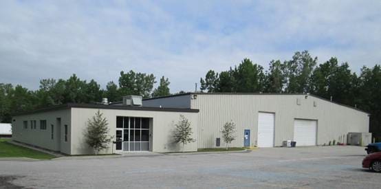

Property Detail
78 Bowen Rd
Bennington, VT
IND BLDG & 16.42A
(015)44-50-69-00
Bennington
Countyproperty
Vermont
AE The base floodplain where base flood elevations are provided. AE Zones are now used on new format FIRMs instead of A1-A30 Zones.
16.42 AC
0
Vermont South Area
2024
Other Market Areas
971200
NEARBY LISTINGS FOR SALE OR LEASE
-
-
View all Bennington listings for sale on LoopNet.com
DEMOGRAPHICS near 78 Bowen Rd
1 mile
3 mile
5 mile
2025 Total Population
4,591
13,342
17,405
2030 Population
4,551
13,187
17,146
Pop Growth 2025-2030
(0.87%)
(1.16%)
(1.49%)
Average Age
42
43
43
2025 Total Households
1,980
5,608
7,133
HH Growth 2025-2030
(0.81%)
(1.12%)
(1.47%)
Median Household Inc
$47,264
$58,999
$61,195
Avg Household Size
2.10
2.20
2.20
2025 Avg HH Vehicles
1.00
2.00
2.00
Median Home Value
$183,813
$224,713
$240,527
Median Year Built
1948
1960
1960
Nearby Places
Map Layers
Map Styles
 Street
 Aerial
Layers
 Traffic
 Biking
Places
Listings with unknown addresses are not visible on the map
- Restaurants
- Banks
- Shops
- Fitness
- Groceries
PUBLIC TRANSPORTATION
AIRPORT
Albany International
Drive
Walk
Distance
Albany International
61 min
38.6 mi
SALE & LEASE HISTORY
LISTING DATE
SALE/LEASE

Sep 26, 2016
For Lease
Sep 24, 2016
For Sale
Oct 10, 2016
For Sale
Nearby Properties
Address
Land Use
TOTAL SIZE
Lot Size
Zoning
Address
Land Use
TOTAL SIZE
Lot Size
Zoning
Address
Land Use
TOTAL SIZE
Lot Size
Zoning
85.76 AC
Address
Land Use
TOTAL SIZE
Lot Size
Zoning
Address
Land Use
TOTAL SIZE
Lot Size
Zoning
82.13 AC
Address
Land Use
TOTAL SIZE
Lot Size
Zoning
44.11 AC
Address
Land Use
TOTAL SIZE
Lot Size
Zoning
150,299 SF
109.97 AC
Address
Land Use
TOTAL SIZE
Lot Size
Zoning
84.32 AC
Address
Land Use
TOTAL SIZE
Lot Size
Zoning
Address
Land Use
TOTAL SIZE
Lot Size
Zoning
88,669 SF
11.47 AC
Address
Land Use
TOTAL SIZE
Lot Size
Zoning
11,373 SF
9 AC
Address
Land Use
TOTAL SIZE
Lot Size
Zoning
10.60 AC
Address
Land Use
TOTAL SIZE
Lot Size
Zoning
112,334 SF
10.92 AC
Address
Land Use
TOTAL SIZE
Lot Size
Zoning
19.20 AC
Address
Land Use
TOTAL SIZE
Lot Size
Zoning
66,622 SF
6.20 AC
Address
Land Use
TOTAL SIZE
Lot Size
Zoning
67,249 SF
Address
Land Use
TOTAL SIZE
Lot Size
Zoning
Address
Land Use
TOTAL SIZE
Lot Size
Zoning
48,821 SF
5.75 AC
Address
Land Use
TOTAL SIZE
Lot Size
Zoning
51,856 SF
7.22 AC
Address
Land Use
TOTAL SIZE
Lot Size
Zoning
6.40 AC
Address
Land Use
TOTAL SIZE
Lot Size
Zoning
24,012 SF
9.44 AC
Address
Land Use
TOTAL SIZE
Lot Size
Zoning
6.17 AC
Address
Land Use
TOTAL SIZE
Lot Size
Zoning
49,358 SF
2.52 AC
Address
Land Use
TOTAL SIZE
Lot Size
Zoning
69,636 SF
6.60 AC
Address
Land Use
TOTAL SIZE
Lot Size
Zoning
4.55 AC
Address
Land Use
TOTAL SIZE
Lot Size
Zoning
31,433 SF
7.51 AC
Address
Land Use
TOTAL SIZE
Lot Size
Zoning
17.13 AC
Address
Land Use
TOTAL SIZE
Lot Size
Zoning
1.43 AC
Address
Land Use
TOTAL SIZE
Lot Size
Zoning
37,857 SF
1.66 AC
Address
Land Use
TOTAL SIZE
Lot Size
Zoning
15.92 AC
Address
Land Use
TOTAL SIZE
Lot Size
Zoning
14,712 SF
1.71 AC
The World's #1 Commercial Real Estate Marketplace
Connect with us
© 2026 CoStar Group
The information above has been obtained from sources believed reliable. While we do not doubt its accuracy we have not verified it and make no guarantee, warranty or representation about it. It is your responsibility to independently confirm its accuracy and completeness. Any projections, opinions, assumptions, or estimates used are for example only and do not represent the current or future performance of the property. The value of this transaction to you depends on tax and other factors which should be evaluated by your tax, financial, and legal advisors. You and your advisors should conduct a careful, independent investigation of the property to determine to your satisfaction the suitability of the property for your needs.