Property Record
78 Cherry St, Park Forest, IL 60466
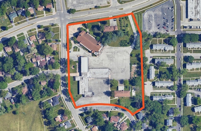

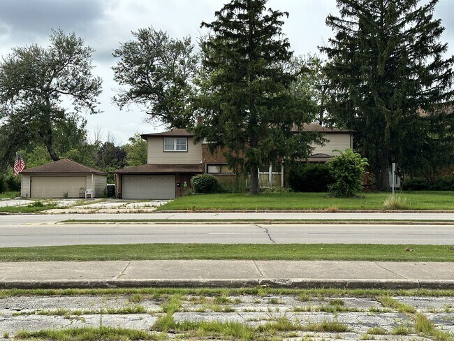
Property Detail
78 Cherry St
31-36-200-008-0000
COOK
Taxexempt
Illinois
B and X Area of moderate flood hazard, usually the area between the limits of the 100-year and 500-year floods.
6 AC
0
Far South
2025
Chicago
830300
Chicago-Naperville-Elgin, IL-IN
NEARBY LISTINGS FOR SALE OR LEASE
DEMOGRAPHICS near 78 Cherry St
1 mile
3 mile
5 mile
2025 Total Population
13,675
80,077
142,634
2030 Population
13,941
81,991
145,708
Pop Growth 2025-2030
+ 1.95%
+ 2.39%
+ 2.16%
Average Age
41
40
41
2025 Total Households
5,921
30,367
52,957
HH Growth 2025-2030
+ 1.49%
+ 2.11%
+ 1.95%
Median Household Inc
$59,534
$61,567
$71,689
Avg Household Size
2.20
2.50
2.60
2025 Avg HH Vehicles
1.00
2.00
2.00
Median Home Value
$87,216
$146,385
$183,095
Median Year Built
1956
1966
1969
Nearby Places
Map Layers
Map Styles
 Street
 Aerial
Layers
 Traffic
 Biking
Places
Listings with unknown addresses are not visible on the map
- Restaurants
- Banks
- Shops
- Fitness
- Groceries
PUBLIC TRANSPORTATION
COMMUTER RAIL
Richton Park Station (Metra Electric Line - Northeast Illinois Regional Commuter Railroad (Metra))
Drive
Walk
Distance
Richton Park Station (Metra Electric Line - Northeast Illinois Regional Commuter Railroad (Metra))
6 min
2.3 mi
Matteson Station (Metra Electric Line - Northeast Illinois Regional Commuter Railroad (Metra))
Drive
Walk
Distance
Matteson Station (Metra Electric Line - Northeast Illinois Regional Commuter Railroad (Metra))
6 min
2.6 mi
AIRPORT
Chicago Midway International
Drive
Walk
Distance
Chicago Midway International
43 min
24.9 mi
Freight Ports
Port Milwaukee
Drive
Walk
Distance
Port Milwaukee
150 min
119.9 mi
Nearby Properties
Address
Land Use
TOTAL SIZE
Lot Size
Zoning
Address
Land Use
TOTAL SIZE
Lot Size
Zoning
192,701 SF
31.69 AC
Address
Land Use
TOTAL SIZE
Lot Size
Zoning
37.62 AC
Address
Land Use
TOTAL SIZE
Lot Size
Zoning
Address
Land Use
TOTAL SIZE
Lot Size
Zoning
471,716 SF
29.58 AC
Address
Land Use
TOTAL SIZE
Lot Size
Zoning
72,668 SF
3 AC
Address
Land Use
TOTAL SIZE
Lot Size
Zoning
70.02 AC
Address
Land Use
TOTAL SIZE
Lot Size
Zoning
300,399 SF
26.50 AC
Address
Land Use
TOTAL SIZE
Lot Size
Zoning
11.84 AC
Address
Land Use
TOTAL SIZE
Lot Size
Zoning
15.23 AC
Address
Land Use
TOTAL SIZE
Lot Size
Zoning
Address
Land Use
TOTAL SIZE
Lot Size
Zoning
183,041 SF
18.71 AC
Address
Land Use
TOTAL SIZE
Lot Size
Zoning
90,908 SF
1.78 AC
Address
Land Use
TOTAL SIZE
Lot Size
Zoning
268,051 SF
40.82 AC
Address
Land Use
TOTAL SIZE
Lot Size
Zoning
628 SF
4.91 AC
Address
Land Use
TOTAL SIZE
Lot Size
Zoning
37,522 SF
2.78 AC
Address
Land Use
TOTAL SIZE
Lot Size
Zoning
114,992 SF
8.10 AC
Address
Land Use
TOTAL SIZE
Lot Size
Zoning
Address
Land Use
TOTAL SIZE
Lot Size
Zoning
3.93 AC
Address
Land Use
TOTAL SIZE
Lot Size
Zoning
37,309 SF
1.50 AC
Address
Land Use
TOTAL SIZE
Lot Size
Zoning
44,000 SF
1.44 AC
Address
Land Use
TOTAL SIZE
Lot Size
Zoning
6.58 AC
Address
Land Use
TOTAL SIZE
Lot Size
Zoning
49,800 SF
4.42 AC
Address
Land Use
TOTAL SIZE
Lot Size
Zoning
24,508 SF
1.13 AC
Address
Land Use
TOTAL SIZE
Lot Size
Zoning
383,144 SF
19.13 AC
Address
Land Use
TOTAL SIZE
Lot Size
Zoning
Address
Land Use
TOTAL SIZE
Lot Size
Zoning
6,350 SF
1.16 AC
Address
Land Use
TOTAL SIZE
Lot Size
Zoning
Address
Land Use
TOTAL SIZE
Lot Size
Zoning
Address
Land Use
TOTAL SIZE
Lot Size
Zoning
185,893 SF
16.74 AC
Address
Land Use
TOTAL SIZE
Lot Size
Zoning
15.64 AC
The World's #1 Commercial Real Estate Marketplace
Connect with us
© 2026 CoStar Group
The information above has been obtained from sources believed reliable. While we do not doubt its accuracy we have not verified it and make no guarantee, warranty or representation about it. It is your responsibility to independently confirm its accuracy and completeness. Any projections, opinions, assumptions, or estimates used are for example only and do not represent the current or future performance of the property. The value of this transaction to you depends on tax and other factors which should be evaluated by your tax, financial, and legal advisors. You and your advisors should conduct a careful, independent investigation of the property to determine to your satisfaction the suitability of the property for your needs.