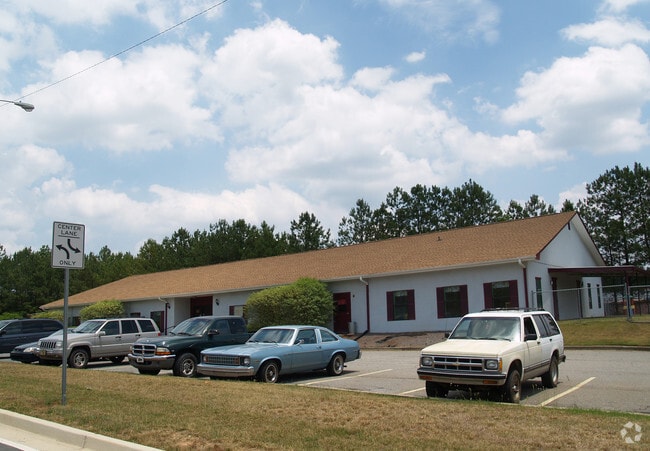
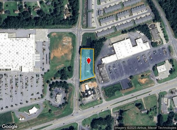
Property Record
78 Citizens Square Rd, Dallas, GA 30157
NEARBY LISTINGS FOR SALE OR LEASE
Property Detail
78 Citizens Square Rd
Atlanta-Sandy Springs-Roswell, GA
Commercial Nh County
110.1.3.002.0000
DIST: 19 SEC: 2 LOT: 145
Daycare
Paulding
X
Georgia
13067C0086G
145
2024
1.13 AC
2024
Paulding Cnty/Dallas
120207
Atlanta
7,840 SF
DEMOGRAPHICS near 78 Citizens Square Rd
1 Mile
3 Mile
5 Mile
2024 Total Population
3,587
36,873
106,923
2029 Population
4,017
39,661
115,041
Pop Growth 2024-2029
+ 11.99%
+ 7.56%
+ 7.59%
Average Age
39
40
39
2024 Total Households
1,219
12,357
36,398
HH Growth 2024-2029
+ 12.14%
+ 7.87%
+ 7.88%
Median Household Inc
$100,149
$118,089
$110,792
Avg Household Size
2.90
2.90
2.90
2024 Avg HH Vehicles
2.00
2.00
2.00
Median Home Value
$276,785
$348,816
$339,178
Median Year Built
1990
1996
1997
Nearby Places
Map Layers
Map Styles
 Street
 Aerial
- Restaurants
- Banks
- Shops
- Fitness
- Groceries
PUBLIC TRANSPORTATION
AIRPORT
Hartsfield - Jackson Atlanta International
DRIVE
WALK
Distance
Hartsfield - Jackson Atlanta International
57 min
38.3 mi
SALE & LEASE HISTORY
LISTING DATE
SALE/LEASE

Sep 25, 2016
For Lease
Sep 24, 2016
For Sale
Oct 31, 2019
For Sale
Oct 14, 2019
For Sale
May 29, 2018
For Sale
May 09, 2019
For Sale
May 04, 2018
For Sale
Aug 22, 2017
For Lease
Nearby Properties
Address
Land Use
TOTAL SIZE
Lot Size
Zoning
Address
Land Use
TOTAL SIZE
Lot Size
Zoning
46.05 AC
Address
Land Use
TOTAL SIZE
Lot Size
Zoning
25.10 AC
Address
Land Use
TOTAL SIZE
Lot Size
Zoning
37.28 AC
Address
Land Use
TOTAL SIZE
Lot Size
Zoning
174,472 SF
60.63 AC
Address
Land Use
TOTAL SIZE
Lot Size
Zoning
223,686 SF
30.20 AC
B2
Address
Land Use
TOTAL SIZE
Lot Size
Zoning
Address
Land Use
TOTAL SIZE
Lot Size
Zoning
Address
Land Use
TOTAL SIZE
Lot Size
Zoning
138,725 SF
11.66 AC
B2
Address
Land Use
TOTAL SIZE
Lot Size
Zoning
151,906 SF
21.07 AC
B2
Address
Land Use
TOTAL SIZE
Lot Size
Zoning
99,972 SF
3.18 AC
NRC/O&I
Address
Land Use
TOTAL SIZE
Lot Size
Zoning
44,972 SF
7.81 AC
B2
Address
Land Use
TOTAL SIZE
Lot Size
Zoning
71,301 SF
3.88 AC
B1
Address
Land Use
TOTAL SIZE
Lot Size
Zoning
74,036 SF
23.20 AC
B2
Address
Land Use
TOTAL SIZE
Lot Size
Zoning
151.43 AC
Address
Land Use
TOTAL SIZE
Lot Size
Zoning
28,886 SF
18 AC
Address
Land Use
TOTAL SIZE
Lot Size
Zoning
77,896 SF
23.36 AC
B2
Address
Land Use
TOTAL SIZE
Lot Size
Zoning
73,040 SF
5.96 AC
B2
Address
Land Use
TOTAL SIZE
Lot Size
Zoning
75,856 SF
10.06 AC
B2
Address
Land Use
TOTAL SIZE
Lot Size
Zoning
52,413 SF
7.57 AC
B2
Address
Land Use
TOTAL SIZE
Lot Size
Zoning
14,314 SF
2.73 AC
Address
Land Use
TOTAL SIZE
Lot Size
Zoning
14,616 SF
2.12 AC
GC
Address
Land Use
TOTAL SIZE
Lot Size
Zoning
16,288 SF
1.96 AC
B2
Address
Land Use
TOTAL SIZE
Lot Size
Zoning
20,324 SF
1.82 AC
B2
Address
Land Use
TOTAL SIZE
Lot Size
Zoning
21,460 SF
2.87 AC
B2
Address
Land Use
TOTAL SIZE
Lot Size
Zoning
12,958 SF
19.27 AC
B2-100
Address
Land Use
TOTAL SIZE
Lot Size
Zoning
9.80 AC
R30
Address
Land Use
TOTAL SIZE
Lot Size
Zoning
62,232 SF
2.02 AC
B2
Address
Land Use
TOTAL SIZE
Lot Size
Zoning
15,035 SF
2.40 AC
CRC
Address
Land Use
TOTAL SIZE
Lot Size
Zoning
1,626 SF
10.11 AC
Address
Land Use
TOTAL SIZE
Lot Size
Zoning
6,713 SF
3.62 AC
GC/WS
The World's #1 Commercial Real Estate Marketplace
Connect with us
© 2025 CoStar Group
The information above has been obtained from sources believed reliable. While we do not doubt its accuracy we have not verified it and make no guarantee, warranty or representation about it. It is your responsibility to independently confirm its accuracy and completeness. Any projections, opinions, assumptions, or estimates used are for example only and do not represent the current or future performance of the property. The value of this transaction to you depends on tax and other factors which should be evaluated by your tax, financial, and legal advisors. You and your advisors should conduct a careful, independent investigation of the property to determine to your satisfaction the suitability of the property for your needs.