Property Record
78 E No Address Assigned By City, Independence, MO 64056

NEARBY LISTINGS FOR SALE OR LEASE
-
-
View all Independence listings for sale on LoopNet.com
Property Detail
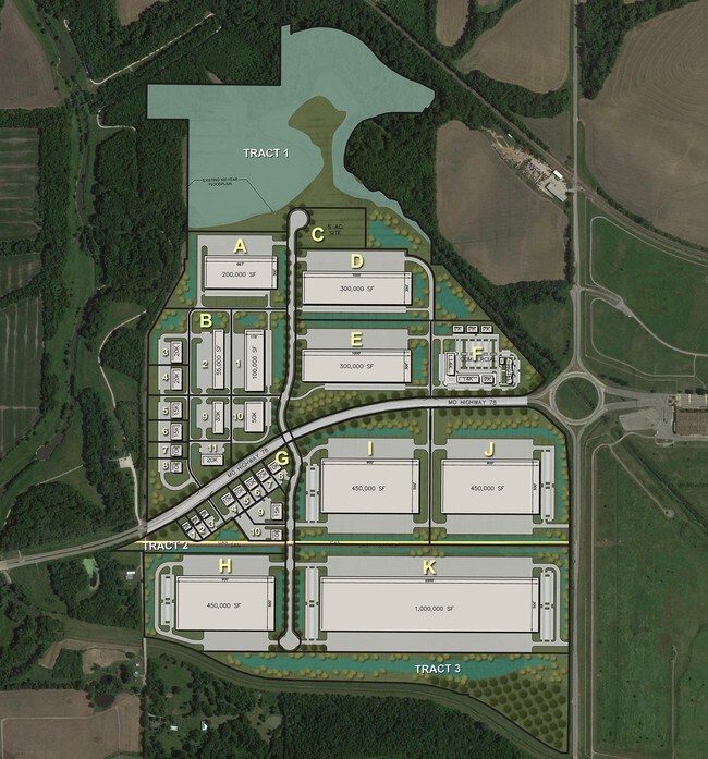
78 E No Address Assigned By City
17-800-01-10-00-0-00-000
SEC 35 TWP 50 RNG 31 E 965 OF TH NE NE 1/4
Agriculturalland
Jackson
A
Missouri
29095C0306G
29.50 AC
2024
East Jackson County
2025
Kansas City
011406
Kansas City, MO-KS
DEMOGRAPHICS near 78 E No Address Assigned By City
1 Mile
3 Mile
5 Mile
2024 Total Population
85
3,382
43,130
2029 Population
82
3,337
42,466
Pop Growth 2024-2029
(3.53%)
(1.33%)
(1.54%)
Average Age
47
40
39
2024 Total Households
30
1,193
15,705
HH Growth 2024-2029
(3.33%)
(1.51%)
(1.69%)
Median Household Inc
$104,687
$88,910
$76,382
Avg Household Size
2.80
2.80
2.70
2024 Avg HH Vehicles
3.00
2.00
2.00
Median Home Value
$266,666
$245,735
$219,191
Median Year Built
1964
1992
1980
Nearby Places
Map Layers
Map Styles
 Street
 Aerial
- Restaurants
- Banks
- Shops
- Fitness
- Groceries
PUBLIC TRANSPORTATION
COMMUTER RAIL
Independence Amtrak Station (Lincoln Service Missouri River Runner - Amtrak, Missouri River Runner - Amtrak)
DRIVE
WALK
Distance
Independence Amtrak Station (Lincoln Service Missouri River Runner - Amtrak, Missouri River Runner - Amtrak)
15 min
8.9 mi
AIRPORT
Kansas City International
DRIVE
WALK
Distance
Kansas City International
51 min
35.4 mi
Freight Ports
Tulsa Port Of Catoosa
DRIVE
WALK
Distance
Tulsa Port Of Catoosa
284 min
254.7 mi
SALE & LEASE HISTORY
LISTING DATE
SALE/LEASE

Jul 08, 2019
For Sale
Aug 28, 2017
For Sale
Nearby Properties
Address
Land Use
TOTAL SIZE
Lot Size
Zoning
Address
Land Use
TOTAL SIZE
Lot Size
Zoning
150,684 SF
55.92 AC
Address
Land Use
TOTAL SIZE
Lot Size
Zoning
60,949 SF
16.90 AC
Address
Land Use
TOTAL SIZE
Lot Size
Zoning
87,793 SF
24.40 AC
Address
Land Use
TOTAL SIZE
Lot Size
Zoning
24,225 SF
Address
Land Use
TOTAL SIZE
Lot Size
Zoning
238,345 SF
24.70 AC
Address
Land Use
TOTAL SIZE
Lot Size
Zoning
136,195 SF
33.50 AC
Address
Land Use
TOTAL SIZE
Lot Size
Zoning
78,528 SF
637 AC
Address
Land Use
TOTAL SIZE
Lot Size
Zoning
1,160,701 SF
520 AC
Address
Land Use
TOTAL SIZE
Lot Size
Zoning
152,806 SF
94.25 AC
Address
Land Use
TOTAL SIZE
Lot Size
Zoning
48,700 SF
37.44 AC
Address
Land Use
TOTAL SIZE
Lot Size
Zoning
60,046 SF
31.82 AC
Address
Land Use
TOTAL SIZE
Lot Size
Zoning
111,555 SF
5.54 AC
Address
Land Use
TOTAL SIZE
Lot Size
Zoning
60,505 SF
128.04 AC
Address
Land Use
TOTAL SIZE
Lot Size
Zoning
61,770 SF
19.98 AC
Address
Land Use
TOTAL SIZE
Lot Size
Zoning
38,783 SF
9.20 AC
Address
Land Use
TOTAL SIZE
Lot Size
Zoning
154,516 SF
230 AC
Address
Land Use
TOTAL SIZE
Lot Size
Zoning
30,396 SF
17.70 AC
Address
Land Use
TOTAL SIZE
Lot Size
Zoning
124,702 SF
540 AC
Address
Land Use
TOTAL SIZE
Lot Size
Zoning
11,219 SF
64.14 AC
Address
Land Use
TOTAL SIZE
Lot Size
Zoning
11,701 SF
95 AC
Address
Land Use
TOTAL SIZE
Lot Size
Zoning
11,760 SF
75.22 AC
Address
Land Use
TOTAL SIZE
Lot Size
Zoning
37.50 AC
Address
Land Use
TOTAL SIZE
Lot Size
Zoning
71,100 SF
4.32 AC
Address
Land Use
TOTAL SIZE
Lot Size
Zoning
11,500 SF
1.46 AC
Address
Land Use
TOTAL SIZE
Lot Size
Zoning
52,080 SF
6.89 AC
Address
Land Use
TOTAL SIZE
Lot Size
Zoning
64,197 SF
2.13 AC
Address
Land Use
TOTAL SIZE
Lot Size
Zoning
Address
Land Use
TOTAL SIZE
Lot Size
Zoning
15,264 SF
5 AC
Address
Land Use
TOTAL SIZE
Lot Size
Zoning
11,802 SF
10 AC
Address
Land Use
TOTAL SIZE
Lot Size
Zoning
17,644 SF
5 AC
The World's #1 Commercial Real Estate Marketplace
Connect with us
© 2025 CoStar Group
The information above has been obtained from sources believed reliable. While we do not doubt its accuracy we have not verified it and make no guarantee, warranty or representation about it. It is your responsibility to independently confirm its accuracy and completeness. Any projections, opinions, assumptions, or estimates used are for example only and do not represent the current or future performance of the property. The value of this transaction to you depends on tax and other factors which should be evaluated by your tax, financial, and legal advisors. You and your advisors should conduct a careful, independent investigation of the property to determine to your satisfaction the suitability of the property for your needs.