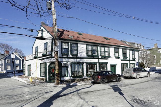
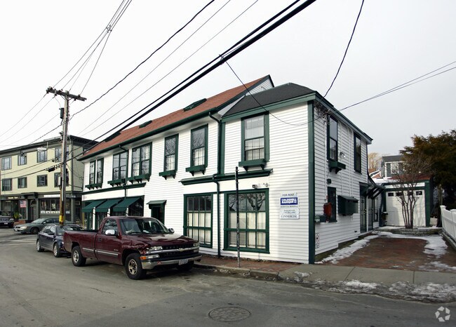
Property Record
78 Front St, Marblehead, MA 01945
Property Detail
78 Front St
Officecondo
Essex
B1
Massachusetts
AE The base floodplain where base flood elevations are provided. AE Zones are now used on new format FIRMs instead of A1-A30 Zones.
3
2025
Peabody/Salem
2025
Boston
203302
Boston-Cambridge-Newton, MA-NH
1,351 SF
MARB-000148-000042-000001
NEARBY LISTINGS FOR SALE OR LEASE
DEMOGRAPHICS near 78 Front St
1 mile
3 mile
5 mile
2024 Total Population
10,117
48,508
146,889
2029 Population
10,479
49,552
149,868
Pop Growth 2024-2029
+ 3.58%
+ 2.15%
+ 2.03%
Average Age
47
42
41
2024 Total Households
4,629
20,388
59,812
HH Growth 2024-2029
+ 3.41%
+ 2.00%
+ 1.98%
Median Household Inc
$134,800
$115,149
$96,990
Avg Household Size
2.20
2.20
2.30
2024 Avg HH Vehicles
2.00
2.00
2.00
Median Home Value
$970,986
$773,395
$693,980
Median Year Built
1948
1947
1949
Nearby Places
Map Layers
Map Styles
 Street
 Aerial
Transit
 Traffic
 Biking
Places
Listings with unknown addresses are not visible on the map
- Restaurants
- Banks
- Shops
- Fitness
- Groceries
PUBLIC TRANSPORTATION
COMMUTER RAIL
Salem (Newburyport/Rockport Line - Massachusetts Bay Transportation Authority Commuter Rail (Purple Line))
Drive
Walk
Distance
Salem (Newburyport/Rockport Line - Massachusetts Bay Transportation Authority Commuter Rail (Purple Line))
11 min
4.9 mi
Swampscott (Newburyport/Rockport Line - Massachusetts Bay Transportation Authority Commuter Rail (Purple Line))
Drive
Walk
Distance
Swampscott (Newburyport/Rockport Line - Massachusetts Bay Transportation Authority Commuter Rail (Purple Line))
10 min
5.2 mi
AIRPORT
General Edward Lawrence Logan International
Drive
Walk
Distance
General Edward Lawrence Logan International
27 min
15.6 mi
Freight Ports
Port of Boston
Drive
Walk
Distance
Port of Boston
33 min
18.3 mi
SALE & LEASE HISTORY
LISTING DATE
SALE/LEASE

Jan 03, 2018
For Sale
Nearby Properties
Address
Land Use
TOTAL SIZE
Lot Size
Zoning
Address
Land Use
TOTAL SIZE
Lot Size
Zoning
14.69 AC
I
Address
Land Use
TOTAL SIZE
Lot Size
Zoning
192,341 SF
2.10 AC
B5
Address
Land Use
TOTAL SIZE
Lot Size
Zoning
29.12 AC
I
Address
Land Use
TOTAL SIZE
Lot Size
Zoning
205,353 SF
18.74 AC
Address
Land Use
TOTAL SIZE
Lot Size
Zoning
14.50 AC
R1
Address
Land Use
TOTAL SIZE
Lot Size
Zoning
123,588 SF
1.50 AC
B5
Address
Land Use
TOTAL SIZE
Lot Size
Zoning
125,862 SF
5.30 AC
R1
Address
Land Use
TOTAL SIZE
Lot Size
Zoning
40,939 SF
12.48 AC
Address
Land Use
TOTAL SIZE
Lot Size
Zoning
22.35 AC
R1
Address
Land Use
TOTAL SIZE
Lot Size
Zoning
42.30 AC
I
Address
Land Use
TOTAL SIZE
Lot Size
Zoning
31.90 AC
I
Address
Land Use
TOTAL SIZE
Lot Size
Zoning
91,968 SF
2.20 AC
R1
Address
Land Use
TOTAL SIZE
Lot Size
Zoning
123,936 SF
2.50 AC
B5
Address
Land Use
TOTAL SIZE
Lot Size
Zoning
595 SF
36.94 AC
SR
Address
Land Use
TOTAL SIZE
Lot Size
Zoning
52,898 SF
1.84 AC
R2
Address
Land Use
TOTAL SIZE
Lot Size
Zoning
140,453 SF
18.20 AC
SR
Address
Land Use
TOTAL SIZE
Lot Size
Zoning
86,449 SF
0.52 AC
Address
Land Use
TOTAL SIZE
Lot Size
Zoning
1.04 AC
B5
Address
Land Use
TOTAL SIZE
Lot Size
Zoning
84,173 SF
4.50 AC
SR
Address
Land Use
TOTAL SIZE
Lot Size
Zoning
26,582 SF
5.03 AC
LSR
Address
Land Use
TOTAL SIZE
Lot Size
Zoning
83,220 SF
2.60 AC
R2
Address
Land Use
TOTAL SIZE
Lot Size
Zoning
3.52 AC
I
Address
Land Use
TOTAL SIZE
Lot Size
Zoning
145,500 SF
6.10 AC
I
Address
Land Use
TOTAL SIZE
Lot Size
Zoning
5.74 AC
SR
Address
Land Use
TOTAL SIZE
Lot Size
Zoning
3.74 AC
LSR
Address
Land Use
TOTAL SIZE
Lot Size
Zoning
11.48 AC
Address
Land Use
TOTAL SIZE
Lot Size
Zoning
90,696 SF
15.45 AC
R1
Address
Land Use
TOTAL SIZE
Lot Size
Zoning
33,264 SF
30.60 AC
SR
Address
Land Use
TOTAL SIZE
Lot Size
Zoning
47,476 SF
4.22 AC
B1
Address
Land Use
TOTAL SIZE
Lot Size
Zoning
68,466 SF
10.07 AC
The World's #1 Commercial Real Estate Marketplace
Connect with us
© 2026 CoStar Group
The information above has been obtained from sources believed reliable. While we do not doubt its accuracy we have not verified it and make no guarantee, warranty or representation about it. It is your responsibility to independently confirm its accuracy and completeness. Any projections, opinions, assumptions, or estimates used are for example only and do not represent the current or future performance of the property. The value of this transaction to you depends on tax and other factors which should be evaluated by your tax, financial, and legal advisors. You and your advisors should conduct a careful, independent investigation of the property to determine to your satisfaction the suitability of the property for your needs.