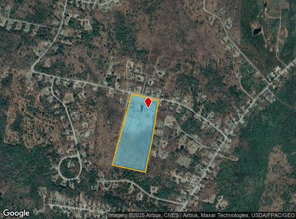
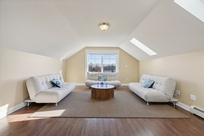
Property Record
98 Hussey Hill Rd, Oakland, ME 04963
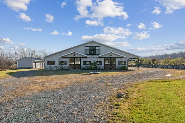
This Property Is For Sale
NEARBY LISTINGS FOR SALE OR LEASE
Property Detail
98 Hussey Hill Rd
Augusta-Waterville, ME
Kennebec
OAKL-000026-000000-000022
Maine
Sfr
18.41 AC
X
Maine South & Augusta
23011C0155D
Other Market Areas
3,116 SF
DEMOGRAPHICS near 98 Hussey Hill Rd
1 Mile
3 Mile
5 Mile
2024 Total Population
1,000
6,861
25,957
2029 Population
1,062
7,201
26,802
Pop Growth 2024-2029
+ 6.20%
+ 4.96%
+ 3.26%
Average Age
43
42
42
2024 Total Households
418
2,760
11,052
HH Growth 2024-2029
+ 6.22%
+ 5.18%
+ 3.29%
Median Household Inc
$102,639
$79,756
$56,715
Avg Household Size
2.40
2.30
2.10
2024 Avg HH Vehicles
2.00
2.00
2.00
Median Home Value
$176,990
$196,481
$172,105
Median Year Built
1987
1989
1971
Nearby Places
- Restaurants
- Banks
- Shops
- Fitness
- Groceries
Nearby Properties
Address
Land Use
TOTAL SIZE
Lot Size
Zoning
Address
Land Use
TOTAL SIZE
Lot Size
Zoning
DOWNTO
Address
Land Use
TOTAL SIZE
Lot Size
Zoning
2,388 SF
63.68 AC
SUBURB
Address
Land Use
TOTAL SIZE
Lot Size
Zoning
26.20 AC
HIGHWA
Address
Land Use
TOTAL SIZE
Lot Size
Zoning
92,224 SF
16.68 AC
Address
Land Use
TOTAL SIZE
Lot Size
Zoning
Address
Land Use
TOTAL SIZE
Lot Size
Zoning
5.41 AC
DOWNTO
Address
Land Use
TOTAL SIZE
Lot Size
Zoning
20,410 SF
6.80 AC
HIGHWA
Address
Land Use
TOTAL SIZE
Lot Size
Zoning
35,000 SF
4.58 AC
HIGHWA
Address
Land Use
TOTAL SIZE
Lot Size
Zoning
46,578 SF
3.68 AC
Address
Land Use
TOTAL SIZE
Lot Size
Zoning
96.67 AC
SHOREL
Address
Land Use
TOTAL SIZE
Lot Size
Zoning
52,927 SF
9.20 AC
DOWNTO
Address
Land Use
TOTAL SIZE
Lot Size
Zoning
Address
Land Use
TOTAL SIZE
Lot Size
Zoning
25 AC
NEIGHB
Address
Land Use
TOTAL SIZE
Lot Size
Zoning
17,689 SF
2.57 AC
HIGHWA
Address
Land Use
TOTAL SIZE
Lot Size
Zoning
Address
Land Use
TOTAL SIZE
Lot Size
Zoning
6.67 AC
SUBURB
Address
Land Use
TOTAL SIZE
Lot Size
Zoning
INDUST
Address
Land Use
TOTAL SIZE
Lot Size
Zoning
RURAL.
Address
Land Use
TOTAL SIZE
Lot Size
Zoning
19,144 SF
3.31 AC
Address
Land Use
TOTAL SIZE
Lot Size
Zoning
SHOREL
Address
Land Use
TOTAL SIZE
Lot Size
Zoning
2,592 SF
34.90 AC
SHOREL
Address
Land Use
TOTAL SIZE
Lot Size
Zoning
11,326 SF
3.78 AC
HIGHWA
Address
Land Use
TOTAL SIZE
Lot Size
Zoning
118 AC
RURAL.
Address
Land Use
TOTAL SIZE
Lot Size
Zoning
22,560 SF
4.02 AC
Address
Land Use
TOTAL SIZE
Lot Size
Zoning
3.42 AC
SUBURB
Address
Land Use
TOTAL SIZE
Lot Size
Zoning
53,733 SF
5.24 AC
HIGHWA
Address
Land Use
TOTAL SIZE
Lot Size
Zoning
10.85 AC
NEIGHB
Address
Land Use
TOTAL SIZE
Lot Size
Zoning
105 SF
0.26 AC
DOWNTO
Address
Land Use
TOTAL SIZE
Lot Size
Zoning
980 SF
10 AC
NEIGHB
Address
Land Use
TOTAL SIZE
Lot Size
Zoning
15,680 SF
0.97 AC
DOWNTO
The World's #1 Commercial Real Estate Marketplace
Connect with us
© 2025 CoStar Group
The information above has been obtained from sources believed reliable. While we do not doubt its accuracy we have not verified it and make no guarantee, warranty or representation about it. It is your responsibility to independently confirm its accuracy and completeness. Any projections, opinions, assumptions, or estimates used are for example only and do not represent the current or future performance of the property. The value of this transaction to you depends on tax and other factors which should be evaluated by your tax, financial, and legal advisors. You and your advisors should conduct a careful, independent investigation of the property to determine to your satisfaction the suitability of the property for your needs.