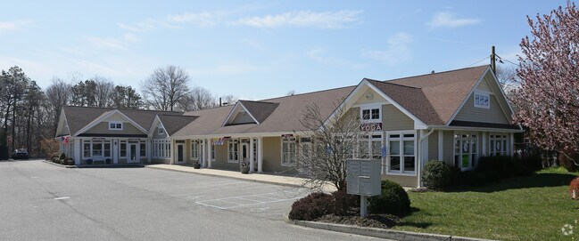
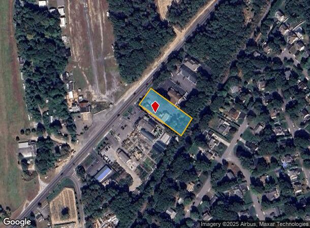
Property Record
78 Montauk Hwy, East Moriches, NY 11940

NEARBY LISTINGS FOR SALE OR LEASE
Property Detail
78 Montauk Hwy
Nassau County-Suffolk County, NY
Newport Beach
0200-722-00-01-00-016-000
NEWPORT BEACH 3033 23 TO 25
Commercialnec
Suffolk
X
New York
36103C0753H
16
2024
0.84 AC
2024
Eastern Suffolk
159406
Long Island (New York)
DEMOGRAPHICS near 78 Montauk Hwy
1 Mile
3 Mile
5 Mile
2024 Total Population
3,039
20,802
45,437
2029 Population
3,017
20,542
45,524
Pop Growth 2024-2029
(0.72%)
(1.25%)
+ 0.19%
Average Age
43
43
43
2024 Total Households
1,052
7,304
16,414
HH Growth 2024-2029
(0.86%)
(1.44%)
+ 0.10%
Median Household Inc
$119,317
$117,717
$112,706
Avg Household Size
2.80
2.70
2.70
2024 Avg HH Vehicles
2.00
2.00
2.00
Median Home Value
$593,830
$617,311
$592,860
Median Year Built
1977
1985
1986
Nearby Places
- Restaurants
- Banks
- Shops
- Fitness
- Groceries
PUBLIC TRANSPORTATION
COMMUTER RAIL
Speonk Station (Montauk Branch - Long Island Rail Road)
DRIVE
WALK
Distance
Speonk Station (Montauk Branch - Long Island Rail Road)
4 min
2.7 mi
Westhampton Station (Montauk Branch - Long Island Rail Road)
DRIVE
WALK
Distance
Westhampton Station (Montauk Branch - Long Island Rail Road)
11 min
6.6 mi
AIRPORT
Long Island MacArthur
DRIVE
WALK
Distance
Long Island MacArthur
34 min
21.3 mi
Freight Ports
Port of New Haven
DRIVE
WALK
Distance
Port of New Haven
149 min
61.1 mi
SALE & LEASE HISTORY
LISTING DATE
SALE/LEASE

Sep 25, 2016
For Lease
Sep 23, 2016
For Sale
Oct 23, 2019
For Lease
Feb 07, 2017
For Lease
Nearby Properties
Address
Land Use
TOTAL SIZE
Lot Size
Zoning
Address
Land Use
TOTAL SIZE
Lot Size
Zoning
200 SF
67.80 AC
CR200
Address
Land Use
TOTAL SIZE
Lot Size
Zoning
15,084 SF
10.25 AC
R40
Address
Land Use
TOTAL SIZE
Lot Size
Zoning
87,569 SF
19 AC
R120
Address
Land Use
TOTAL SIZE
Lot Size
Zoning
30,512 SF
4.28 AC
VB
Address
Land Use
TOTAL SIZE
Lot Size
Zoning
16,854 SF
11.95 AC
OD
Address
Land Use
TOTAL SIZE
Lot Size
Zoning
8,636 SF
1.55 AC
R40
Address
Land Use
TOTAL SIZE
Lot Size
Zoning
9,069 SF
4.19 AC
R60
Address
Land Use
TOTAL SIZE
Lot Size
Zoning
7.40 AC
R40
Address
Land Use
TOTAL SIZE
Lot Size
Zoning
90.50 AC
CR200
Address
Land Use
TOTAL SIZE
Lot Size
Zoning
8,098 SF
3 AC
R40
Address
Land Use
TOTAL SIZE
Lot Size
Zoning
6,975 SF
0.92 AC
R40
Address
Land Use
TOTAL SIZE
Lot Size
Zoning
40,190 SF
4.89 AC
LI40
Address
Land Use
TOTAL SIZE
Lot Size
Zoning
1,984 SF
6.19 AC
R60
Address
Land Use
TOTAL SIZE
Lot Size
Zoning
5,897 SF
1.48 AC
R40
Address
Land Use
TOTAL SIZE
Lot Size
Zoning
16,654 SF
1.64 AC
R40
Address
Land Use
TOTAL SIZE
Lot Size
Zoning
607,016 SF
8.41 AC
LI40
Address
Land Use
TOTAL SIZE
Lot Size
Zoning
8,282 SF
4.41 AC
R40
Address
Land Use
TOTAL SIZE
Lot Size
Zoning
150 SF
4.70 AC
RWB
Address
Land Use
TOTAL SIZE
Lot Size
Zoning
36.77 AC
CR60
Address
Land Use
TOTAL SIZE
Lot Size
Zoning
26,488 SF
2.90 AC
LI40
Address
Land Use
TOTAL SIZE
Lot Size
Zoning
1.60 AC
R60
Address
Land Use
TOTAL SIZE
Lot Size
Zoning
9,256 SF
0.90 AC
R40
Address
Land Use
TOTAL SIZE
Lot Size
Zoning
1.30 AC
R60
Address
Land Use
TOTAL SIZE
Lot Size
Zoning
3,273 SF
1.10 AC
R20
Address
Land Use
TOTAL SIZE
Lot Size
Zoning
4,648 SF
0.92 AC
R40
Address
Land Use
TOTAL SIZE
Lot Size
Zoning
12,000 SF
1.63 AC
LI40
Address
Land Use
TOTAL SIZE
Lot Size
Zoning
7,122 SF
1.95 AC
R40
Address
Land Use
TOTAL SIZE
Lot Size
Zoning
2.53 AC
R60
Address
Land Use
TOTAL SIZE
Lot Size
Zoning
9,334 SF
1.09 AC
R40
Address
Land Use
TOTAL SIZE
Lot Size
Zoning
7,024 SF
1.16 AC
R40
The World's #1 Commercial Real Estate Marketplace
Connect with us
© 2025 CoStar Group
The information above has been obtained from sources believed reliable. While we do not doubt its accuracy we have not verified it and make no guarantee, warranty or representation about it. It is your responsibility to independently confirm its accuracy and completeness. Any projections, opinions, assumptions, or estimates used are for example only and do not represent the current or future performance of the property. The value of this transaction to you depends on tax and other factors which should be evaluated by your tax, financial, and legal advisors. You and your advisors should conduct a careful, independent investigation of the property to determine to your satisfaction the suitability of the property for your needs.