Property Record
78 Precast Rd, Milton, VT 05468
NEARBY LISTINGS FOR SALE OR LEASE
-
-
View all Milton listings for sale on LoopNet.com
Property Detail
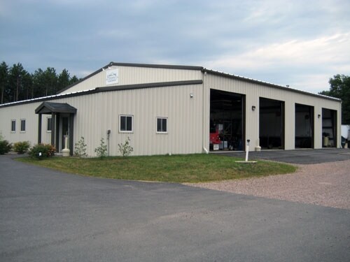
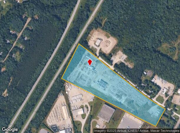
78 Precast Rd
(123) 203020.000000
INDUSTRIAL
Multipleuses
Chittenden
X
Vermont
50007C0131D
18.27 AC
2022
Vermont North Area
2024
Other Market Areas
002104
Burlington-South Burlington, VT
DEMOGRAPHICS near 78 Precast Rd
1 Mile
3 Mile
5 Mile
2024 Total Population
878
7,652
14,792
2029 Population
900
7,774
15,002
Pop Growth 2024-2029
+ 2.51%
+ 1.59%
+ 1.42%
Average Age
41
41
41
2024 Total Households
337
3,124
6,068
HH Growth 2024-2029
+ 2.67%
+ 1.70%
+ 1.53%
Median Household Inc
$109,879
$96,784
$99,868
Avg Household Size
2.60
2.40
2.40
2024 Avg HH Vehicles
2.00
2.00
2.00
Median Home Value
$405,970
$296,147
$318,841
Median Year Built
1982
1983
1984
Nearby Places
Map Layers
Map Styles
 Street
 Aerial
- Restaurants
- Banks
- Shops
- Fitness
- Groceries
PUBLIC TRANSPORTATION
COMMUTER RAIL
Essex Junction-Burlington Amtrak Station (Vermonter - Amtrak)
DRIVE
WALK
Distance
Essex Junction-Burlington Amtrak Station (Vermonter - Amtrak)
18 min
9.8 mi
AIRPORT
Patrick Leahy Burlington International
DRIVE
WALK
Distance
Patrick Leahy Burlington International
25 min
12.3 mi
Plattsburgh International
DRIVE
WALK
Distance
Plattsburgh International
56 min
25.9 mi
Freight Ports
Montreal
DRIVE
WALK
Distance
Montreal
116 min
87.8 mi
Nearby Properties
Address
Land Use
TOTAL SIZE
Lot Size
Zoning
Address
Land Use
TOTAL SIZE
Lot Size
Zoning
20.30 AC
Address
Land Use
TOTAL SIZE
Lot Size
Zoning
133.20 AC
Address
Land Use
TOTAL SIZE
Lot Size
Zoning
120,000 SF
48 AC
Address
Land Use
TOTAL SIZE
Lot Size
Zoning
0.43 AC
Address
Land Use
TOTAL SIZE
Lot Size
Zoning
18.56 AC
Address
Land Use
TOTAL SIZE
Lot Size
Zoning
72,540 SF
12.55 AC
Address
Land Use
TOTAL SIZE
Lot Size
Zoning
126,000 SF
19.59 AC
Address
Land Use
TOTAL SIZE
Lot Size
Zoning
4.93 AC
Address
Land Use
TOTAL SIZE
Lot Size
Zoning
3.80 AC
Address
Land Use
TOTAL SIZE
Lot Size
Zoning
47,852 SF
Address
Land Use
TOTAL SIZE
Lot Size
Zoning
81,894 SF
9.35 AC
Address
Land Use
TOTAL SIZE
Lot Size
Zoning
58,086 SF
24.41 AC
Address
Land Use
TOTAL SIZE
Lot Size
Zoning
33,230 SF
7.82 AC
Address
Land Use
TOTAL SIZE
Lot Size
Zoning
17.18 AC
Address
Land Use
TOTAL SIZE
Lot Size
Zoning
57.64 AC
Address
Land Use
TOTAL SIZE
Lot Size
Zoning
64,800 SF
8.33 AC
Address
Land Use
TOTAL SIZE
Lot Size
Zoning
6.73 AC
Address
Land Use
TOTAL SIZE
Lot Size
Zoning
38,016 SF
1.24 AC
Address
Land Use
TOTAL SIZE
Lot Size
Zoning
17,616 SF
7.10 AC
Address
Land Use
TOTAL SIZE
Lot Size
Zoning
178.40 AC
Address
Land Use
TOTAL SIZE
Lot Size
Zoning
16.65 AC
Address
Land Use
TOTAL SIZE
Lot Size
Zoning
3.09 AC
Address
Land Use
TOTAL SIZE
Lot Size
Zoning
3.12 AC
Address
Land Use
TOTAL SIZE
Lot Size
Zoning
1,596 SF
138.30 AC
Address
Land Use
TOTAL SIZE
Lot Size
Zoning
124.48 AC
Address
Land Use
TOTAL SIZE
Lot Size
Zoning
20,488 SF
6.66 AC
Address
Land Use
TOTAL SIZE
Lot Size
Zoning
5.22 AC
Address
Land Use
TOTAL SIZE
Lot Size
Zoning
180 SF
17.53 AC
Address
Land Use
TOTAL SIZE
Lot Size
Zoning
34,208 SF
8.30 AC
The World's #1 Commercial Real Estate Marketplace
Connect with us
© 2025 CoStar Group
The information above has been obtained from sources believed reliable. While we do not doubt its accuracy we have not verified it and make no guarantee, warranty or representation about it. It is your responsibility to independently confirm its accuracy and completeness. Any projections, opinions, assumptions, or estimates used are for example only and do not represent the current or future performance of the property. The value of this transaction to you depends on tax and other factors which should be evaluated by your tax, financial, and legal advisors. You and your advisors should conduct a careful, independent investigation of the property to determine to your satisfaction the suitability of the property for your needs.