Property Record
78 S Trooper Rd, West Norriton, PA 19403


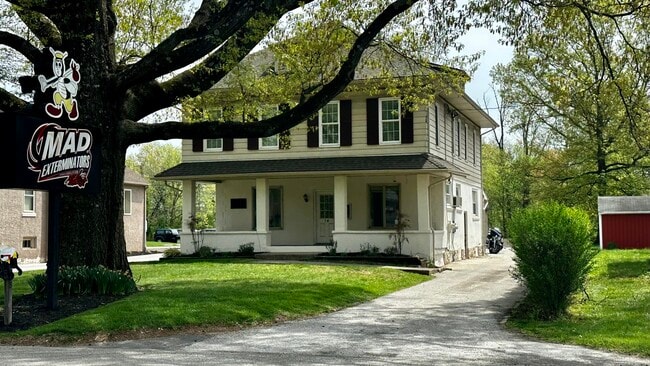
This Property Is For Sale
NEARBY LISTINGS FOR SALE OR LEASE
Property Detail
78 S Trooper Rd
63-00-08422-002
H G & L 55 X 260
Commercialnec
Montgomery
X
Pennsylvania
42091C0245G
7
2024
0.30 AC
2025
Norristown/Valley Forge
203402
Philadelphia
4,128 SF
Philadelphia-Camden-Wilmington, PA-NJ-DE-MD
DEMOGRAPHICS near 78 S Trooper Rd
1 Mile
3 Mile
5 Mile
2024 Total Population
7,217
72,346
163,689
2029 Population
7,338
73,431
166,938
Pop Growth 2024-2029
+ 1.68%
+ 1.50%
+ 1.98%
Average Age
43
41
40
2024 Total Households
2,884
27,928
64,351
HH Growth 2024-2029
+ 1.63%
+ 1.48%
+ 2.10%
Median Household Inc
$105,306
$89,490
$93,293
Avg Household Size
2.40
2.40
2.40
2024 Avg HH Vehicles
2.00
2.00
2.00
Median Home Value
$323,607
$329,456
$343,311
Median Year Built
1972
1971
1972
Nearby Places
Map Layers
Map Styles
 Street
 Aerial
- Restaurants
- Banks
- Shops
- Fitness
- Groceries
PUBLIC TRANSPORTATION
COMMUTER RAIL
Main Street (Norristown) (R6 - Southeastern Pennsylvania Transportation Authority Regional Rail (SEPTA Regional Rail))
DRIVE
WALK
Distance
Main Street (Norristown) (R6 - Southeastern Pennsylvania Transportation Authority Regional Rail (SEPTA Regional Rail))
7 min
3.1 mi
Elm Street (Norristown) (R6 - Southeastern Pennsylvania Transportation Authority Regional Rail (SEPTA Regional Rail))
DRIVE
WALK
Distance
Elm Street (Norristown) (R6 - Southeastern Pennsylvania Transportation Authority Regional Rail (SEPTA Regional Rail))
8 min
3.4 mi
AIRPORT
Philadelphia International
DRIVE
WALK
Distance
Philadelphia International
49 min
31.6 mi
Freight Ports
Port of Philadelphia
DRIVE
WALK
Distance
Port of Philadelphia
44 min
28.8 mi
Nearby Properties
Address
Land Use
TOTAL SIZE
Lot Size
Zoning
Address
Land Use
TOTAL SIZE
Lot Size
Zoning
1,807,465 SF
120.12 AC
R2
Address
Land Use
TOTAL SIZE
Lot Size
Zoning
365,348 SF
80.44 AC
IN
Address
Land Use
TOTAL SIZE
Lot Size
Zoning
124,789 SF
155.99 AC
INO
Address
Land Use
TOTAL SIZE
Lot Size
Zoning
972,935 SF
20.51 AC
INO
Address
Land Use
TOTAL SIZE
Lot Size
Zoning
388,042 SF
24.45 AC
SM
Address
Land Use
TOTAL SIZE
Lot Size
Zoning
617,174 SF
25.32 AC
HR
Address
Land Use
TOTAL SIZE
Lot Size
Zoning
454,933 SF
17.85 AC
SM
Address
Land Use
TOTAL SIZE
Lot Size
Zoning
422,975 SF
92.05 AC
RA
Address
Land Use
TOTAL SIZE
Lot Size
Zoning
502,080 SF
11.36 AC
RA
Address
Land Use
TOTAL SIZE
Lot Size
Zoning
348,190 SF
68 AC
R1
Address
Land Use
TOTAL SIZE
Lot Size
Zoning
503,942 SF
11.26 AC
RA
Address
Land Use
TOTAL SIZE
Lot Size
Zoning
199,873 SF
71.47 AC
INO
Address
Land Use
TOTAL SIZE
Lot Size
Zoning
381,927 SF
5.10 AC
SM
Address
Land Use
TOTAL SIZE
Lot Size
Zoning
396,137 SF
2.26 AC
HR
Address
Land Use
TOTAL SIZE
Lot Size
Zoning
367,115 SF
62.90 AC
AGR
Address
Land Use
TOTAL SIZE
Lot Size
Zoning
435,884 SF
26.70 AC
R5
Address
Land Use
TOTAL SIZE
Lot Size
Zoning
273,724 SF
8.05 AC
INO
Address
Land Use
TOTAL SIZE
Lot Size
Zoning
639,052 SF
45 AC
SM
Address
Land Use
TOTAL SIZE
Lot Size
Zoning
208,680 SF
4.54 AC
LCI
Address
Land Use
TOTAL SIZE
Lot Size
Zoning
311,784 SF
21.82 AC
A
Address
Land Use
TOTAL SIZE
Lot Size
Zoning
211,739 SF
14.14 AC
CR
Address
Land Use
TOTAL SIZE
Lot Size
Zoning
305,760 SF
22.50 AC
R2
Address
Land Use
TOTAL SIZE
Lot Size
Zoning
252,272 SF
18.86 AC
A
Address
Land Use
TOTAL SIZE
Lot Size
Zoning
276,284 SF
3.87 AC
INO
Address
Land Use
TOTAL SIZE
Lot Size
Zoning
212,528 SF
8.02 AC
SM
Address
Land Use
TOTAL SIZE
Lot Size
Zoning
230,132 SF
25.44 AC
SM
Address
Land Use
TOTAL SIZE
Lot Size
Zoning
284,250 SF
17.10 AC
A
Address
Land Use
TOTAL SIZE
Lot Size
Zoning
155,709 SF
3.44 AC
SM
Address
Land Use
TOTAL SIZE
Lot Size
Zoning
234,091 SF
53.94 AC
PBO
Address
Land Use
TOTAL SIZE
Lot Size
Zoning
84,970 SF
19.99 AC
R2A
The World's #1 Commercial Real Estate Marketplace
Connect with us
© 2026 CoStar Group
The information above has been obtained from sources believed reliable. While we do not doubt its accuracy we have not verified it and make no guarantee, warranty or representation about it. It is your responsibility to independently confirm its accuracy and completeness. Any projections, opinions, assumptions, or estimates used are for example only and do not represent the current or future performance of the property. The value of this transaction to you depends on tax and other factors which should be evaluated by your tax, financial, and legal advisors. You and your advisors should conduct a careful, independent investigation of the property to determine to your satisfaction the suitability of the property for your needs.