Property Record
78 Valley Rd, Cos Cob, CT 06807

Save to a Folder
{{folder.Name}}
{{folder.ListingIds.length}} Properties
{{folder.ListingIds.length}} Property
Create a New Folder
Property Detail
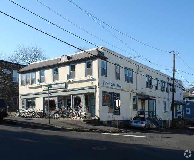
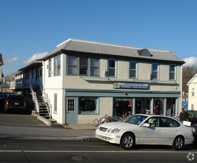
78 Valley Rd
Commercialofficeresidentialmixeduse
Western Ct
LBR-2
Connecticut
B and X Area of moderate flood hazard, usually the area between the limits of the 100-year and 500-year floods.
0.18 AC
2025
Greenwich
2025
Westchester/So Connecticut
010202
Bridgeport-Stamford-Danbury, CT
7,462 SF
GREE-000008-000000-001107-S000000
NEARBY LISTINGS FOR SALE OR LEASE
DEMOGRAPHICS near 78 Valley Rd
1 mile
3 mile
5 mile
2025 Total Population
10,515
89,622
203,023
2030 Population
10,706
92,088
207,002
Pop Growth 2025-2030
+ 1.82%
+ 2.75%
+ 1.96%
Average Age
41
40
40
2025 Total Households
3,768
35,367
78,097
HH Growth 2025-2030
+ 1.70%
+ 3.08%
+ 2.17%
Median Household Inc
$202,308
$121,242
$117,063
Avg Household Size
2.80
2.40
2.50
2025 Avg HH Vehicles
2.00
2.00
2.00
Median Home Value
$1,076,464
$1,037,934
$847,610
Median Year Built
1960
1977
1968
Nearby Places
Map Layers
Map Styles
 Street
 Aerial
Layers
 Traffic
 Biking
Places
Listings with unknown addresses are not visible on the map
- Restaurants
- Banks
- Shops
- Fitness
- Groceries
PUBLIC TRANSPORTATION
COMMUTER RAIL
Riverside Station (New Haven Line - Metro-North Commuter Railroad Company (Metro-North))
Drive
Walk
Distance
Riverside Station (New Haven Line - Metro-North Commuter Railroad Company (Metro-North))
4 min
1.2 mi
Cos Cob Station (New Haven Line - Metro-North Commuter Railroad Company (Metro-North))
Drive
Walk
Distance
Cos Cob Station (New Haven Line - Metro-North Commuter Railroad Company (Metro-North))
4 min
1.5 mi
AIRPORT
Westchester County
Drive
Walk
Distance
Westchester County
18 min
9.6 mi
LaGuardia
Drive
Walk
Distance
LaGuardia
47 min
29.6 mi
John F Kennedy International
Drive
Walk
Distance
John F Kennedy International
56 min
37.2 mi
Freight Ports
NY - Red Hook Container Terminal
Drive
Walk
Distance
NY - Red Hook Container Terminal
62 min
40.1 mi
Nearby Properties
Address
Land Use
TOTAL SIZE
Lot Size
Zoning
Address
Land Use
TOTAL SIZE
Lot Size
Zoning
244,937 SF
4.20 AC
WB
Address
Land Use
TOTAL SIZE
Lot Size
Zoning
13.21 AC
CSCD
Address
Land Use
TOTAL SIZE
Lot Size
Zoning
4,179 SF
3.32 AC
GBO
Address
Land Use
TOTAL SIZE
Lot Size
Zoning
7,791 SF
33.47 AC
RA-1
Address
Land Use
TOTAL SIZE
Lot Size
Zoning
175,339 SF
2.12 AC
CGB
Address
Land Use
TOTAL SIZE
Lot Size
Zoning
57,033 SF
33.04 AC
RA-1
Address
Land Use
TOTAL SIZE
Lot Size
Zoning
397,378 SF
4.25 AC
CC
Address
Land Use
TOTAL SIZE
Lot Size
Zoning
344,483 SF
CC
Address
Land Use
TOTAL SIZE
Lot Size
Zoning
543,005 SF
2.23 AC
RHD
Address
Land Use
TOTAL SIZE
Lot Size
Zoning
411,596 SF
3.30 AC
MZN
Address
Land Use
TOTAL SIZE
Lot Size
Zoning
358,662 SF
CC
Address
Land Use
TOTAL SIZE
Lot Size
Zoning
17.54 AC
DWD
Address
Land Use
TOTAL SIZE
Lot Size
Zoning
359,686 SF
1.67 AC
CCN
Address
Land Use
TOTAL SIZE
Lot Size
Zoning
78,159 SF
4.17 AC
CGB
Address
Land Use
TOTAL SIZE
Lot Size
Zoning
192,254 SF
1.15 AC
GBO
Address
Land Use
TOTAL SIZE
Lot Size
Zoning
9.56 AC
R-6
Address
Land Use
TOTAL SIZE
Lot Size
Zoning
98,106 SF
42.71 AC
RA-2
Address
Land Use
TOTAL SIZE
Lot Size
Zoning
304,617 SF
CI
Address
Land Use
TOTAL SIZE
Lot Size
Zoning
74,446 SF
10.39 AC
R-MF
Address
Land Use
TOTAL SIZE
Lot Size
Zoning
121,807 SF
16.08 AC
R-12
Address
Land Use
TOTAL SIZE
Lot Size
Zoning
377,918 SF
22.42 AC
MZN
Address
Land Use
TOTAL SIZE
Lot Size
Zoning
277,740 SF
2.82 AC
TCDD
Address
Land Use
TOTAL SIZE
Lot Size
Zoning
308,621 SF
CI
Address
Land Use
TOTAL SIZE
Lot Size
Zoning
93,514 SF
5 AC
CGB
Address
Land Use
TOTAL SIZE
Lot Size
Zoning
235,186 SF
1.29 AC
CG
Address
Land Use
TOTAL SIZE
Lot Size
Zoning
1.95 AC
SRDS
Address
Land Use
TOTAL SIZE
Lot Size
Zoning
262,996 SF
1.37 AC
SRDS
Address
Land Use
TOTAL SIZE
Lot Size
Zoning
32,256 SF
2.63 AC
CGB
Address
Land Use
TOTAL SIZE
Lot Size
Zoning
243,000 SF
3.02 AC
CG
Address
Land Use
TOTAL SIZE
Lot Size
Zoning
334,905 SF
2.52 AC
MXD
The World's #1 Commercial Real Estate Marketplace
Connect with us
© 2026 CoStar Group
The information above has been obtained from sources believed reliable. While we do not doubt its accuracy we have not verified it and make no guarantee, warranty or representation about it. It is your responsibility to independently confirm its accuracy and completeness. Any projections, opinions, assumptions, or estimates used are for example only and do not represent the current or future performance of the property. The value of this transaction to you depends on tax and other factors which should be evaluated by your tax, financial, and legal advisors. You and your advisors should conduct a careful, independent investigation of the property to determine to your satisfaction the suitability of the property for your needs.