Property Record
780 Berry Rd, Nashville, TN 37204

NEARBY LISTINGS FOR SALE OR LEASE
Property Detail
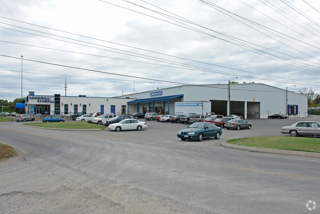
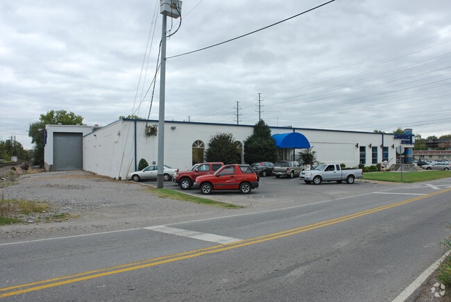
780 Berry Rd
118-07-0-220
Edenwold City Subdivision
Stripcommercialcenter
N. SIDE OF BERRY ROAD E. SIDE L & N. RAILROAD
AE
Davidson
47037C0357J
Tennessee
0
3.71 AC
2025
IBD
017200
Nashville
15,688 SF
Nashville-Davidson--Murfreesboro--Franklin, TN
DEMOGRAPHICS near 780 Berry Rd
1 Mile
3 Mile
5 Mile
2024 Total Population
9,252
102,305
247,817
2029 Population
9,272
103,593
249,263
Pop Growth 2024-2029
+ 0.22%
+ 1.26%
+ 0.58%
Average Age
35
35
36
2024 Total Households
4,722
46,963
110,936
HH Growth 2024-2029
(0.34%)
+ 1.72%
+ 0.85%
Median Household Inc
$81,133
$69,027
$66,864
Avg Household Size
1.90
1.90
2.00
2024 Avg HH Vehicles
2.00
1.00
1.00
Median Home Value
$613,582
$552,956
$495,569
Median Year Built
2008
1999
1986
Nearby Places
Map Layers
Map Styles
 Street
 Aerial
- Restaurants
- Banks
- Shops
- Fitness
- Groceries
PUBLIC TRANSPORTATION
COMMUTER RAIL
Riverfront (East Corridor Line - Tennessee Regional Transportation Authority Music City Star (Music City Star))
DRIVE
WALK
Distance
Riverfront (East Corridor Line - Tennessee Regional Transportation Authority Music City Star (Music City Star))
6 min
3.5 mi
AIRPORT
Nashville International
DRIVE
WALK
Distance
Nashville International
13 min
7.9 mi
Freight Ports
Port of Mobile
DRIVE
WALK
Distance
Port of Mobile
482 min
442.5 mi
Nearby Properties
Address
Land Use
TOTAL SIZE
Lot Size
Zoning
Address
Land Use
TOTAL SIZE
Lot Size
Zoning
2,092,890 SF
11.87 AC
DTC
Address
Land Use
TOTAL SIZE
Lot Size
Zoning
6,216 SF
131.92 AC
MULTI-ZONE
Address
Land Use
TOTAL SIZE
Lot Size
Zoning
819,428 SF
4.04 AC
DTC
Address
Land Use
TOTAL SIZE
Lot Size
Zoning
289,697 SF
10.18 AC
MUI-A
Address
Land Use
TOTAL SIZE
Lot Size
Zoning
30,648 SF
37.73 AC
ORI
Address
Land Use
TOTAL SIZE
Lot Size
Zoning
5,397 SF
36.19 AC
MULTI-ZONE
Address
Land Use
TOTAL SIZE
Lot Size
Zoning
7.49 AC
MULTI-ZONE
Address
Land Use
TOTAL SIZE
Lot Size
Zoning
5.32 AC
DTC
Address
Land Use
TOTAL SIZE
Lot Size
Zoning
1,339,972 SF
16.18 AC
ORI
Address
Land Use
TOTAL SIZE
Lot Size
Zoning
7.18 AC
MULTI-ZONE
Address
Land Use
TOTAL SIZE
Lot Size
Zoning
17.48 AC
MUG
Address
Land Use
TOTAL SIZE
Lot Size
Zoning
57,264 SF
7.80 AC
MUI
Address
Land Use
TOTAL SIZE
Lot Size
Zoning
24.42 AC
ORI
Address
Land Use
TOTAL SIZE
Lot Size
Zoning
13,764 SF
21 AC
SCR
Address
Land Use
TOTAL SIZE
Lot Size
Zoning
681,630 SF
1.24 AC
DTC
Address
Land Use
TOTAL SIZE
Lot Size
Zoning
28.23 AC
MULTI-ZONE
Address
Land Use
TOTAL SIZE
Lot Size
Zoning
502,586 SF
0.99 AC
MULTI-ZONE
Address
Land Use
TOTAL SIZE
Lot Size
Zoning
15.48 AC
MUI
Address
Land Use
TOTAL SIZE
Lot Size
Zoning
3.81 AC
MULTI-ZONE
Address
Land Use
TOTAL SIZE
Lot Size
Zoning
3.11 AC
MULTIZONE
Address
Land Use
TOTAL SIZE
Lot Size
Zoning
622,396 SF
2.75 AC
Address
Land Use
TOTAL SIZE
Lot Size
Zoning
112,896 SF
3.40 AC
MULTIZONE
Address
Land Use
TOTAL SIZE
Lot Size
Zoning
17.03 AC
ORI
Address
Land Use
TOTAL SIZE
Lot Size
Zoning
564,166 SF
1.62 AC
DTC
Address
Land Use
TOTAL SIZE
Lot Size
Zoning
207,950 SF
3.47 AC
RM20
Address
Land Use
TOTAL SIZE
Lot Size
Zoning
1.97 AC
DTC
Address
Land Use
TOTAL SIZE
Lot Size
Zoning
2.58 AC
MULTI-ZONE
Address
Land Use
TOTAL SIZE
Lot Size
Zoning
15.33 AC
MULTI-ZONE
Address
Land Use
TOTAL SIZE
Lot Size
Zoning
103,996 SF
88,270 AC
MULTIZONE
Address
Land Use
TOTAL SIZE
Lot Size
Zoning
205,783 SF
1.02 AC
DTC
The World's #1 Commercial Real Estate Marketplace
Connect with us
© 2026 CoStar Group
The information above has been obtained from sources believed reliable. While we do not doubt its accuracy we have not verified it and make no guarantee, warranty or representation about it. It is your responsibility to independently confirm its accuracy and completeness. Any projections, opinions, assumptions, or estimates used are for example only and do not represent the current or future performance of the property. The value of this transaction to you depends on tax and other factors which should be evaluated by your tax, financial, and legal advisors. You and your advisors should conduct a careful, independent investigation of the property to determine to your satisfaction the suitability of the property for your needs.