Property Record
780 E 39Th Pl, Yuma, AZ 85365
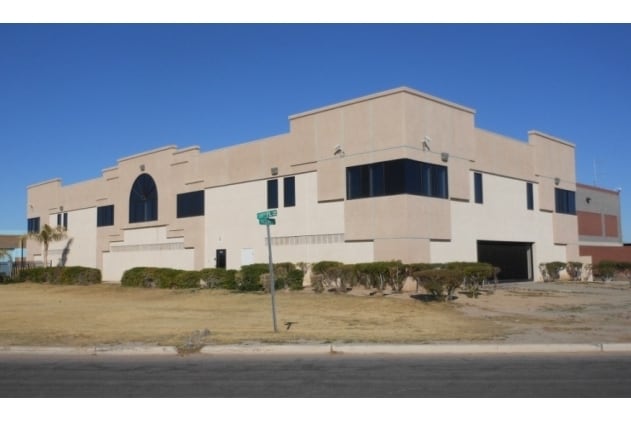

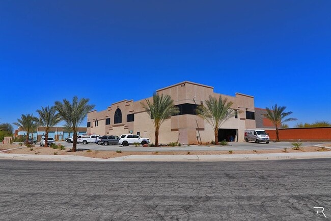
Property Detail
780 E 39Th Pl
695-61-010
SUBDIVISION: TRIPLE S INDUSTRIAL PARK LOT: 10 SECTION: 10 TOWNSHIP: 09S RANGE: 23W
Officebuilding
Yuma
LI
Arizona
C and X Area of minimal flood hazard, usually depicted on FIRMs as above the 500-year flood level.
10
2025
0.84 AC
2026
Yuma & El Centro
001001
Other Market Areas
30,096 SF
Yuma, AZ
NEARBY LISTINGS FOR SALE OR LEASE
DEMOGRAPHICS near 780 E 39Th Pl
1 mile
3 mile
5 mile
2024 Total Population
1,855
38,235
99,394
2029 Population
2,054
41,375
107,432
Pop Growth 2024-2029
+ 10.73%
+ 8.21%
+ 8.09%
Average Age
50
38
38
2024 Total Households
901
14,253
35,447
HH Growth 2024-2029
+ 11.21%
+ 9.40%
+ 9.24%
Median Household Inc
$53,032
$58,626
$61,738
Avg Household Size
2.10
2.50
2.70
2024 Avg HH Vehicles
1.00
2.00
2.00
Median Home Value
$120,220
$216,313
$237,873
Median Year Built
1986
1982
1987
Nearby Places
Map Layers
Map Styles
 Street
 Aerial
Transit
 Traffic
 Biking
Places
Listings with unknown addresses are not visible on the map
- Restaurants
- Banks
- Shops
- Fitness
- Groceries
PUBLIC TRANSPORTATION
COMMUTER RAIL
Drive
Walk
Distance
12 min
5.7 mi
AIRPORT
Yuma International
Drive
Walk
Distance
Yuma International
4 min
1.1 mi
SALE & LEASE HISTORY
LISTING DATE
SALE/LEASE

May 31, 2017
For Lease
Mar 24, 2020
For Lease
Nearby Properties
Address
Land Use
TOTAL SIZE
Lot Size
Zoning
Address
Land Use
TOTAL SIZE
Lot Size
Zoning
383,999 SF
87.91 AC
R-1-6
Address
Land Use
TOTAL SIZE
Lot Size
Zoning
163,094 SF
27 AC
AG
Address
Land Use
TOTAL SIZE
Lot Size
Zoning
383,461 SF
93.30 AC
LI
Address
Land Use
TOTAL SIZE
Lot Size
Zoning
61,000 SF
36.50 AC
B-2
Address
Land Use
TOTAL SIZE
Lot Size
Zoning
79,891 SF
8.97 AC
R-1-6
Address
Land Use
TOTAL SIZE
Lot Size
Zoning
300,746 SF
17.42 AC
LI
Address
Land Use
TOTAL SIZE
Lot Size
Zoning
15,815 SF
4.40 AC
LI
Address
Land Use
TOTAL SIZE
Lot Size
Zoning
212,439 SF
20.28 AC
B-1
Address
Land Use
TOTAL SIZE
Lot Size
Zoning
407,940 SF
24.04 AC
HI
Address
Land Use
TOTAL SIZE
Lot Size
Zoning
51,586 SF
6.71 AC
B-2
Address
Land Use
TOTAL SIZE
Lot Size
Zoning
119,714 SF
6.75 AC
C-2
Address
Land Use
TOTAL SIZE
Lot Size
Zoning
264,412 SF
28.05 AC
LI
Address
Land Use
TOTAL SIZE
Lot Size
Zoning
114,420 SF
6.13 AC
B-2
Address
Land Use
TOTAL SIZE
Lot Size
Zoning
50,918 SF
3.85 AC
TR
Address
Land Use
TOTAL SIZE
Lot Size
Zoning
77,301 SF
2.25 AC
B-2
Address
Land Use
TOTAL SIZE
Lot Size
Zoning
68,961 SF
3.23 AC
B-2
Address
Land Use
TOTAL SIZE
Lot Size
Zoning
168,098 SF
8.77 AC
R-3
Address
Land Use
TOTAL SIZE
Lot Size
Zoning
103,803 SF
22.50 AC
LI
Address
Land Use
TOTAL SIZE
Lot Size
Zoning
33,765 SF
2.81 AC
B-2
Address
Land Use
TOTAL SIZE
Lot Size
Zoning
97,660 SF
8.81 AC
B-2
Address
Land Use
TOTAL SIZE
Lot Size
Zoning
91,382 SF
52.31 AC
HI
Address
Land Use
TOTAL SIZE
Lot Size
Zoning
56,885 SF
22.04 AC
R-1-6
Address
Land Use
TOTAL SIZE
Lot Size
Zoning
96,278 SF
9.71 AC
B-1
Address
Land Use
TOTAL SIZE
Lot Size
Zoning
148,326 SF
8.27 AC
R-3
Address
Land Use
TOTAL SIZE
Lot Size
Zoning
69,315 SF
22.47 AC
LI
Address
Land Use
TOTAL SIZE
Lot Size
Zoning
57,210 SF
7.19 AC
B-1
Address
Land Use
TOTAL SIZE
Lot Size
Zoning
67,495 SF
5.21 AC
B-2
Address
Land Use
TOTAL SIZE
Lot Size
Zoning
106,435 SF
3.75 AC
B-1
Address
Land Use
TOTAL SIZE
Lot Size
Zoning
40,015 SF
75 AC
HI
The World's #1 Commercial Real Estate Marketplace
Connect with us
© 2026 CoStar Group
The information above has been obtained from sources believed reliable. While we do not doubt its accuracy we have not verified it and make no guarantee, warranty or representation about it. It is your responsibility to independently confirm its accuracy and completeness. Any projections, opinions, assumptions, or estimates used are for example only and do not represent the current or future performance of the property. The value of this transaction to you depends on tax and other factors which should be evaluated by your tax, financial, and legal advisors. You and your advisors should conduct a careful, independent investigation of the property to determine to your satisfaction the suitability of the property for your needs.