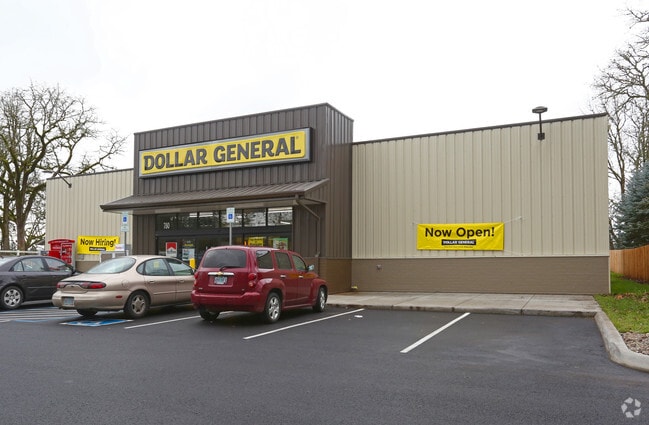
Property Record
780 N 2Nd St, Jefferson, OR 97352

Property Detail
780 N 2Nd St
537048
ACRES .99
Officebuilding
Marion
MU-H
Oregon
B and X Area of moderate flood hazard, usually the area between the limits of the 100-year and 500-year floods.
0.99 AC
2024
Marion County
2025
Portland
010802
Salem, OR
7,435 SF
NEARBY LISTINGS FOR SALE OR LEASE
-
-
View all Jefferson listings for sale on LoopNet.com
DEMOGRAPHICS near 780 N 2Nd St
1 mile
3 mile
5 mile
2025 Total Population
3,222
5,683
11,619
2030 Population
3,233
5,685
11,803
Pop Growth 2025-2030
+ 0.34%
+ 0.04%
+ 1.58%
Average Age
39
41
42
2025 Total Households
1,107
1,998
4,134
HH Growth 2025-2030
+ 0.45%
+ 0.15%
+ 1.67%
Median Household Inc
$100,510
$102,037
$113,066
Avg Household Size
2.90
2.80
2.80
2025 Avg HH Vehicles
2.00
3.00
3.00
Median Home Value
$405,871
$444,351
$503,480
Median Year Built
1979
1979
1989
Nearby Places
Map Layers
Map Styles
 Street
 Aerial
Layers
 Traffic
 Biking
Places
Listings with unknown addresses are not visible on the map
- Restaurants
- Banks
- Shops
- Fitness
- Groceries
PUBLIC TRANSPORTATION
COMMUTER RAIL
Albany Amtrak Station (Amtrak Cascades - Amtrak, Coast Starlight - Amtrak)
Drive
Walk
Distance
Albany Amtrak Station (Amtrak Cascades - Amtrak, Coast Starlight - Amtrak)
16 min
10.0 mi
Freight Ports
Port of Portland
Drive
Walk
Distance
Port of Portland
82 min
64.5 mi
Nearby Properties
Address
Land Use
TOTAL SIZE
Lot Size
Zoning
Address
Land Use
TOTAL SIZE
Lot Size
Zoning
81,945 SF
4.15 AC
MU-H
Address
Land Use
TOTAL SIZE
Lot Size
Zoning
51,596 SF
4.45 AC
GC
Address
Land Use
TOTAL SIZE
Lot Size
Zoning
12.36 AC
GI
Address
Land Use
TOTAL SIZE
Lot Size
Zoning
29,148 SF
1.34 AC
R3
Address
Land Use
TOTAL SIZE
Lot Size
Zoning
23,270 SF
1.31 AC
R3
Address
Land Use
TOTAL SIZE
Lot Size
Zoning
7,095 SF
0.82 AC
MU-H
Address
Land Use
TOTAL SIZE
Lot Size
Zoning
19,000 SF
6.19 AC
GC
Address
Land Use
TOTAL SIZE
Lot Size
Zoning
16,200 SF
4.91 AC
GC
Address
Land Use
TOTAL SIZE
Lot Size
Zoning
640,776 SF
26.76 AC
EFU
Address
Land Use
TOTAL SIZE
Lot Size
Zoning
8,640 SF
0.67 AC
IG
Address
Land Use
TOTAL SIZE
Lot Size
Zoning
5.70 AC
I
Address
Land Use
TOTAL SIZE
Lot Size
Zoning
51,596 SF
1.50 AC
GC
Address
Land Use
TOTAL SIZE
Lot Size
Zoning
14,224 SF
1.64 AC
I
Address
Land Use
TOTAL SIZE
Lot Size
Zoning
5,212 SF
0.78 AC
MU-H
Address
Land Use
TOTAL SIZE
Lot Size
Zoning
10,956 SF
1.01 AC
R3
Address
Land Use
TOTAL SIZE
Lot Size
Zoning
2.12 AC
I
Address
Land Use
TOTAL SIZE
Lot Size
Zoning
13,370 SF
133.88 AC
EFU
Address
Land Use
TOTAL SIZE
Lot Size
Zoning
23.07 AC
F/F
Address
Land Use
TOTAL SIZE
Lot Size
Zoning
18,444 SF
219 AC
EFU
Address
Land Use
TOTAL SIZE
Lot Size
Zoning
8,617 SF
59.27 AC
SA
Address
Land Use
TOTAL SIZE
Lot Size
Zoning
10,894 SF
115.67 AC
EFU
Address
Land Use
TOTAL SIZE
Lot Size
Zoning
7,064 SF
46.65 AC
EFU
Address
Land Use
TOTAL SIZE
Lot Size
Zoning
2,658 SF
0.34 AC
MU-M
Address
Land Use
TOTAL SIZE
Lot Size
Zoning
6,240 SF
0.43 AC
R3
Address
Land Use
TOTAL SIZE
Lot Size
Zoning
20,200 SF
1.70 AC
GI
Address
Land Use
TOTAL SIZE
Lot Size
Zoning
6,000 SF
1.98 AC
I
Address
Land Use
TOTAL SIZE
Lot Size
Zoning
18,556 SF
10.53 AC
EFU
Address
Land Use
TOTAL SIZE
Lot Size
Zoning
5,760 SF
0.19 AC
MU-M
The World's #1 Commercial Real Estate Marketplace
Connect with us
© 2026 CoStar Group
The information above has been obtained from sources believed reliable. While we do not doubt its accuracy we have not verified it and make no guarantee, warranty or representation about it. It is your responsibility to independently confirm its accuracy and completeness. Any projections, opinions, assumptions, or estimates used are for example only and do not represent the current or future performance of the property. The value of this transaction to you depends on tax and other factors which should be evaluated by your tax, financial, and legal advisors. You and your advisors should conduct a careful, independent investigation of the property to determine to your satisfaction the suitability of the property for your needs.