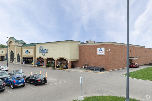
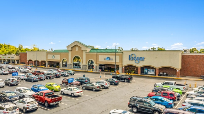
Property Record
780 Northwoods Blvd, Vandalia, OH 45377

NEARBY LISTINGS FOR SALE OR LEASE
-
-
View all Vandalia listings for sale on LoopNet.com
Property Detail
780 Northwoods Blvd
Dayton, OH
The Shoppes At Northwoods
B02-00315-0046
5 THE SHOPPES AT NORTHWOODS SEC 3
Supermarket
Montgomery
2023
Ohio
2024
14.50 AC
115002
North Dayton
92,985 SF
Cincinnati/Dayton
DEMOGRAPHICS near 780 Northwoods Blvd
1 Mile
3 Mile
5 Mile
2024 Total Population
4,487
19,801
67,566
2029 Population
4,382
19,615
67,408
Pop Growth 2024-2029
(2.34%)
(0.94%)
(0.23%)
Average Age
42
42
41
2024 Total Households
2,010
8,502
27,776
HH Growth 2024-2029
(2.39%)
(1.12%)
(0.36%)
Median Household Inc
$62,325
$73,917
$72,807
Avg Household Size
2.20
2.30
2.40
2024 Avg HH Vehicles
2.00
2.00
2.00
Median Home Value
$154,879
$190,929
$181,572
Median Year Built
1966
1972
1973
Nearby Places
Map Layers
Map Styles
 Street
 Aerial
- Restaurants
- Banks
- Shops
- Fitness
- Groceries
PUBLIC TRANSPORTATION
AIRPORT
James M Cox Dayton International
DRIVE
WALK
Distance
James M Cox Dayton International
11 min
4.9 mi
Freight Ports
Port of Toledo
DRIVE
WALK
Distance
Port of Toledo
166 min
143.3 mi
SALE & LEASE HISTORY
LISTING DATE
SALE/LEASE

Oct 02, 2024
For Sale
May 05, 2017
For Lease
Feb 25, 2021
For Sale
Apr 05, 2024
For Lease
Nearby Properties
Address
Land Use
TOTAL SIZE
Lot Size
Zoning
Address
Land Use
TOTAL SIZE
Lot Size
Zoning
340,028 SF
37.51 AC
Address
Land Use
TOTAL SIZE
Lot Size
Zoning
573,962 SF
879.20 AC
Address
Land Use
TOTAL SIZE
Lot Size
Zoning
704,988 SF
49.15 AC
Address
Land Use
TOTAL SIZE
Lot Size
Zoning
664,824 SF
1,128.84 AC
Address
Land Use
TOTAL SIZE
Lot Size
Zoning
54,635 SF
17.25 AC
Address
Land Use
TOTAL SIZE
Lot Size
Zoning
37.86 AC
Address
Land Use
TOTAL SIZE
Lot Size
Zoning
135,300 SF
13.75 AC
Address
Land Use
TOTAL SIZE
Lot Size
Zoning
730,000 SF
56.40 AC
Address
Land Use
TOTAL SIZE
Lot Size
Zoning
45,980 SF
6.05 AC
Address
Land Use
TOTAL SIZE
Lot Size
Zoning
433,792 SF
34.46 AC
Address
Land Use
TOTAL SIZE
Lot Size
Zoning
23,980 SF
9.47 AC
Address
Land Use
TOTAL SIZE
Lot Size
Zoning
425,641 SF
33.79 AC
Address
Land Use
TOTAL SIZE
Lot Size
Zoning
730,000 SF
56.40 AC
Address
Land Use
TOTAL SIZE
Lot Size
Zoning
12,660 SF
20.22 AC
Address
Land Use
TOTAL SIZE
Lot Size
Zoning
Address
Land Use
TOTAL SIZE
Lot Size
Zoning
172,753 SF
23.76 AC
Address
Land Use
TOTAL SIZE
Lot Size
Zoning
143,980 SF
35.40 AC
Address
Land Use
TOTAL SIZE
Lot Size
Zoning
3,420 SF
12.59 AC
Address
Land Use
TOTAL SIZE
Lot Size
Zoning
43,850 SF
13.15 AC
Address
Land Use
TOTAL SIZE
Lot Size
Zoning
179,704 SF
18.68 AC
Address
Land Use
TOTAL SIZE
Lot Size
Zoning
76,156 SF
97.13 AC
Address
Land Use
TOTAL SIZE
Lot Size
Zoning
2,430 SF
371.47 AC
Address
Land Use
TOTAL SIZE
Lot Size
Zoning
126,038 SF
13.78 AC
Address
Land Use
TOTAL SIZE
Lot Size
Zoning
184,413 SF
9.39 AC
Address
Land Use
TOTAL SIZE
Lot Size
Zoning
165,018 SF
19.77 AC
Address
Land Use
TOTAL SIZE
Lot Size
Zoning
164,834 SF
24.53 AC
Address
Land Use
TOTAL SIZE
Lot Size
Zoning
12,203 SF
9.22 AC
Address
Land Use
TOTAL SIZE
Lot Size
Zoning
1,778 SF
10.62 AC
Address
Land Use
TOTAL SIZE
Lot Size
Zoning
198,560 SF
16.25 AC
The World's #1 Commercial Real Estate Marketplace
Connect with us
© 2025 CoStar Group
The information above has been obtained from sources believed reliable. While we do not doubt its accuracy we have not verified it and make no guarantee, warranty or representation about it. It is your responsibility to independently confirm its accuracy and completeness. Any projections, opinions, assumptions, or estimates used are for example only and do not represent the current or future performance of the property. The value of this transaction to you depends on tax and other factors which should be evaluated by your tax, financial, and legal advisors. You and your advisors should conduct a careful, independent investigation of the property to determine to your satisfaction the suitability of the property for your needs.