Property Record
780 W El Monte Way, Dinuba, CA 93618


NEARBY LISTINGS FOR SALE OR LEASE
Property Detail
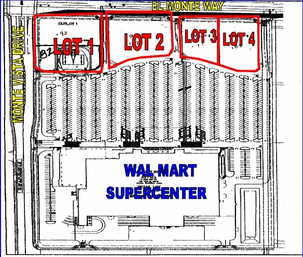
780 W El Monte Way
017-280-011-000
Parcel 4 Of Parcel Map 4844 In The City
Regionalshoppingcenterormallwithanchorstore
PARCEL 4 PARCEL MAP NO 4844 PM 49-49
X
Tulare
06107C0317E
California
2024
1.28 AC
2025
Dinuba
000502
Visalia/Porterville
8,365 SF
Visalia-Porterville, CA
DEMOGRAPHICS near 780 W El Monte Way
1 Mile
3 Mile
5 Mile
2024 Total Population
11,332
27,870
53,549
2029 Population
11,637
28,739
54,734
Pop Growth 2024-2029
+ 2.69%
+ 3.12%
+ 2.21%
Average Age
33
34
34
2024 Total Households
3,104
7,601
14,692
HH Growth 2024-2029
+ 2.64%
+ 3.10%
+ 2.18%
Median Household Inc
$55,753
$54,674
$55,465
Avg Household Size
3.60
3.60
3.60
2024 Avg HH Vehicles
2.00
2.00
2.00
Median Home Value
$264,623
$264,020
$262,755
Median Year Built
1976
1977
1978
Nearby Places
Map Layers
Map Styles
 Street
 Aerial
- Restaurants
- Banks
- Shops
- Fitness
- Groceries
PUBLIC TRANSPORTATION
AIRPORT
Fresno Yosemite International
DRIVE
WALK
Distance
Fresno Yosemite International
44 min
29.8 mi
Freight Ports
Port of Stockton
DRIVE
WALK
Distance
Port of Stockton
184 min
154.9 mi
Nearby Properties
Address
Land Use
TOTAL SIZE
Lot Size
Zoning
Address
Land Use
TOTAL SIZE
Lot Size
Zoning
1,022,425 SF
97.93 AC
M-1
Address
Land Use
TOTAL SIZE
Lot Size
Zoning
311,815 SF
18.19 AC
M-1
Address
Land Use
TOTAL SIZE
Lot Size
Zoning
23.40 AC
Address
Land Use
TOTAL SIZE
Lot Size
Zoning
89,902 SF
32.05 AC
AE20
Address
Land Use
TOTAL SIZE
Lot Size
Zoning
52,140 SF
10 AC
M-1
Address
Land Use
TOTAL SIZE
Lot Size
Zoning
68,775 SF
4.68 AC
RM-2
Address
Land Use
TOTAL SIZE
Lot Size
Zoning
135.31 AC
Address
Land Use
TOTAL SIZE
Lot Size
Zoning
57,608 SF
44.37 AC
AE-20
Address
Land Use
TOTAL SIZE
Lot Size
Zoning
81,771 SF
5.37 AC
RM-2
Address
Land Use
TOTAL SIZE
Lot Size
Zoning
38,285 SF
4.53 AC
C-3
Address
Land Use
TOTAL SIZE
Lot Size
Zoning
38,907 SF
1.24 AC
C-4
Address
Land Use
TOTAL SIZE
Lot Size
Zoning
92,923 SF
12.33 AC
M-1
Address
Land Use
TOTAL SIZE
Lot Size
Zoning
2,998 SF
1.09 AC
C-4
Address
Land Use
TOTAL SIZE
Lot Size
Zoning
27.34 AC
AE-20
Address
Land Use
TOTAL SIZE
Lot Size
Zoning
26,692 SF
1.50 AC
Address
Land Use
TOTAL SIZE
Lot Size
Zoning
38,278 SF
1.38 AC
C-4
Address
Land Use
TOTAL SIZE
Lot Size
Zoning
10,893 SF
1.27 AC
C-4
Address
Land Use
TOTAL SIZE
Lot Size
Zoning
19,092 SF
2.85 AC
C4
Address
Land Use
TOTAL SIZE
Lot Size
Zoning
5.08 AC
Address
Land Use
TOTAL SIZE
Lot Size
Zoning
14,837 SF
1.39 AC
C-3P
Address
Land Use
TOTAL SIZE
Lot Size
Zoning
4.94 AC
Address
Land Use
TOTAL SIZE
Lot Size
Zoning
9.42 AC
Address
Land Use
TOTAL SIZE
Lot Size
Zoning
2.51 AC
Address
Land Use
TOTAL SIZE
Lot Size
Zoning
2.22 AC
Address
Land Use
TOTAL SIZE
Lot Size
Zoning
480 SF
4.89 AC
M-1
Address
Land Use
TOTAL SIZE
Lot Size
Zoning
7,502 SF
1.75 AC
Address
Land Use
TOTAL SIZE
Lot Size
Zoning
2,900 SF
4.95 AC
Address
Land Use
TOTAL SIZE
Lot Size
Zoning
17,388 SF
1.61 AC
C-3
Address
Land Use
TOTAL SIZE
Lot Size
Zoning
35,285 SF
14.65 AC
AE20
The World's #1 Commercial Real Estate Marketplace
Connect with us
© 2025 CoStar Group
The information above has been obtained from sources believed reliable. While we do not doubt its accuracy we have not verified it and make no guarantee, warranty or representation about it. It is your responsibility to independently confirm its accuracy and completeness. Any projections, opinions, assumptions, or estimates used are for example only and do not represent the current or future performance of the property. The value of this transaction to you depends on tax and other factors which should be evaluated by your tax, financial, and legal advisors. You and your advisors should conduct a careful, independent investigation of the property to determine to your satisfaction the suitability of the property for your needs.