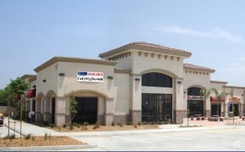
Property Record
780 Ramona Expy, Perris, CA 92571


Current Lease Availabilities
NEARBY LISTINGS FOR SALE OR LEASE
Property Detail
780 Ramona Expy
Riverside-San Bernardino-Ontario, CA
Parcel Map No 31677
302-260-073
1.19 ACRES IN PAR 2 PM 225/058 PM 31677
Storebuilding
Riverside
X
California
06065C1430H
2
2024
1.19 AC
2025
Moreno Valley/Perris
042625
Inland Empire (California)
10,432 SF
DEMOGRAPHICS near 780 Ramona Expy
1 Mile
3 Mile
5 Mile
2024 Total Population
323
48,796
162,945
2029 Population
333
51,063
171,380
Pop Growth 2024-2029
+ 3.10%
+ 4.65%
+ 5.18%
Average Age
34
33
34
2024 Total Households
82
11,186
39,461
HH Growth 2024-2029
+ 2.44%
+ 4.13%
+ 4.82%
Median Household Inc
$114,583
$79,893
$76,476
Avg Household Size
3.60
4.10
3.90
2024 Avg HH Vehicles
3.00
3.00
3.00
Median Home Value
$418,965
$393,856
$381,437
Median Year Built
2001
1996
1991
Nearby Places
Map Layers
Map Styles
 Street
 Aerial
- Restaurants
- Banks
- Shops
- Fitness
- Groceries
PUBLIC TRANSPORTATION
AIRPORT
Ontario International
DRIVE
WALK
Distance
Ontario International
28 min
30.9 mi
Nearby Properties
Address
Land Use
TOTAL SIZE
Lot Size
Zoning
Address
Land Use
TOTAL SIZE
Lot Size
Zoning
1,530,974 SF
71.21 AC
Address
Land Use
TOTAL SIZE
Lot Size
Zoning
1,189,664 SF
55.26 AC
Address
Land Use
TOTAL SIZE
Lot Size
Zoning
1,224,874 SF
59.05 AC
Address
Land Use
TOTAL SIZE
Lot Size
Zoning
1,009,869 SF
46.76 AC
Address
Land Use
TOTAL SIZE
Lot Size
Zoning
783,407 SF
36.72 AC
Address
Land Use
TOTAL SIZE
Lot Size
Zoning
656,695 SF
30.75 AC
RA5
Address
Land Use
TOTAL SIZE
Lot Size
Zoning
1,138,800 SF
43.93 AC
Address
Land Use
TOTAL SIZE
Lot Size
Zoning
1,309,754 SF
57.79 AC
IL
Address
Land Use
TOTAL SIZE
Lot Size
Zoning
1,331,763 SF
62.60 AC
Address
Land Use
TOTAL SIZE
Lot Size
Zoning
579,708 SF
17.70 AC
LI
Address
Land Use
TOTAL SIZE
Lot Size
Zoning
343 SF
83.52 AC
LI
Address
Land Use
TOTAL SIZE
Lot Size
Zoning
678,087 SF
30.24 AC
Address
Land Use
TOTAL SIZE
Lot Size
Zoning
83.15 AC
Address
Land Use
TOTAL SIZE
Lot Size
Zoning
1,461,146 SF
72.62 AC
Address
Land Use
TOTAL SIZE
Lot Size
Zoning
436,350 SF
19.47 AC
Address
Land Use
TOTAL SIZE
Lot Size
Zoning
1,364,580 SF
80.02 AC
Address
Land Use
TOTAL SIZE
Lot Size
Zoning
692,465 SF
34.46 AC
Address
Land Use
TOTAL SIZE
Lot Size
Zoning
325,560 SF
16.65 AC
Address
Land Use
TOTAL SIZE
Lot Size
Zoning
695,786 SF
92.37 AC
Address
Land Use
TOTAL SIZE
Lot Size
Zoning
340,285 SF
14.39 AC
Address
Land Use
TOTAL SIZE
Lot Size
Zoning
1,297,200 SF
57.36 AC
Address
Land Use
TOTAL SIZE
Lot Size
Zoning
1,172,289 SF
41.82 AC
Address
Land Use
TOTAL SIZE
Lot Size
Zoning
348,375 SF
21.80 AC
Address
Land Use
TOTAL SIZE
Lot Size
Zoning
332,377 SF
21.12 AC
Address
Land Use
TOTAL SIZE
Lot Size
Zoning
1,582,985 SF
83.28 AC
LI
Address
Land Use
TOTAL SIZE
Lot Size
Zoning
285,482 SF
9.65 AC
Address
Land Use
TOTAL SIZE
Lot Size
Zoning
800,218 SF
37.43 AC
Address
Land Use
TOTAL SIZE
Lot Size
Zoning
1,387,899 SF
49.40 AC
The World's #1 Commercial Real Estate Marketplace
Connect with us
© 2026 CoStar Group
The information above has been obtained from sources believed reliable. While we do not doubt its accuracy we have not verified it and make no guarantee, warranty or representation about it. It is your responsibility to independently confirm its accuracy and completeness. Any projections, opinions, assumptions, or estimates used are for example only and do not represent the current or future performance of the property. The value of this transaction to you depends on tax and other factors which should be evaluated by your tax, financial, and legal advisors. You and your advisors should conduct a careful, independent investigation of the property to determine to your satisfaction the suitability of the property for your needs.