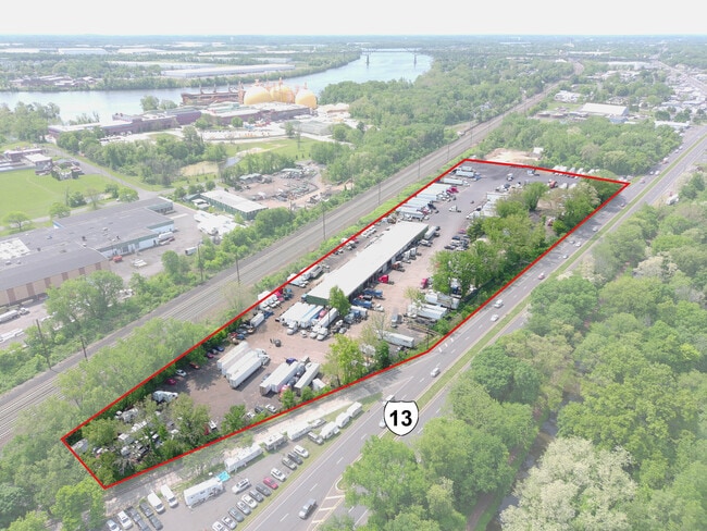
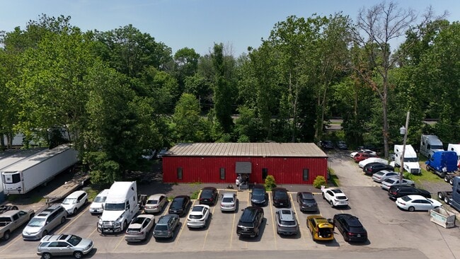
Property Record
Route 13, , PA
This Property Is For Sale
NEARBY LISTINGS FOR SALE OR LEASE
Property Detail
Route 13
Philadelphia-Camden-Wilmington, PA-NJ-DE-MD
Levittown
46-006-030-002
1.56A LOT 350FT S S US13 & 1520FT W LEVITTOWN PAR KWAY
Commercialnec
Bucks
X
Pennsylvania
34005C0014F
350ft
2024
1.56 AC
2025
Bucks
105900
Philadelphia
DEMOGRAPHICS near Route 13
1 Mile
3 Mile
5 Mile
2024 Total Population
7,653
72,854
161,509
2029 Population
7,605
72,743
161,442
Pop Growth 2024-2029
(0.63%)
(0.15%)
(0.04%)
Average Age
41
41
41
2024 Total Households
2,889
27,277
60,947
HH Growth 2024-2029
(0.73%)
(0.17%)
(0.06%)
Median Household Inc
$77,325
$86,418
$86,631
Avg Household Size
2.60
2.60
2.60
2024 Avg HH Vehicles
2.00
2.00
2.00
Median Home Value
$244,641
$249,522
$271,118
Median Year Built
1955
1956
1958
Nearby Places
- Restaurants
- Banks
- Shops
- Fitness
- Groceries
PUBLIC TRANSPORTATION
COMMUTER RAIL
Levittown (R7 - Southeastern Pennsylvania Transportation Authority Regional Rail (SEPTA Regional Rail))
DRIVE
WALK
Distance
Levittown (R7 - Southeastern Pennsylvania Transportation Authority Regional Rail (SEPTA Regional Rail))
1 min
0.4 mi
Bristol (R7 - Southeastern Pennsylvania Transportation Authority Regional Rail (SEPTA Regional Rail))
DRIVE
WALK
Distance
Bristol (R7 - Southeastern Pennsylvania Transportation Authority Regional Rail (SEPTA Regional Rail))
7 min
3.3 mi
AIRPORT
Trenton Mercer
DRIVE
WALK
Distance
Trenton Mercer
21 min
12.2 mi
Philadelphia International
DRIVE
WALK
Distance
Philadelphia International
53 min
35.0 mi
Freight Ports
Port of Philadelphia
DRIVE
WALK
Distance
Port of Philadelphia
32 min
21.4 mi
Nearby Properties
Address
Land Use
TOTAL SIZE
Lot Size
Zoning
Address
Land Use
TOTAL SIZE
Lot Size
Zoning
65.99 AC
Address
Land Use
TOTAL SIZE
Lot Size
Zoning
22,300 SF
59.13 AC
Address
Land Use
TOTAL SIZE
Lot Size
Zoning
16,960 SF
107.84 AC
Address
Land Use
TOTAL SIZE
Lot Size
Zoning
Address
Land Use
TOTAL SIZE
Lot Size
Zoning
77.35 AC
I-2
Address
Land Use
TOTAL SIZE
Lot Size
Zoning
2,019 SF
28.85 AC
I-2
Address
Land Use
TOTAL SIZE
Lot Size
Zoning
486,812 SF
44.42 AC
Address
Land Use
TOTAL SIZE
Lot Size
Zoning
Address
Land Use
TOTAL SIZE
Lot Size
Zoning
Address
Land Use
TOTAL SIZE
Lot Size
Zoning
Address
Land Use
TOTAL SIZE
Lot Size
Zoning
Address
Land Use
TOTAL SIZE
Lot Size
Zoning
Address
Land Use
TOTAL SIZE
Lot Size
Zoning
Address
Land Use
TOTAL SIZE
Lot Size
Zoning
19,188 SF
29.52 AC
Address
Land Use
TOTAL SIZE
Lot Size
Zoning
23.38 AC
Address
Land Use
TOTAL SIZE
Lot Size
Zoning
Address
Land Use
TOTAL SIZE
Lot Size
Zoning
27.99 AC
Address
Land Use
TOTAL SIZE
Lot Size
Zoning
37.98 AC
I-2
Address
Land Use
TOTAL SIZE
Lot Size
Zoning
Address
Land Use
TOTAL SIZE
Lot Size
Zoning
300,700 SF
30.82 AC
Address
Land Use
TOTAL SIZE
Lot Size
Zoning
23.14 AC
I-2
Address
Land Use
TOTAL SIZE
Lot Size
Zoning
27,600 SF
13.26 AC
I-2
Address
Land Use
TOTAL SIZE
Lot Size
Zoning
6.08 AC
Address
Land Use
TOTAL SIZE
Lot Size
Zoning
22.45 AC
I-2
Address
Land Use
TOTAL SIZE
Lot Size
Zoning
131,702 SF
10.21 AC
Address
Land Use
TOTAL SIZE
Lot Size
Zoning
29 AC
I-2
Address
Land Use
TOTAL SIZE
Lot Size
Zoning
24,328 SF
16.99 AC
I-2
Address
Land Use
TOTAL SIZE
Lot Size
Zoning
13.67 AC
I-2
Address
Land Use
TOTAL SIZE
Lot Size
Zoning
102,000 SF
17.50 AC
Address
Land Use
TOTAL SIZE
Lot Size
Zoning
12.13 AC
The World's #1 Commercial Real Estate Marketplace
Connect with us
© 2025 CoStar Group
The information above has been obtained from sources believed reliable. While we do not doubt its accuracy we have not verified it and make no guarantee, warranty or representation about it. It is your responsibility to independently confirm its accuracy and completeness. Any projections, opinions, assumptions, or estimates used are for example only and do not represent the current or future performance of the property. The value of this transaction to you depends on tax and other factors which should be evaluated by your tax, financial, and legal advisors. You and your advisors should conduct a careful, independent investigation of the property to determine to your satisfaction the suitability of the property for your needs.