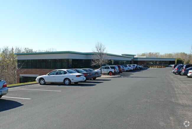
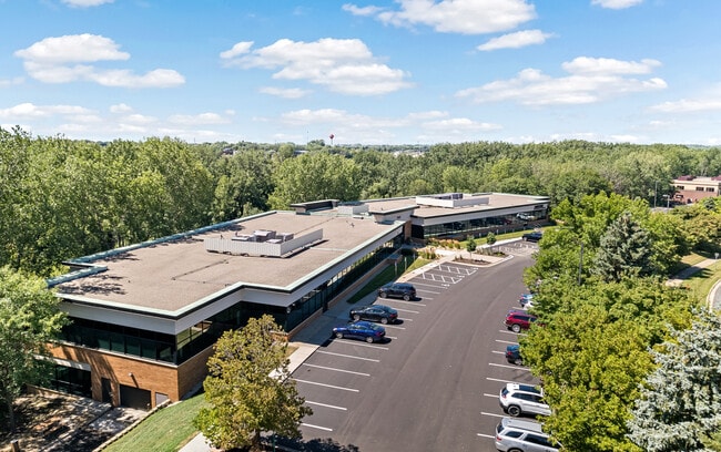
Property Record
7800 Equitable Dr, Eden Prairie, MN 55344

Save to a Folder
{{folder.Name}}
{{folder.ListingIds.length}} Properties
{{folder.ListingIds.length}} Property
Create a New Folder
Current Lease Availabilities
Property Detail
7800 Equitable Dr
10-116-22-34-0010
LOT 001 BLOCK 001 T MOUNT PLAT 3 IRREGULAR
Commercialnec
Hennepin
OFC
Minnesota
A Areas with a 1% annual chance of flooding and a 26% chance of flooding over the life of a 30-year mortgage.
1
2025
10.90 AC
2025
I-494 Corridor
026007
Minneapolis/St Paul
64,451 SF
Minneapolis-St. Paul-Bloomington, MN-WI
NEARBY LISTINGS FOR SALE OR LEASE
DEMOGRAPHICS near 7800 Equitable Dr
1 mile
3 mile
5 mile
2025 Total Population
7,696
52,384
143,137
2030 Population
7,674
52,351
143,567
Pop Growth 2025-2030
(0.29%)
(0.06%)
+ 0.30%
Average Age
38
41
43
2025 Total Households
3,366
21,125
58,516
HH Growth 2025-2030
(0.45%)
(0.09%)
+ 0.32%
Median Household Inc
$93,265
$118,331
$120,541
Avg Household Size
2.20
2.40
2.40
2025 Avg HH Vehicles
2.00
2.00
2.00
Median Home Value
$381,513
$471,433
$484,382
Median Year Built
1985
1987
1983
Nearby Places
Map Layers
Map Styles
 Street
 Aerial
Layers
 Traffic
 Biking
Places
Listings with unknown addresses are not visible on the map
- Restaurants
- Banks
- Shops
- Fitness
- Groceries
PUBLIC TRANSPORTATION
AIRPORT
Minneapolis-St Paul International/Wold-Chamberlain
Drive
Walk
Distance
Minneapolis-St Paul International/Wold-Chamberlain
21 min
13.7 mi
Freight Ports
Port Milwaukee
Drive
Walk
Distance
Port Milwaukee
390 min
350.8 mi
Nearby Properties
Address
Land Use
TOTAL SIZE
Lot Size
Zoning
Address
Land Use
TOTAL SIZE
Lot Size
Zoning
4.89 AC
Address
Land Use
TOTAL SIZE
Lot Size
Zoning
49,799 SF
4.96 AC
Address
Land Use
TOTAL SIZE
Lot Size
Zoning
49,757 SF
2.88 AC
Address
Land Use
TOTAL SIZE
Lot Size
Zoning
Address
Land Use
TOTAL SIZE
Lot Size
Zoning
136,782 SF
6.17 AC
Address
Land Use
TOTAL SIZE
Lot Size
Zoning
138,997 SF
14.03 AC
OFC
Address
Land Use
TOTAL SIZE
Lot Size
Zoning
3.15 AC
Address
Land Use
TOTAL SIZE
Lot Size
Zoning
Address
Land Use
TOTAL SIZE
Lot Size
Zoning
226,252 SF
5.40 AC
Address
Land Use
TOTAL SIZE
Lot Size
Zoning
216,984 SF
14.48 AC
RM25
Address
Land Use
TOTAL SIZE
Lot Size
Zoning
93,982 SF
9.33 AC
OFC
Address
Land Use
TOTAL SIZE
Lot Size
Zoning
314,234 SF
2.31 AC
RM25
Address
Land Use
TOTAL SIZE
Lot Size
Zoning
175,506 SF
14.32 AC
Address
Land Use
TOTAL SIZE
Lot Size
Zoning
10.01 AC
RM25
Address
Land Use
TOTAL SIZE
Lot Size
Zoning
327,536 SF
4.76 AC
CCOM
Address
Land Use
TOTAL SIZE
Lot Size
Zoning
166,989 SF
9.70 AC
RM25
Address
Land Use
TOTAL SIZE
Lot Size
Zoning
122,801 SF
8.41 AC
RM25
Address
Land Use
TOTAL SIZE
Lot Size
Zoning
181,201 SF
8.30 AC
OFC
Address
Land Use
TOTAL SIZE
Lot Size
Zoning
12.57 AC
RM25
Address
Land Use
TOTAL SIZE
Lot Size
Zoning
7.30 AC
RM25
Address
Land Use
TOTAL SIZE
Lot Size
Zoning
5.77 AC
RM25
Address
Land Use
TOTAL SIZE
Lot Size
Zoning
9.94 AC
RM25
Address
Land Use
TOTAL SIZE
Lot Size
Zoning
325,341 SF
35.31 AC
C-REG
Address
Land Use
TOTAL SIZE
Lot Size
Zoning
130,990 SF
18.27 AC
C-REG
Address
Land Use
TOTAL SIZE
Lot Size
Zoning
8.38 AC
PUD
Address
Land Use
TOTAL SIZE
Lot Size
Zoning
70,129 SF
13.03 AC
RM25
Address
Land Use
TOTAL SIZE
Lot Size
Zoning
298,582 SF
31.71 AC
OFC
Address
Land Use
TOTAL SIZE
Lot Size
Zoning
129,037 SF
16.73 AC
RM25
Address
Land Use
TOTAL SIZE
Lot Size
Zoning
206,200 SF
8.97 AC
RM25
Address
Land Use
TOTAL SIZE
Lot Size
Zoning
536,598 SF
53.84 AC
I-5
The World's #1 Commercial Real Estate Marketplace
Connect with us
© 2026 CoStar Group
The information above has been obtained from sources believed reliable. While we do not doubt its accuracy we have not verified it and make no guarantee, warranty or representation about it. It is your responsibility to independently confirm its accuracy and completeness. Any projections, opinions, assumptions, or estimates used are for example only and do not represent the current or future performance of the property. The value of this transaction to you depends on tax and other factors which should be evaluated by your tax, financial, and legal advisors. You and your advisors should conduct a careful, independent investigation of the property to determine to your satisfaction the suitability of the property for your needs.