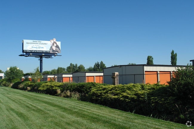
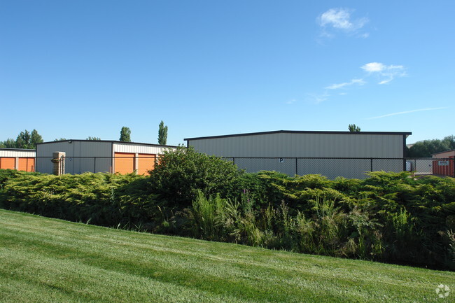
Property Record
7800 W State St, Boise, ID 83714
NEARBY LISTINGS FOR SALE OR LEASE
-
-
View all Boise listings for sale on LoopNet.com
Property Detail
7800 W State St
S0524244212
PAR #4312 OF SE4NW4 SEC 24 4N 1E #244310-B
Commercialbuilding
Ada
X
Idaho
16001C0166J
2.39 AC
2024
North Boise
2025
Boise City/Nampa
000305
Boise City, ID
32,430 SF
DEMOGRAPHICS near 7800 W State St
1 Mile
3 Mile
5 Mile
2024 Total Population
11,445
60,984
172,788
2029 Population
12,920
68,929
195,337
Pop Growth 2024-2029
+ 12.89%
+ 13.03%
+ 13.05%
Average Age
45
44
42
2024 Total Households
5,206
25,225
69,447
HH Growth 2024-2029
+ 13.14%
+ 13.31%
+ 13.35%
Median Household Inc
$81,571
$72,876
$73,973
Avg Household Size
2.20
2.30
2.40
2024 Avg HH Vehicles
2.00
2.00
2.00
Median Home Value
$453,852
$439,105
$459,044
Median Year Built
1995
1991
1992
Nearby Places
Map Layers
Map Styles
 Street
 Aerial
- Restaurants
- Banks
- Shops
- Fitness
- Groceries
PUBLIC TRANSPORTATION
AIRPORT
Boise Air Trml/Gowen Field
DRIVE
WALK
Distance
Boise Air Trml/Gowen Field
24 min
10.7 mi
Nearby Properties
Address
Land Use
TOTAL SIZE
Lot Size
Zoning
Address
Land Use
TOTAL SIZE
Lot Size
Zoning
386,225 SF
13.46 AC
ZC-270
Address
Land Use
TOTAL SIZE
Lot Size
Zoning
239,991 SF
8.09 AC
MU-DA
Address
Land Use
TOTAL SIZE
Lot Size
Zoning
245,000 SF
12.28 AC
R-2
Address
Land Use
TOTAL SIZE
Lot Size
Zoning
216,950 SF
9.03 AC
R-3
Address
Land Use
TOTAL SIZE
Lot Size
Zoning
151,285 SF
9.54 AC
R-1C
Address
Land Use
TOTAL SIZE
Lot Size
Zoning
150,584 SF
6.77 AC
M
Address
Land Use
TOTAL SIZE
Lot Size
Zoning
7.16 AC
ZC-251
Address
Land Use
TOTAL SIZE
Lot Size
Zoning
203,635 SF
4.76 AC
ZC-245
Address
Land Use
TOTAL SIZE
Lot Size
Zoning
176,494 SF
10.16 AC
R-1C
Address
Land Use
TOTAL SIZE
Lot Size
Zoning
167,603 SF
6.60 AC
C-2DA
Address
Land Use
TOTAL SIZE
Lot Size
Zoning
10.32 AC
ZC-251
Address
Land Use
TOTAL SIZE
Lot Size
Zoning
151,365 SF
12.03 AC
ZC-243
Address
Land Use
TOTAL SIZE
Lot Size
Zoning
129,827 SF
3.08 AC
MU-DA
Address
Land Use
TOTAL SIZE
Lot Size
Zoning
124,286 SF
5 AC
R-3
Address
Land Use
TOTAL SIZE
Lot Size
Zoning
102,272 SF
7.18 AC
R-20
Address
Land Use
TOTAL SIZE
Lot Size
Zoning
204,033 SF
12.88 AC
C-1
Address
Land Use
TOTAL SIZE
Lot Size
Zoning
159,839 SF
16.94 AC
C-2
Address
Land Use
TOTAL SIZE
Lot Size
Zoning
97,655 SF
7.74 AC
ZC-243
Address
Land Use
TOTAL SIZE
Lot Size
Zoning
165,295 SF
7.01 AC
MU-DA
Address
Land Use
TOTAL SIZE
Lot Size
Zoning
123,324 SF
2.22 AC
R-3
Address
Land Use
TOTAL SIZE
Lot Size
Zoning
66,322 SF
3.61 AC
ZC-243
Address
Land Use
TOTAL SIZE
Lot Size
Zoning
84,070 SF
4.22 AC
R-3
Address
Land Use
TOTAL SIZE
Lot Size
Zoning
28,776 SF
3.30 AC
ZC-243
Address
Land Use
TOTAL SIZE
Lot Size
Zoning
80,722 SF
4.59 AC
ZC-243
Address
Land Use
TOTAL SIZE
Lot Size
Zoning
105,312 SF
3.85 AC
ZC-268
Address
Land Use
TOTAL SIZE
Lot Size
Zoning
111,478 SF
7.41 AC
ZC-243
Address
Land Use
TOTAL SIZE
Lot Size
Zoning
30,144 SF
22.20 AC
R-3
Address
Land Use
TOTAL SIZE
Lot Size
Zoning
102,094 SF
7.15 AC
C-2
Address
Land Use
TOTAL SIZE
Lot Size
Zoning
119,680 SF
11 AC
ZC-245
Address
Land Use
TOTAL SIZE
Lot Size
Zoning
72,258 SF
4.30 AC
R-3
The World's #1 Commercial Real Estate Marketplace
Connect with us
© 2025 CoStar Group
The information above has been obtained from sources believed reliable. While we do not doubt its accuracy we have not verified it and make no guarantee, warranty or representation about it. It is your responsibility to independently confirm its accuracy and completeness. Any projections, opinions, assumptions, or estimates used are for example only and do not represent the current or future performance of the property. The value of this transaction to you depends on tax and other factors which should be evaluated by your tax, financial, and legal advisors. You and your advisors should conduct a careful, independent investigation of the property to determine to your satisfaction the suitability of the property for your needs.